Perundurai is a Special Grade Town Panchayat in Erode district in the Indian state of Tamil Nadu. Perundurai is the only special grade town panchayat among 42 in the district. Perundurai has developed as the industrial center with SIPCOT Industrial Estate and SEZ Complex. It is the Asia's Second largest SIPCOT.

Rayavaram is a village Panchayat in Pudukkottai district in Tamil Nadu, India.
Avalpoondurai is a panchayat town in Erode district in the state of Tamil Nadu, India. It is situated 14 kilometres from Erode and an important junction on SH-83A en route to Dharapuram and other important small towns like Modakuruchi and Elumathur. It is about 415 km from Chennai, 100 km from Palani, 100 km from Coimbatore, 50 km from Tiruppur and from Gobicheittipalayam.
Chennimalai is a town in Erode district, Tamil Nadu, India. It is situated away from Erode of about 28kms., Chenni which means Chief and Malai means Hill. It is popularly known as the 'Handloom Town'.
Chinnalapatti is a Panchayat town in Dindigul district, Tamil Nadu in India with a total population of about 26285. In 2021 most of the wards are merged to accommodate it to 18 wards, as chinnalapatti is still a town panchayat. It is understood that the number of voters are 29000 and population would be around 42000. Making it the largest town panchayat in Dindigul district. The town is well known for the handloom sarees and garments. The place is located next to Sirumalai hills which has lot of grapes farmlands.
Kalappanaickenpatti is a panchayat town in Senthamangalam Taluk, Namakkal district in the Indian state of Tamil Nadu
Karumathampatti is a Municipality in the Coimbatore district in the state of Tamil Nadu, India. It is one of the prominent developing suburb in Coimbatore metropolitan area, about 25 km away from the city centre. It is situated in between NH544 which connects the city of Coimbatore with Salem – Erode – Tirupur and also in between the State Highway 165 connects Annur – Kamanaikenpalayam. Nearby places are Somanur-3 km, Avinashi-10 km, Tirupur-20 km, Sulur-15 km, Annur-16 km. Coimbatore -27,Mettupalayam-38,Palladam-19. Karumathampatti lies near the junction of two major roads, NH544(Coimbatore – Salem) and Karumathampatti – Annur road.
Kodumudi is a panchayat town and taluk headquarters of Kodumudi taluk in Erode district at state of Tamil Nadu, India. Kodumudi has an average elevation of 144 metres (472 feet). Also Kodumudi is a tourism spot. The holy Kaveri river and Magudeswarar temple in Kodumudi attracts thousands of pilgrims daily across South India.
Kunnathur is a panchayat town in Tirupur district in the Indian state of Tamil Nadu. It was previously under the jurisdiction of the Erode district. However kunnathur is in tiruppur district, legislative assembly consistency for kunnathur is Perundurai which is in Erode district.
Pallapalayam is a panchayat town in Erode district in the Indian state of Tamil Nadu.
Paramathi is a panchayat town in Namakkal district in the Indian state of Tamil Nadu. It is the headquarter of Paramathi block.
Pillanallur is a panchayat town in Namakkal district in the Indian state of Tamil Nadu.
Sundarapandiam is a panchayat town in Watrap taluk, Virudhunagar district in the Indian state of Tamil Nadu.
Thenkarai is a suburban area near Coimbatore City Municipal Corporation, in the Indian state of Tamil Nadu. It is in the western suburbs of Coimbatore. It recently merged with the Coimbatore Corporation limits. Thenkarai is one of the town panchayats in Coimbatore and consists of small villages such as Sennanur, Mathipalayam, Karadimadai, Thaneer Panthal, Appachimaar Kovil, Challikkuzhi and KrishnaPuram Pudur.

Vijayamangalam is a census town in Erode district in the Indian state of Tamil Nadu. It is located on National Highway 47 (NH-47) between Perundurai and Perumanallur.
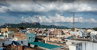
Kavindapadi, also known as Kavundapadi, is located in Erode District of Tamil Nadu, India which is one of the major producers of sugar in India. It is also famous for its agriculture, producing the lump sum amount of sugarcane and bananas to the people of Tamil Nadu. Kavindapadi is located on the way of Erode to Sathyamangalam.
Sivagiri is a panchayat town in Erode district in the Indian state of Tamil Nadu.

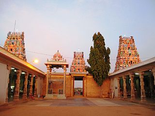
Avinashi is a municipality in the Tiruppur district in the Indian state of Tamil Nadu. Avinashi is one among the nine taluks of the district. It is one of the most popular pilgrim destinations in the Western Tamil Nadu region. It is located off of National Highway NH544, which bypasses the town. The history of the town is centered around the Avinasilingeswarar temple. The town was previously a part of the Coimbatore district until Tirupur was carved out as a separate district from the erstwhile districts of Coimbatore and Erode. It is a stopping place for vehicles travelling from the western part of Tamil Nadu to Chennai and Cochin. Avinashi Taluk has one Town Panchayat and Block Panchayat by administration. Avinashi Town Panchayat has 18 wards with around 28868 people population. Avinashi Block Panchayat has 19 wards along with 31 Village Panchayats.
Sanakarlingapuram is an industrial panchayat village in Virudhunagar district in the Indian state of Tamil Nadu.
Pernambut is a town and village headquarters also a Municipality in Vellore district in the Indian state of Tamil Nadu. The economy is dependent on leather tanning industry, earning it the nickname Leather Tanning city of Tamil Nadu. Pernambut is a municipality and headquarters of Pernambut Taluk which is an administrative division comprising 52 Revenue villages in the district of Vellore.
