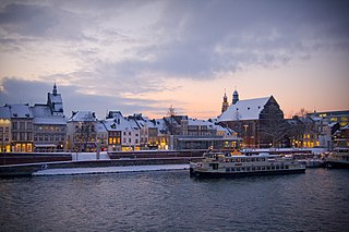
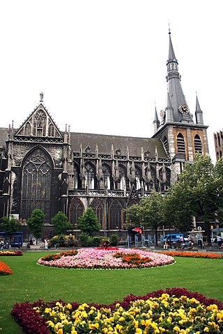
Maastricht is a city and a municipality in the southeastern Netherlands. It is the capital and largest city of the province of Limburg. Maastricht is located on both sides of the Meuse, at the point where the river is joined by the Jeker. Mount Saint Peter (Sint-Pietersberg) is largely situated within the city's municipal borders. Maastricht is adjacent to the border with Belgium and is part of the Meuse-Rhine Euroregion, an international metropolis with a population of about 3.9 million, which includes the nearby German and Belgian cities of Aachen, Liège, and Hasselt.

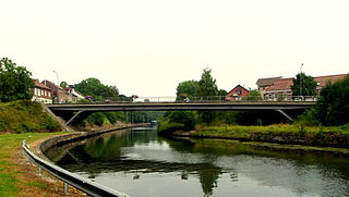
The Meuse or Maas is a major European river, rising in France and flowing through Belgium and the Netherlands before draining into the North Sea from the Rhine–Meuse–Scheldt delta. It has a total length of 925 km.

Limburg, also known as Belgian Limburg, is a province in Belgium. It is the easternmost of the five Dutch-speaking provinces that together form the Region of Flanders, which is one of the three main political and cultural sub-divisions of modern-day Belgium. As of January 2024, Limburg had a population of 0.9 million.

Maaseik is a city and municipality in the Belgian province of Limburg. Both in size and in population, it is the 8th largest municipality in Limburg. The town is the seat of the administrative arrondissement of Maaseik (kieskanton). Internationally, Maaseik is known as the assumed birthplace of the famous Flemish painters Jan and Hubert van Eyck.
Lanaken is a municipality located in the Belgian province of Limburg. On January 1, 2007, the municipality of Lanaken had a total population of 24,724. Its area is 59.00 km2 which gives a population density of 415 inhabitants per km2.

Bassenge is a municipality of Wallonia located in the province of liège, Belgium.

Visé is a city and municipality of Wallonia, located on the river Meuse in the province of Liège, Belgium.
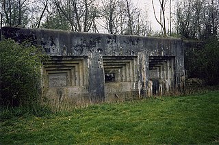
Fort Eben-Emael is an inactive Belgian fortress located between Liège and Maastricht, on the Belgian-Dutch border, near the Albert Canal, outside the village of Ében-Émael. It was designed to defend Belgium from a German attack across the narrow belt of Dutch territory in the region. Constructed in 1931–1935, it was reputed to be impregnable and at the time, the largest in the world.

The Jeker is a river in Belgium and in the Netherlands. It is a left-bank tributary to the river Meuse. The source of the Jeker is near the village of Geer, in the Belgian province of Liège. The river is approximately 54 kilometres (34 mi) long, of which about 50 kilometres (31 mi) is in Belgium and 4 kilometres (2.5 mi) in the Netherlands, where it flows into the river Meuse at Maastricht (Netherlands).
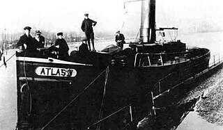
Atlas V was a Belgian tugboat which was armed by resistance forces, sailing under the command of Jules Hentjens during the First World War. On the night of 3 and 4 January 1917, the boat arrived in The Netherlands with 107 people aboard from Liège, Belgium, which was occupied by the German Empire.
Oost-Maarland is a village in the south east of the European country Netherlands. There it is an administrative population centre in the Eijsden-Margraten municipality, which forms part of the province of Limburg. In fact Oost-Maarland consists of two separate places with a different history. One is the village and former municipality of Oost, whereas the other is an in a distance of a few hundred metres separately to the southeast situated township called Maarland.

The Battle of Fort Ében-Émael was a battle between Belgian and German forces that took place between 10 May and 11 May 1940, and was part of the Battle of Belgium and Fall Gelb, the German invasion of the Low Countries and France. An assault force of German paratroopers, Fallschirmjäger, was tasked with assaulting and capturing Fort Ében-Émael, a Belgian fortress whose strategic position and strong artillery emplacements dominated several important bridges over the Albert Canal. These carried roads which led into the Belgian heartland and were what the German forces intended to use to advance. As some of the German airborne forces assaulted the fortress and disabled the garrison and the artillery pieces inside it, others simultaneously captured three bridges over the canal. Having disabled the fortress, the airborne troops were then ordered to protect the bridges against Belgian counter-attacks until they linked up with ground forces from the German 18th Army.
The Diocese of Liège is a Latin Church ecclesiastical territory or diocese of the Catholic Church in Belgium. The diocese was erected in the 4th century and presently covers the same territory as Belgium's Liège Province, but it was historically much larger. Currently, the diocese is a suffragan in the ecclesiastical province of the Archdiocese of Mechelen-Brussels. Its cathedra is found within St. Paul's Cathedral in the episcopal see of Liège.

The fortified position of Liège was established after the First World War by Belgium to block the traditional invasion corridor through Belgium between Germany and France. In the First World War the Belgian Army held up the Germans for a week at Liège, delaying the German invasion of France, caused Belgium to consider a similar defensive strategy. Belgium rebuilt the Liège fortifications and extended them onto the Pays de Herve closer to Germany, using the most advanced fortification technology available.
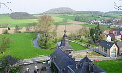
Mount Saint Peter, also referred to as Caestert Plateau, is the northern part of a plateau running north to south between the valleys of the river Geer to the west, and the Meuse to the east. The plateau runs from Maastricht in the Netherlands, through Riemst in Belgian Limburg almost to the city of Liège in Belgium, thus defining the topography of this border area between Flanders, Wallonia and the Netherlands. The name of the hill, as well as the nearby village and church of Sint Pieter and the fortress of Sint Pieter, refers to Saint Peter, one of the Twelve Apostles.

Boschpoort is a neighbourhood of Maastricht in the Dutch province of Limburg. The suburb is situated in the North Western area of the town, on the West bank of the river Meuse. The Dörp as it is colloquially known is home to approximately 1500 people.

Château Neercanne is a restaurant located in Maastricht in the Netherlands. It is a fine dining restaurant that was awarded one or two Michelin stars in the periods 1957-1982 and 1986–2018.
The 7th Infantry Division(7de infanterie divisie) was an infantry division of the Belgian Army that existed during the Battle of Belgium during the Second World War.

Hasselt-Maastricht railway is a railway track that goes from the Y-intersection Beverst with the Hasselt-Liège railway from Hasselt to Maastricht. The line is 17.2 km (10.7 mi) long.
Ében-Émael is a village of Wallonia and a district of the municipality of Bassenge, located in the province of Liège, Belgium.