
Myawaddy Township is a township of Myawaddy District in the Kayin State of Burma (Myanmar). It is the only township in Myawaddy District. The administrative seat is the town of Myawaddy.

Kawkareik Township is a township of Kawkareik District in the Karen State of Myanmar. The principal town is Kawkareik. Kawkareik township is the second most populated township in Karen State and there are many small villages inside.

Payathonzu is a town in the Karen State of south Myanmar, close to the border with Thailand. It is separated from the Thai border township of Nong Lu by the Three Pagodas Pass. It is also the administrative seat of Hpayarthonezu Sub-township in Kyain Seikgyi Township, Kawkareik District of Kayin State in Myanmar.

Kawkareik, also spelled as Kawkarike, is a town in Karen State, Myanmar. It is the capital of Kawkaraik District and Kawkaraik Township.

Kalewa Township is a township of Kale District in Sagaing Division of western Burma (Myanmar). The principal town and administrative seat is Kalewa. The Paluzawa coalmines are located in Kalewa township.
Kanni is a village in Banmauk Township, Katha District, in the Sagaing Region of northern-central Burma.
Kanni is a village in Kyain Seikgyi Township, Kawkareik District, in the Kayin State of Myanmar. It is located on the Zami River.
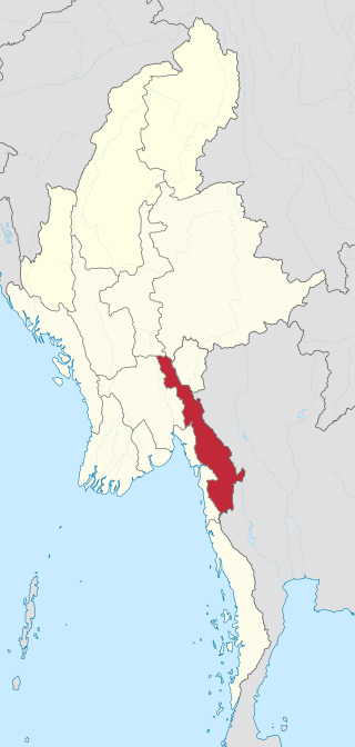
Kayin State, formerly known as Karen State, is a state of Myanmar. The capital city is Hpa-An, also spelled Pa-An.
Peinnegon is a village in northeastern Kyain Seikgyi Township, Kawkareik District, in the Kayin State of Myanmar.
Kaingdaw is a village in Kyain Seikgyi Township, Kawkareik District, in the Kayin State of Myanmar. It is located on the left (western) bank of the Haungthayaw River.
Paya-ngokto is a village in Kyain Seikgyi Township, Kawkareik District, in the Kayin State of Myanmar. It is located on the west bank of Zami River.
Katokkra is a village in Kyain Seikgyi Township, Kawkareik District, in the Kayin State of Myanmar. Katokkra is on the Haungtharaw River and lies only 3.22 kilometres (2.00 mi) from the border with Thailand.
Akalaw is a village in Kyain Seikgyi Township, Kawkareik District, in the Kayin State of Myanmar. It is near the convergence of the Winyaw and Zami Rivers.
Ywathit is a village in Kyain Seikgyi Township, Kawkareik District, in the Kayin State of Myanmar. It is located on the eastern bank of the Winyaw River.

Kyondoe is a town located within the Kawkareik District of Kayin State, Myanmar. It is located on the India–Myanmar–Thailand Trilateral Highway and eastern bank of Haungtharaw River.

Myoe Haung or Myohaung is a village in Kyain Seikgyi Township, Kawkareik District, in the Kayin State of Burma (Myanmar). It is on the Sadaw Marsh, eastern part of the foothills of the Tenasserim Range.

Kale is a large village in Kyain Seikgyi Township, Kawkareik District, in the Kayin State of Myanmar. According to 2014 Myanmar Census, the total population in Kale is 5,355. The Kha Lel village tract contains 5 villages and in 2014, it had a total population of 8,869 people.
Lutshan is a village in Kyain Seikgyi Township, Kawkareik District, in the Kayin State of Myanmar.

Taungdi Pwo Eastern Karen: တံင့်တီႋ; Burmese: တောင်ဒီး ) is a large village in Kyain Seikgyi Township, Kawkareik District, in the Kayin State of Myanmar.
Sinpyay, formerly called Shitpyit is a village in southwestern Kyain Seikgyi Township, Kawkareik District, in the Karen State of Myanmar. It is a location on the Death Railway. The village is located in Kyauk Bi Lu village tract.
This page is based on this
Wikipedia article Text is available under the
CC BY-SA 4.0 license; additional terms may apply.
Images, videos and audio are available under their respective licenses.

