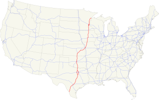
Interstate 35 (I-35) is a major Interstate Highway in the central United States. As with most interstates that end in a five, it is a major cross-country, north-south route. It stretches from Laredo, Texas, near the Mexican border to Duluth, Minnesota, at Minnesota State Highway 61 and 26th Avenue East. The highway splits into I-35E and I-35W in two separate places, the Dallas–Fort Worth metroplex in Texas and at the Minnesota twin cities of Minneapolis–Saint Paul.
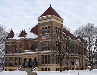
Watonwan County is a county in the U.S. state of Minnesota. As of the 2010 United States Census, the population was 11,211. Its county seat is St. James.

The Midwestern United States, also referred to as the American Midwest, Middle West, or simply the Midwest, is one of four census regions of the United States Census Bureau. It occupies the northern central part of the United States. It was officially named the North Central Region by the Census Bureau until 1984. It is located between the Northeastern United States and the Western United States, with Canada to its north and the Southern United States to its south.
In the United States, an unorganized territory is a region of land under U.S. Sovereignty that is not within the bounds of a U.S. state and that is without a government established by the United States Congress through an organic act. The term was historically applied either to a newly acquired region not yet constituted as an organized incorporated territory, or to a region previously part of an organized incorporated territory left "unorganized" after part of it had been organized and achieved the requirements for statehood. The U.S. currently exercises sovereignty over ten unorganized territories: American Samoa, Baker Island, Howland Island, Jarvis Island, Johnston Atoll, Kingman Reef, Midway Atoll, Navassa Island, Palmyra Atoll and Wake Island.
A civil township is a widely used unit of local government in the United States that is subordinate to a county. The term town is used in New England, New York, and Wisconsin to refer to the equivalent of the civil township in these states. Specific responsibilities and the degree of autonomy vary based on each state. Civil townships are distinct from survey townships, but in states that have both, the boundaries often coincide and may completely geographically subdivide a county. The U.S. Census Bureau classifies civil townships as minor civil divisions. Currently, there are 20 states with civil townships.
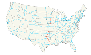
U.S. Route 69 (US 69) is a major north–south United States highway. When it was first created, it was only 150 miles (241 km) long, but it has since been expanded into a Minnesota to Texas cross-country route. The highway's southern terminus is in Port Arthur, Texas at an intersection with State Highway 87. Its northern terminus is in Albert Lea, Minnesota at Minnesota State Highway 13.

Eagle Mountain is the highest natural point in Minnesota, United States, at 2,301 feet (701 m). It is in northern Cook County, in the Boundary Waters Canoe Area Wilderness and Superior National Forest in the Misquah Hills, northwest of Grand Marais. It is a Minnesota State Historic Site.

The Central United States is sometimes conceived as between the Eastern and Western as part of a three-region model, roughly coincident with the U.S. Census' definition of the Midwestern United States plus the western and central portions of the U.S. Census' definition of the Southern United States. The Central States are typically considered to consist of North Dakota, South Dakota, Nebraska, Kansas, Oklahoma, Texas, Minnesota, Iowa, Missouri, Arkansas, Louisiana, Wisconsin, Illinois, Michigan, Indiana, Ohio, Kentucky, Tennessee, West Virginia, Mississippi and Alabama are also considered to be central states. Chicago is the area's largest city and metropolitan area, other large cities with large metropolitan areas would be Houston, Dallas, Fort Worth, San Antonio, Austin, Oklahoma City, Tulsa, Kansas City, Kansas and Kansas City, Missouri, Topeka, Wichita, Omaha, Nebraska and Lincoln, Minneapolis and St. Paul, Madison and Milwaukee, St. Louis, Louisville, Lexington, Detroit, Cincinnati, Cleveland, Columbus, Toledo, Dayton, Rockford, Peoria, Indianapolis, Evansville, Fort Wayne and South Bend.
Bachelor Lake is a lake in Brown County, Minnesota in the northeastern part of Stark township. Covering 79.80 acres, it is an officially protected water of the State of Minnesota. The lake is within the Cottonwood River Major Watershed. The lake’s elevation is 1,004 feet (306 m), and it is zoned as a shoreland area which is regulated as a shoreland management water.

Saginaw is an unincorporated area in Saint Louis County, Minnesota, United States. Although unincorporated, Saginaw has a post office with the ZIP code 55779.
Fairbanks is an unincorporated community in Fairbanks Township, Saint Louis County, Minnesota, United States; located within the Superior National Forest.
Central Lakes is an unincorporated community in Saint Louis County, Minnesota, United States.
Ash Lake is an unincorporated community in Saint Louis County, Minnesota, United States; located within the Kabetogama State Forest.

The following outline is provided as an overview of and topical guide to the U.S. state of Minnesota:
The Jeanette State Forest is a state forest located in St. Louis County, Minnesota. The forest is within the limits of the Superior National Forest's Boundary Waters Canoe Area Wilderness, and thus falls under the federal jurisdiction and management of the United States Forest Service.
Island Lake is an unincorporated community in Beltrami County, in the U.S. state of Minnesota.
Alida is an unincorporated community in Clearwater County, in the U.S. state of Minnesota.
Wall Lake is an unincorporated community in Otter Tail County, in the U.S. state of Minnesota.
