
Jindo County (Jindo-gun) is a county in South Jeolla Province, South Korea. It consists of the island of Jindo and several smaller nearby islands. Jindo Bridge connects Jindo county with Haenam county.
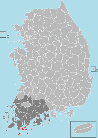
Wando County is a county in South Jeolla Province, South Korea. It takes its name from the island of Wando, which is the largest island within the county and serves as the county seat.
126 is the natural number following 125 and preceding 127.

The Molucca Sea is located in the western Pacific Ocean, around the vicinity of Indonesia, specifically bordered by the Indonesian Islands of Celebes (Sulawesi) to the west, Halmahera to the east, and the Sula Islands to the south. The Molucca Sea has a total surface area of 77,000 square miles. The Molucca Sea is rich in coral and has many diving sites due to the deepness of its waters. The deepness of the water explains the reasoning behind dividing the sea into three zones, which functions to transport water from the Pacific Ocean to the shallower seas surrounding it. The deepest hollow in the Molucca Sea is the 15,780-foot (4,810-meter) Batjan basin. This region is known for its periodic experiences of earthquakes, which stems from the sea itself being a micro plate, in which the Molucca Sea is being subducted in two opposite directions: one in the direction of the Eurasian Plate to the west and the other in the direction of the Philippine Sea Plate to the east.

Bligh Island Marine Provincial Park is a provincial park in British Columbia, Canada.
Cormorant Channel Marine Provincial Park is a provincial park in British Columbia, Canada, located in the Pearse Islands, a small archipelago to the east of Cormorant Island and the Village of Alert Bay at the western end of Johnstone Strait.
Claud Elliott Provincial Park is a provincial park in British Columbia, Canada located on northern Vancouver Island approximately 50 kilometres (31 mi) southeast of Port McNeill, between the Tsitsika River and Bonanza Lake, near the community of Woss.
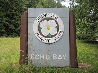
Echo Bay Marine Provincial Park is a provincial park in British Columbia, Canada, established in 1971 and containing 1.5 hectares. It is located at the bay of the same name, offshore from the community of the same name, which is the location of the Simoom Sound post office and is on the west side of Gilford Island.

Nuchatlitz Provincial Park is a provincial park in British Columbia, Canada, located on the northwest side of Nootka Island, facing Nuchatlitz Inlet, on the west coast of Vancouver Island. Established in 1996, the park contains approximately 2105 ha.

The Gwa'sala-Nakwaxda'xw Nations are an amalgamation of two Kwakwaka'wakw peoples in a band government based on northern Vancouver Island in British Columbia, whose main reserve community is near the town of Port Hardy in the Queen Charlotte Strait region of the Central Coast region of British Columbia, Canada. In the 1960s the Gwa'sala (Gwaʼsa̱la), the 'Nakwaxda'xw (ʼNakʼwaxdaʼx̱w) and the Kwakiutl peoples were amalgamated. Eventually the Gwa'sala-'Nakwaxda'xw Nations and the Kwakiutl First Nation separated into the two groups that are recognized by the federal government to this day. Gwa'sala-'Nakwaxda'xw Nations were forcibly relocated from their homelands to a location near Port Hardy.
Ḵwiḵwa̱sut'inux̱w Ha̱xwa'mis, formerly the Kwicksutaineuk-ah-kwa-mish First Nation is a First Nations band government based on northern Vancouver Island in British Columbia, Canada, in the Queen Charlotte Strait region. It is a member of the Musgamagw Tsawataineuk Tribal Council, along with the ‘Namgis First Nation and the Tsawataineuk First Nation. The Kwikwasut'inuxw and Haxwa'mis are two of the many subgroups of the peoples known as Kwakwaka'wakw, which has two meanings: "smoke of the world" or "beach at the north side of the river."
This is a list of points in the Philippines that are farther north, south, east, or west than any other location in the country. Also included are extreme points in elevation, extreme distances, and other points of geographic interest.
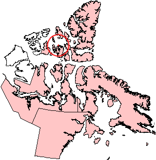
Helena Island is one of the uninhabited members of the Queen Elizabeth Islands of the Canadian Arctic islands in the Qikiqtaaluk Region of Nunavut, Canada. It is along the northern coast of Bathurst Island, separated by Sir William Parker Strait. Seymour Island is located off its west coast. Located at 76°39'N 101°04'W, Helena Island is 327 km2 (126 sq mi) in area and measures 41 by 12.8 km.

Samgakji Station is a subway station on the Line 4 and Line 6 of the Seoul Metropolitan Subway. The Seoul War Memorial is a short walk away from exits 11 and 12. This station is on the west end of the Yongsan Garrison, which is a short walk from exit 13. Although not connected to this station by a transfer passageway, Namyeong station on Line 1 is a short walk from here.
Sutlej Channel is a channel or strait on the north sides of Broughton Island and North Broughton Island, or the Broughton Archipelago of the Queen Charlotte Strait region of the Central Coast of British Columbia, Canada. The channel separates those islands from the adjacent mainland and includes Greenway Sound. It was named for HMS Sutlej.
The Tlowitsis Nation, formerly the Klowitsis Tribe, the Turnour Island Band and the Tlowitsis-Mumtagila First Nation, is the Indian Act band government of the Ławit'sis (Tlowitsis) tribe of the Kwakwaka'wakw peoples, located in the Queen Charlotte Strait-Johnstone Strait area in the Discovery Islands between Vancouver Island and the British Columbia mainland in Canada. Ławit'sis territory covers parts of northern Vancouver Island, Johnstone Strait, and adjoining inlets of the mainland. Kalugwis, on Turnour Island, was their principal community in times past, but the band's offices are in the city of Campbell River to the southeast. Hanatsa IR No. 6 on Port Neville is the most populated of the band's Indian reserves.
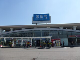
Mokpo station is a station on the Honam Line in Mokpo, South Jeolla Province. It is the westernmost railway station in South Korea. This station is the last stop on the Honam Line. Being located in the southwestern part of the Korean peninsula, it is used by customers who visit Jeju Island, Heuksan Island, and Hong Island in connection with KTX.
Wells Passage is a strait and marine waterway in the northeastern Queen Charlotte Strait region of the Central Coast of British Columbia, Canada, on the west side of North Broughton Island. Across from that island, the headland at the northwest entrance to the passage is Compton Point.
Drury inlet is an inlet in the Queen Charlotte Strait region of the Central Coast of British Columbia, Canada, extending west from Wells Passage to the northwest of North Broughton Island, northwest of the town of Port Hardy. Branching off to the northeast from the north side of the head of the inlet is Actaeon Sound.
The Claud Elliott Creek Ecological Reserve is located southwest of the junction of Claud Elliott Creek and the Tsitsika River on northern Vancouver Island, southwest of the community of Sayward. The reserve, which was created to protect representative old-growth montane forests, was established in 1989, comprising approximately 231 hectares. It was expanded slightly in 2004 to a current total area of approximately 233 hectares.