The Khattak tribe are a prominent Pashtun tribe located in the Khattak territory, which consists of Karak, Nowshera, Kohat districts of Khyber Pakhtunkhwa, Pakistan.
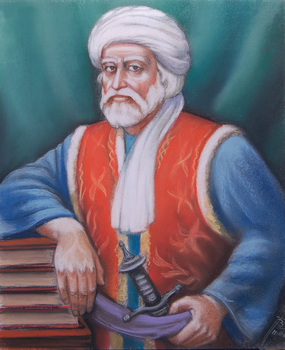
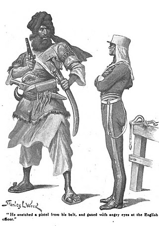
Khošāl Khān Khaṭak (Pashto: خوشال خان خټک; Urdu, Persian: خوشحال خان خٹک; 1613 – 20 February 1689), also known as Khushal Baba, was a 17th-century Pashtun poet, chief, and warrior. Khushal Khan served the Mughal Empire protecting them from Pashtun warriors over most of his lifespan. After being expelled from his tribal chiefdom and replaced with his son by his Mughal superiors, Khushal Khan turned against the Mughals. Afterwards, Khushal preached the union of all Pashtuns, and encouraged revolt against the Mughal Empire, promoting Pashtun nationalism in the last years of his life through poetry. Much of Khushal's poetry is in Pashto but some is also in Persian. Khushal is considered the "father of Pashto literature" and the national poet of Afghanistan.

Nowshera District is a district in the Peshawar Division of the Khyber Pakhtunkhwa province of Pakistan. The capital and district headquarter is Nowshera city.

Karak District is a district in Kohat Division of Khyber Pakhtunkhwa province in Pakistan. It is situated to the south of Kohat District and on the north side of Bannu and Lakki Marwat districts on the main Indus Highway between Peshawar and Karachi – it is 131 km from the provincial capital Peshawar. It gained a district status in 1982, prior to which it was part of Kohat District.

Nowshera is the capital city of Nowshera District in the Khyber Pakhtunkhwa province of Pakistan. It is the 78th largest city in Pakistan and ninth largest city in the province of Khyber Pakhtunkhwa.

Hangu District is a district within the Kohat Division of the Khyber Pakhtunkhwa. The district takes its name from the town of Hangu, which is its administrative centre. The name Hangu may also sometimes be applied to the Miranzai Valley which is partly within the district, bordering the Samana Range.
Kohat Division is one of the seven divisions in the Khyber Pakhtunkhwa province of Pakistan. It consists of five districts: Hangu, Karak, Kohat, Kurram, and Orakzai. The division borders Bannu Division to the south and west, Peshawar Division to the north and east, the province of Punjab to the east, and Afghanistan to the northwest. CNIC code of Kohat Division is 14.
Karak is the headquarters of Karak District in the Khyber Pakhtunkhwa province of Pakistan. It is 123 km from Peshawar on the main Indus Highway between Peshawar and Karachi. It is located at 33°7'12N 71°5'41E. Karak is said to be the single district in Pakistan that is inhabited by only one tribe of Pashtuns — the Khattaks.
Akora Khattak or Sarai Akora is a town in the Jehangira tehsil of the Nowshera District in the Khyber Pakhtunkhwa province of Pakistan. Its location is adjacent to the Kabul River, which converges with the Indus River about 15 kilometres downstream. Neighbouring places are Nowshera Cantonment to the west and Jahangira town to the east.
Teri is Former Tehsil of Kohat now a village and Union Council in Karak District of Khyber Pakhtunkhwa, Pakistan. It is located at 33°18'0"N 71°6'0"E with an altitude of 634 metres (2,083 feet).
Jehangira is a town in the Khyber-Pakhtunkhwa province of Pakistan.
Manki (Urdu: مانکی is a town and Union Council of Nowshera District in Khyber Pakhtunkhwa, Pakistan. It is located to the south of Swabi.
Bara Bandai is a village in Swat, Khyber Pakhtunkhwa, Pakistan, known as an area crossed by Alexander The Great during his invasion of the subcontinent. The people of village Bara Bandai belong to subsection Naikpikhel of Yusufzai the biggest and largest tribe of Pashtun or Pakhtun tribes. It is one of the Provincially Administered Tribal Areas (PATA) of Pakistan. The village contains a small series of mountains and a forest, residential area starting from meadows of mountainsand merge with river swat on right bank, a village market, vast land for crops, number of canals, and a part of the Swat river. Mountains of the village include Usmani Sar, Kafar Ghat and Najia Top.
Khattak is a Pashtun/Pakhtun surname found among the pashtuns of northern Pakistan and Afghanistan.

The Pervez Khattak administration was the coalition of provincial government of Khyber Pakhtunkhwa between Pakistan Tehreek-e-Insaf (PTI), the Islamist Jamaat-e-Islami (JI), Qaumi Watan Party (QWP), and Awami Jamhuri Ittehad Pakistan (AJIP). AJIP later merged itself with PTI.
Lachi is one of the two tehsils in the Kohat District of Khyber Pakhtunkhwa province in Pakistan, located south of the district capital Kohat. It houses about 100,000 inhabitants, living in 1,161 square kilometres (448 sq mi). The tehsil is subdivided into nine union councils. About 40% of the working population is employed outside the tehsil.It is a rural area where most households' livelihood depends on remittances and subsistence farming. Education is provided through several private and government high schools, as well as a government degree college affiliated with Kohat University.
The Khan of Hangu, also known as Raees e Hangu, was the title of the tribal chiefs of Hangu valley. The first to take the title was(Ali mardankhan also known as mardu khan in the 16th century. After him, his clan, the Mardukhel, ruled the valley for more than 400 years from 1500 to 1915. They belong to the Miranzai sub-tribe of the larger Bangash tribe.
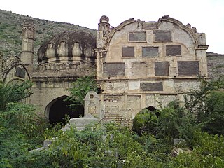
Adamzai is a village in Nowshera District, Khyber Pakhtunkhwa province, Pakistan, located between Akora Khattak and Shaidu. Khan's living here belong to the khushal khan khattak lineage of the khattak tribe. The tomb of Great Afghan Warrior and pashto poet Khushal Khan Khattak is situated in the outskirts of adamzai.
Jehangira Tehsil is a tehsil located in Nowshera District, Khyber-Pakhtunkhwa, Pakistan. The tehsil is named after the Jehangira town, which is located on the GT Road. A village, Hasan Darra, also exists in Tehsil Jehangira.
Malik Akorai, also known as Ako, was the first Chief of the Khattak tribe in the 16th century. Originally from Karbogha, he later moved to Khwarra due to a quarrel with his Karbogha relatives. Ako, with his tribe, engaged in conflicts with the neighboring Bangashes of Darsamand. Notably, Ako resisted Mughal Empire's forces and secured favorable terms, including a transit duty on cattle along the Peshawar-Attock road. He established Akora, which became the tribe's capital.

