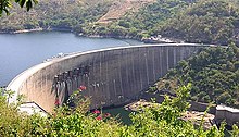
The Kariba Dam is a double curvature concrete arch dam in the Kariba Gorge of the Zambezi river basin between Zambia and Zimbabwe. The dam stands 128 metres (420 ft) tall and 579 metres (1,900 ft) long. The dam forms Lake Kariba, which extends for 280 kilometres (170 mi) and holds 185 cubic kilometres (150,000,000 acre⋅ft) of water.

Zambia, officially the Republic of Zambia, is a landlocked country at the crossroads of Central, Southern and East Africa. It is typically referred to being in South-Central Africa or Southern Africa. It is bordered to the north by the Democratic Republic of the Congo, Tanzania to the north-east, Malawi to the east, Mozambique to the southeast, Zimbabwe and Botswana to the south, Namibia to the southwest, and Angola to the west. The capital city of Zambia is Lusaka, located in the south-central part of Zambia. The population is concentrated mainly around Lusaka in the south and the Copperbelt Province to the north, the core economic hubs of the country.

The Zambezi is the fourth-longest river in Africa, the longest east-flowing river in Africa and the largest flowing into the Indian Ocean from Africa. Its drainage basin covers 1,390,000 km2 (540,000 sq mi), slightly less than half of the Nile's. The 2,574 km (1,599 mi) river rises in Zambia and flows through eastern Angola, along the north-eastern border of Namibia and the northern border of Botswana, then along the border between Zambia and Zimbabwe to Mozambique, where it crosses the country to empty into the Indian Ocean.

Victoria Falls is a waterfall on the Zambezi River in southern Africa, which provides habitat for several unique species of plants and animals. It is located on the border between Zambia and Zimbabwe and is one of the world's largest waterfalls, with a width of 1,708 m (5,604 ft).
Kariba is a resort town in Mashonaland West province, Zimbabwe, located close to the Kariba Dam at the north-eastern end of Lake Kariba, near the Zambian border. According to the 2022 Population Census, the town had a population of 27,600.

Lake Kariba is the world's largest artificial lake and reservoir by volume. It lies 1,300 kilometres (810 mi) upstream from the mouth of the Zambezi river on Indian Ocean, along the border between Zambia and Zimbabwe. Lake Kariba was filled between 1958 and 1963 following the completion of the Kariba Dam at its northeastern end, flooding the Kariba Gorge on the Zambezi River.

Livingstone is a city in Zambia. Until 1935, it served as the capital of Northern Rhodesia. Lying 10 km (6 mi) to the north of the Zambezi River, it is a tourism attraction center for the Victoria Falls and a border town with road and rail connections to Zimbabwe on the other side of the Victoria Falls. A historic British colonial city, its present population was enumerated at 177,393 inhabitants at the 2022 census. It is named after David Livingstone, the Scottish explorer and missionary who was the first European to explore the area. Until 2011, Livingstone was the provincial capital of Zambia's Southern Province.

Mana Pools National Park is a 219,600-hectare (543,000-acre) wildlife conservation area and national park in northern Zimbabwe. It is a region of the lower Zambezi in Zimbabwe where the floodplain turns into a broad expanse of lakes after each rainy season. As the lakes gradually dry up and recede, the region attracts many large animals in search of water, making it one of Africa's most renowned game-viewing regions.

Southern Province is one of Zambia's ten provinces, and home to Zambia's premier tourist attraction, Mosi-oa-Tunya, shared with Zimbabwe. The centre of the province, the Southern Plateau, has the largest area of commercial farmland of any Zambian province, and produces most of the maize crop.

Binga District is a district of Zimbabwe in southern Africa. It is located in Matabeleland North just south of Kariba Lake, across the lake from Zambia It lies along the southern Zambezi Escarpment.

The Nyami Nyami, otherwise known as the Zambezi River God or Zambezi Snake Spirit, is one of the most important gods of the Tonga people living along the Zambezi River. The Nyami Nyami is believed to protect the Tonga people and give them sustenance in difficult times. The River God is usually portrayed as male.

The Chirundu Bridge now consists of two road bridges side by side across the Zambezi River between the small town of Chirundu, Zambia and the village of Chirundu, Zimbabwe. At this location around 65 km downstream from the Kariba Dam the river is about 400 m wide. The bridges were once seen as part of a Cape to Cairo Road and thus are on the Harare to Lusaka section of the route.
The Tonga people of Zambia and Zimbabwe are a Bantu ethnic group of southern Zambia and neighbouring northern Zimbabwe, and to a lesser extent, in Mozambique. They are related to the Batoka who are part of the Tokaleya people in the same area, but not to the Tonga people of Malawi. In southern Zambia they are patrons of the Kafue Twa. They differ culturally and linguistically from the Tsonga people of South Africa and southern Mozambique.

The wildlife of Zimbabwe occurs foremost in remote or rugged terrain, in national parks and private wildlife ranches, in miombo woodlands and thorny acacia or kopje. The prominent wild fauna includes African buffalo, African bush elephant, black rhinoceros, southern giraffe, African leopard, lion, plains zebra, and several antelope species.
Zimbabwe Electricity Supply Authority, (ZESA) whose official name is ZESA Holdings (Private) Limited, is a state-owned company whose task is to generate, transmit, and distribute electricity in Zimbabwe.
The following outline is provided as an overview of and topical guide to Zambia:
Operation Noah was a wildlife rescue operation on the Zambezi River lasting from 1958 to 1964. In the late 1950s, Northern and Southern Rhodesia constructed the Kariba Dam hydroelectric power station across the Zambezi River, at the Kariba Gorge, about 400 km from Victoria Falls. The Kariba Dam mostly provided electric power to both countries, created Lake Kariba, the world's largest man-made lake, and flooded the Kariba Gorge - home to thousands of native animals and the local Tonga people. In a wildlife rescue operation lasting 5 years, over 6000 animals were rescued and relocated to the mainland.
Zambia, officially known as the Republic of Zambia, is a landlocked country in Southern Africa. The neighbouring countries are the Democratic Republic of the Congo to the north, Tanzania to the north-east, Malawi to the east, Mozambique, Zimbabwe, Botswana, and Namibia to the south, and Angola to the west. The capital city is Lusaka, located in the southeast of the country. The population is concentrated mainly around the capital and the Copperbelt to the northwest.
The proposed Batoka Gorge Hydroelectric Power Station is a 2400 MW hydroelectric power station, planned for the Zambezi River on the international border between Zambia and Zimbabwe.
The M15 Makuti-Kariba Highway is a 2-way asphalt surface international highway from the A1 Highway at Makuti to Zambia via the Kariba Dam Wall. The maximum speed on this road is 120 kilometres (75 mi) per hour.