
South Africa occupies the southern tip of Africa, its coastline stretching more than 2,850 kilometres from the desert border with Namibia on the Atlantic (western) coast southwards around the tip of Africa and then northeast to the border with Mozambique on the Indian (eastern) coast. The low-lying coastal zone is narrow for much of that distance, soon giving way to a mountainous escarpment that separates the coast from the high inland plateau. In some places, notably the province of KwaZulu-Natal in the east, a greater distance separates the coast from the escarpment. Although much of the country is classified as semi-arid, it has considerable variation in climate as well as topography. The total land area is 1,220,813 km2 (471,359 sq mi). It has the 23rd largest Exclusive Economic Zone of 1,535,538 km2 (592,875 sq mi).

The Western Cape is a province of South Africa, situated on the south-western coast of the country. It is the fourth largest of the nine provinces with an area of 129,449 square kilometres (49,981 sq mi), and the third most populous, with an estimated 7 million inhabitants in 2020. About two-thirds of these inhabitants live in the metropolitan area of Cape Town, which is also the provincial capital. The Western Cape was created in 1994 from part of the former Cape Province. The two largest cities are Cape Town and George.

The Northern Cape is the largest and most sparsely populated province of South Africa. It was created in 1994 when the Cape Province was split up. Its capital is Kimberley. It includes the Kalahari Gemsbok National Park, part of the Kgalagadi Transfrontier Park and an international park shared with Botswana. It also includes the Augrabies Falls and the diamond mining regions in Kimberley and Alexander Bay.

The Karoo is a semi-desert natural region of South Africa. No exact definition of what constitutes the Karoo is available, so its extent is also not precisely defined. The Karoo is partly defined by its topography, geology and climate, and above all, its low rainfall, arid air, cloudless skies, and extremes of heat and cold. The Karoo also hosted a well-preserved ecosystem hundreds of million years ago which is now represented by many fossils.

George Municipality is a local municipality within the Garden Route District Municipality, in the Western Cape province of South Africa. As of 2011, the population is 193,672. Its municipality code is WC044.
Beaufort West Municipality is a local municipality located in the Western Cape province of South Africa. As of 2011, the population is 49,586. Its municipality code is WC053.

The Central Karoo District Municipality is a district municipality located in the Western Cape province of South Africa. Its municipality code is DC5.

Laingsburg Municipality is a local municipality located in the Western Cape province of South Africa. As of 2022, the population is 11,366. Its municipality code is WC051.

The Karoo Supergroup is the most widespread stratigraphic unit in Africa south of the Kalahari Desert. The supergroup consists of a sequence of units, mostly of nonmarine origin, deposited between the Late Carboniferous and Early Jurassic, a period of about 120 million years.
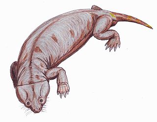
The Cistecephalus Assemblage Zone is a tetrapod assemblage zone or biozone found in the Adelaide Subgroup of the Beaufort Group, a majorly fossiliferous and geologically important geological group of the Karoo Supergroup in South Africa. This biozone has outcrops located in the Teekloof Formation north-west of Beaufort West in the Western Cape, in the upper Middleton and lower Balfour Formations respectively from Colesberg of the Northern Cape to east of Graaff-Reinet in the Eastern Cape. The Cistecephalus Assemblage Zone is one of eight biozones found in the Beaufort Group, and is considered to be Late Permian in age.

Vachellia karroo, commonly known as the sweet thorn, common acacia, Karoo thorn, Cape gum or cockspur thorn, is a species of Vachellia, in the Mimosa sub-family (Mimosoideae) of the Fabaceae or pea family, which is native to southern Africa from southern Angola east to Mozambique, and south to South Africa.

Municipal elections were held in South Africa on 18 May 2011, electing new councils for all municipalities in the country. Municipal elections are held every five years, and the previous municipal elections were held in 2006. The first municipal elections following the reorganisation of municipalities took place in December 2000.

Loxton is a town in the Karoo region of South Africa's Northern Cape province. Within the Ubuntu Local Municipality of the Pixley ka Seme District Municipality
Thembelihle Municipality, formerly known as Oranje-Karoo Municipality, is a local municipality within the Pixley ka Seme District Municipality, in the Northern Cape province of South Africa. Thembelihle is a Xhosa word meaning "good hope".

Vanrhynsdorp is a town located in the West Coast District Municipality of the Western Cape province in South Africa. Considered the oldest and most southern European-settled town in Namaqualand, Vanrhynsdorp serves as a gateway to the Succulent Karoo and Nama Karoo regions to the north and east.

The Dwyka Group is one of four geological groups that compose the Karoo Supergroup. It is the lowermost geological group and heralds the commencement of sedimentation of the Karoo Supergroup. Based on stratigraphic position, lithostratigraphic correlation and palynological analyses, these lowermost Karoo strata range between the Late Carboniferous (Pennsylvanian) to Early Permian in age.

The Abrahamskraal Formation is a geological formation and is found in numerous localities in the Northern Cape, Western Cape, and the Eastern Cape of South Africa. It is the lowermost formation of the Adelaide Subgroup of the Beaufort Group, a major geological group that forms part of the greater Karoo Supergroup. It represents the first fully terrestrial geological deposits of the Karoo Basin. Outcrops of the Abrahamskraal Formation are found from the small town Middelpos in its westernmost localities, then around Sutherland, the Moordenaarskaroo north of Laingsburg, Williston, Fraserburg, Leeu-Gamka, Loxton, and Victoria West in the Western Cape and Northern Cape. In the Eastern Cape outcrops are known from Rietbron, north of Klipplaat and Grahamstown, and also southwest of East London.

The Katberg Formation is a geological formation that is found in the Beaufort Group, a major geological group that forms part of the greater Karoo Supergroup in South Africa. The Katberg Formation is the lowermost geological formation of the Tarkastad Subgroup which contains the Lower to Middle Triassic-aged rocks of the Beaufort Group. Outcrops and exposures of the Katberg Formation are found east of 24 degrees on wards and north of Graaff-Reniet, Nieu Bethesda, Cradock, Fort Beaufort, Queensdown, and East London in the south, and ranges as far north as Harrismith in deposits that form a ring around the Drakensberg mountain ranges.

The Middleton Formation is a geological formation that extends through the Northern Cape, Western Cape, and Eastern Cape provinces of South Africa. It overlies the lower Abrahamskraal Formation, and is the eastern correlate, East of 24ºE, of the Teekloof Formation. Outcrops and exposures of the Middleton Formation range from Graaff-Reinet in the Eastern Cape onwards. The Middleton Formation's type locality lies near the small hamlet, Middleton, approximately 25 km south of Cookhouse. Other exposures lie in hillsides along the Great Fish River in the Eastern Cape. The Middleton Formation forms part of the Adelaide Subgroup of the Beaufort Group, which itself forms part of the Karoo Supergroup.
The Drakensberg Group is a geological group named after the Drakensberg mountain range where in its uppermost sections the rocks are found. The Drakensberg Group lies over most of Lesotho and localities in the Eastern Cape, KwaZulu-Natal, and Free State provinces of South Africa. It forms part of the greater Karoo Igneous Province, which occurs over an extensive area of southern Africa.