Karoševina | |
---|---|
Village | |
Coordinates: 43°20′N19°34′E / 43.333°N 19.567°E | |
Country | |
District | Zlatibor District |
Municipality | Prijepolje |
Population (2002) | |
• Total | 199 |
Time zone | CET (UTC+1) |
• Summer (DST) | CEST (UTC+2) |
Karoševina is a village in the municipality of Prijepolje, Serbia. According to the 2002 census, the village has a population of 199 people. [1]
A village is a clustered human settlement or community, larger than a hamlet but smaller than a town, with a population ranging from a few hundred to a few thousand. Though villages are often located in rural areas, the term urban village is also applied to certain urban neighborhoods. Villages are normally permanent, with fixed dwellings; however, transient villages can occur. Further, the dwellings of a village are fairly close to one another, not scattered broadly over the landscape, as a dispersed settlement.
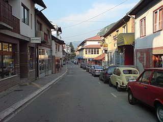
Prijepolje is a town and municipality located in the Zlatibor District of southwestern Serbia. As of 2011 census, the town has 13,330 inhabitants, while the municipality has 37,059 inhabitants.
Serbia, officially the Republic of Serbia, is a country situated at the crossroads of Central and Southeast Europe in the southern Pannonian Plain and the central Balkans. The sovereign state borders Hungary to the north, Romania to the northeast, Bulgaria to the southeast, North Macedonia to the south, Croatia and Bosnia and Herzegovina to the west, and Montenegro to the southwest. The country claims a border with Albania through the disputed territory of Kosovo. Serbia's population is about seven million. Its capital, Belgrade, ranks among the oldest and largest citiеs in southeastern Europe.
Mašková is a village and municipality in the Lučenec District in the Banská Bystrica Region of Slovakia.
Trstené pri Hornáde is a village and municipality in Košice-okolie District in the Kosice Region of eastern Slovakia.
Gmina Klucze is a rural gmina in Olkusz County, Lesser Poland Voivodeship, in southern Poland. Its seat is the village of Klucze, which lies approximately 7 kilometres (4 mi) north of Olkusz and 41 km (25 mi) north-west of the regional capital Kraków.
Melinești is a commune in Dolj County, Romania with a population of 4,392 people. It is composed of thirteen villages: Bodăiești, Bodăieștii de Sus, Godeni, Melinești, Muierușu, Negoiești, Odoleni, Ohaba, Ploștina, Popești, Spineni, Valea Mare and Valea Muierii de Jos.
Bity Kamień is a village in the administrative district of Gmina Dąbrowa Białostocka, within Sokółka County, Podlaskie Voivodeship, in north-eastern Poland. It lies approximately 10 kilometres (6 mi) south of Dąbrowa Białostocka, 22 km (14 mi) north-west of Sokółka, and 52 km (32 mi) north of the regional capital Białystok.
Moșnița Nouă is a commune in Timiș County, Romania, founded in 1902 by ethnic Hungarian settlers from Békés County and Szentes. It is composed of five villages: Albina (Bródpuszta), Moșnița Nouă, Moșnița Veche (Mosnica), Rudicica (Ruzicskatelep) and Urseni (Magyarmedves).
Vădăstrița is a commune in Olt County, Romania. It is composed of a single village, Vădăstrița.
Bistra is a village in northeastern Bulgaria, in the Targovishte Municipality of the Targovishte Province.
Mala Reka is a village in the municipality of Bajina Bašta, Serbia. According to the 2002 census, the village has a population of 489 people.
Donja Bela Reka is a village in the municipality of Nova Varoš, western Serbia. According to the 2002 census, the village has a population of 287 people.
Draglica is a village in the municipality of Nova Varoš, western Serbia. According to the 2002 census, the village has a population of 257 people.
Oina is a village in Muhu Parish, Saare County in western Estonia.
Milatkoviće is a village in the municipality of Raška, Serbia. According to the 2002 census, the village has a population of 161 people.
Zarevo, Serbia is a village in the municipality of Raška, Serbia. According to the 2002 census, the village has a population of 71 people.
Batkovići is a village in the municipality of Priboj, Serbia. According to the 2002 census, the village has a population of 153 people.
Crnuzi is a village in the municipality of Priboj, Serbia. According to the 2002 census, the village has a population of 445 people.
Zabrđe is a village in the municipality of Priboj, Serbia. According to the 2002 census, the village has a population of 350 people.
Živinice is a village in the municipality of Priboj, Serbia. According to the 2002 census, the village has a population of 118 people.
Čauševići is a village in the municipality of Prijepolje, Serbia. According to the 2002 census, the village has a population of 132 people.
Kozmodemyansk is the name of several inhabited localities in Russia.
Coordinates: 43°20′N19°34′E / 43.333°N 19.567°E
A geographic coordinate system is a coordinate system that enables every location on Earth to be specified by a set of numbers, letters or symbols. The coordinates are often chosen such that one of the numbers represents a vertical position and two or three of the numbers represent a horizontal position; alternatively, a geographic position may be expressed in a combined three-dimensional Cartesian vector. A common choice of coordinates is latitude, longitude and elevation. To specify a location on a plane requires a map projection.
This Zlatibor District, Serbia location article is a stub. You can help Wikipedia by expanding it. |