Karridene

Last updated
Karridene
South Africa KwaZulu-Natal location map.svg
Red pog.svg
Karridene
South Africa adm location map.svg
Red pog.svg
Karridene
Coordinates: 30°08′S30°50′E / 30.133°S 30.833°E / -30.133; 30.833 Coordinates: 30°08′S30°50′E / 30.133°S 30.833°E / -30.133; 30.833
Country South Africa
Province KwaZulu-Natal
Municipality eThekwini
Main Place Kingsburgh
Area
[1]
  Total0.78 km2 (0.30 sq mi)
Population
(2011) [1]
  Total73
  Density94/km2 (240/sq mi)
Racial makeup (2011)
[1]
   Black African 19.2%
   Coloured 11.0%
   Indian/Asian 13.7%
   White 56.2%
First languages (2011)
[1]
   Zulu 56.2%
   English 31.2%
   Afrikaans 12.5%
Time zone UTC+2 (SAST)
Postal code (street)
4126

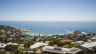
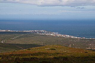
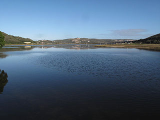
Karridene is a small resort in KwaZulu-Natal, South Africa. It is now part of eThekwini. Seaside resort at the mouth of the Umzimbaza River, 37 km south-west of Durban, between Illovo Beach and Umkomaas.

KwaZulu-Natal Province of South Africa

KwaZulu-Natal is a province of South Africa that was created in 1994 when the Zulu bantustan of KwaZulu and Natal Province were merged. It is located in the southeast of the country, enjoying a long shoreline beside the Indian Ocean and sharing borders with three other provinces and the countries of Mozambique, Eswatini and Lesotho. Its capital is Pietermaritzburg and its largest city is Durban. It is the 2nd most populous province in South Africa, with slightly fewer residents than Gauteng.

South Africa Republic in the southernmost part of Africa

South Africa, officially the Republic of South Africa (RSA), is the southernmost country in Africa. It is bounded to the south by 2,798 kilometres (1,739 mi) of coastline of Southern Africa stretching along the South Atlantic and Indian Oceans; to the north by the neighbouring countries of Namibia, Botswana, and Zimbabwe; and to the east and northeast by Mozambique and Eswatini (Swaziland); and it surrounds the enclaved country of Lesotho. South Africa is the largest country in Southern Africa and the 25th-largest country in the world by land area and, with over 57 million people, is the world's 24th-most populous nation. It is the southernmost country on the mainland of the Old World or the Eastern Hemisphere. About 80 percent of South Africans are of Sub-Saharan African ancestry, divided among a variety of ethnic groups speaking different African languages, nine of which have official status. The remaining population consists of Africa's largest communities of European (White), Asian (Indian), and multiracial (Coloured) ancestry.

eThekwini Metropolitan Municipality Metropolitan municipality in KwaZulu-Natal, South Africa

eThekwini Metropolitan Municipality is a metropolitan municipality created in 2000, that includes the city of Durban, South Africa and surrounding towns. eThekwini is one of the 11 districts of KwaZulu-Natal province of South Africa. The majority of its 3,442,361 people speak Zulu. It was formed from seven formerly independent local councils and tribal land.

Contents

History

Named after Lieutenant-Colonel Walter Karri-Davis, a mining magnate and owner of the ground where it was laid out. [2]

See also

Related Research Articles

Doonside, KwaZulu-Natal Place in KwaZulu-Natal, South Africa

Doonside is a small coastal resort on the banks of the Little Manzimtoti River in KwaZulu-Natal, South Africa. It is now part of eThekwini.

Kingsburgh, KwaZulu-Natal Place in KwaZulu-Natal, South Africa

Kingsburgh is a resort town in KwaZulu-Natal, South Africa, 32 km south-west of Durban.

Umzumbe Place in KwaZulu-Natal, South Africa

Umzumbe is a seaside resort situated at the mouth of the Mzumbe River (bad kraal) in KwaZulu-Natal, South Africa. The name of the river is derived from a band of Hlongwa cannibals who occupied the valley. The Hlongwa was almost wiped out by the Zulu king Shaka in 1828.

Bela-Bela Place in Limpopo, South Africa

Bela-Bela is a town in the Limpopo Province of South Africa. Deriving its name from the geothermic hot springs around which the town was built, it was called Warmbaths, until 2002.

Great Fish River river in South Africa

The Great Fish River is a river running 644 kilometres (400 mi) through the South African province of the Eastern Cape. The coastal area between Port Elizabeth and the Fish River mouth is known as the Sunshine Coast. The Great Fish River was originally named Rio do Infante, after João Infante, the captain of one of the caravels of Bartolomeu Dias. Infante visited the river in the late 1480s.

Aliwal North Place in Eastern Cape, South Africa

Aliwal North is a town in central South Africa on the Orange River, Eastern Cape Province. Aliwal North is the seat of the Walter Sisulu Local Municipality within the Joe Gqabi District Municipality.

Llandudno, Cape Town Place in Western Cape, South Africa

Llandudno is a residential suburb of Cape Town, South Africa, on the Atlantic seaboard of the Cape Peninsula. There are no street lights, shops or commercial activities, and the suburb has some of the most expensive residential property in South Africa.

Chintsa Place in Eastern Cape, South Africa

Chintsa is a village in the Wild Coast region of the Eastern Cape province, South Africa. It is situated 38 km north-east from East London, at the mouth of the Cintsa river.

De Kelders Place in Western Cape, South Africa

De Kelders is a coastal village in the Overberg District Municipality, Western Cape, South Africa.

Infanta, Western Cape Place in Western Cape, South Africa

Infanta is a settlement in Overberg District Municipality in the Western Cape province of South Africa.

Herolds Bay Place in Western Cape, South Africa

Herolds Bay is a settlement in Garden Route District Municipality in the Western Cape province of South Africa.

Little Brak River (town) Place in Western Cape, South Africa

Little Brak River is a settlement in Garden Route District Municipality in the Western Cape province of South Africa.

Port Beaufort Place in Western Cape, South Africa

Port Beaufort is a settlement in Garden Route District Municipality in the Western Cape province of South Africa.

Nkandla Local Municipality Local municipality in KwaZulu-Natal, South Africa

Nkandla Local Municipality is an administrative area in the uThungulu District of KwaZulu-Natal province in South Africa. The town of Nkandla is the home town of the former President of South Africa, Jacob Zuma.

Umbogintwini Place in KwaZulu-Natal, South Africa

Umbogintwini is a town near Durban in KwaZulu-Natal, South Africa. Its post office received the corrected name in 1997. It is best known for the industrial complex which has Acacia, Chemical Initiatives and Sammar warehouses.

Anerley, KwaZulu-Natal Place in KwaZulu-Natal, South Africa

Anerley is a town in Ugu District Municipality in the KwaZulu-Natal province of South Africa.

Illovo, KwaZulu-Natal Place in KwaZulu-Natal, South Africa

Illovo is a town in EThekwini in the KwaZulu-Natal province of South Africa.

Tshipise Place in Limpopo, South Africa

Tshipise is a town in Vhembe District Municipality in the Limpopo province of South Africa.

Black December

Black December refers to at least nine shark attacks on humans causing six deaths that occurred along the coast of KwaZulu-Natal, South Africa, from December 18, 1957 to April 5, 1958.

Strandfontein, Cape Town Place in Western Cape, South Africa

Strandfontein is a seaside resort 8 km east of Muizenberg, on the northern shore of False Bay in the City of Cape Town municipality in the Western Cape province of South Africa.

References

  1. 1 2 3 4 "Sub Place Karridene". Census 2011.
  2. "Dictionary of Southern African Place Names (Public Domain)". Human Science Research Council. p. 242.