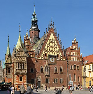
Żary County is a unit of territorial administration and local government (powiat) in Lubusz Voivodeship, western Poland, on the German border. It came into being on January 1, 1999, as a result of the Polish local government reforms passed in 1998. Its administrative seat and largest town is Żary, which lies 43 km (27 mi) south-west of Zielona Góra and 123 km (76 mi) south of Gorzów Wielkopolski. The county contains three other towns: Lubsko, lying 21 km (13 mi) north-west of Żary, Jasień, lying 16 km (10 mi) north-west of Żary, and Łęknica, 30 km (19 mi) west of Żary.

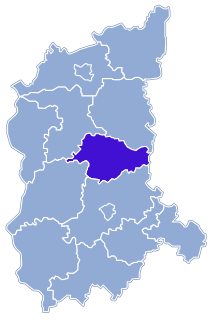
Zielona Góra County is a unit of territorial administration and local government (powiat) in Lubusz Voivodeship, western Poland. It came into being on January 1, 1999, as a result of the Polish local government reforms passed in 1998. Its administrative seat is the city of Zielona Góra, although the city is not part of the county. The county contains five towns: Sulechów, which lies 18 km (11 mi) north-east of Zielona Góra, Nowogród Bobrzański, which lies 25 km (16 mi) south-west of Zielona Góra, Babimost, which lies 32 km (20 mi) north-east of Zielona Góra, Czerwieńsk, which lies 11 km (7 mi) north-west of Zielona Góra, and Kargowa, 29 km (18 mi) north-east of Zielona Góra.
Świebodzin County is a unit of territorial administration and local government (powiat) in Lubusz Voivodeship, western Poland. It came into being on January 1, 1999, as a result of the Polish local government reforms passed in 1998. Its administrative seat and largest town is Świebodzin, which lies 35 km (22 mi) north of Zielona Góra and 57 km (35 mi) south of Gorzów Wielkopolski. The only other town in the county is Zbąszynek, lying 20 km (12 mi) east of Świebodzin.

Krosno Odrzańskie County is a unit of territorial administration and local government (powiat) in Lubusz Voivodeship, western Poland, on the German border. It came into being on January 1, 1999, as a result of the Polish local government reforms passed in 1998. Its administrative seat is the town of Krosno Odrzańskie, which lies 30 km (19 mi) west of Zielona Góra and 79 km (49 mi) south of Gorzów Wielkopolski. The only other town in the county is Gubin, situated on the German border 28 km (17 mi) west of Krosno Odrzańskie.

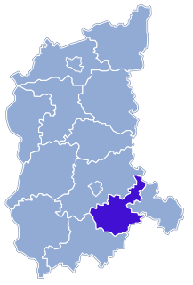
Żagań County is a unit of territorial administration and local government (powiat) in Lubusz Voivodeship, western Poland. It came into being on January 1, 1999, as a result of the Polish local government reforms passed in 1998. Its administrative seat and largest town is Żagań, which lies 39 km (24 mi) south of Zielona Góra and 124 km (77 mi) south of Gorzów Wielkopolski. The county contains four other towns: Szprotawa, lying 14 km (9 mi) south-east of Żagań, Iłowa, lying 15 km (9 mi) south-west of Żagań, Małomice, lying 12 km (7 mi) south-east of Żagań, and Gozdnica, 25 km (16 mi) south-west of Żagań.

Wschowa County is a unit of territorial administration and local government (powiat) in Lubusz Voivodeship, western Poland. It was created in 2002 out of three gminas which previously belonged to Nowa Sól County. Its administrative seat and largest town is Wschowa, which lies 57 km (35 mi) east of Zielona Góra and 126 km (78 mi) south-east of Gorzów Wielkopolski. The county also contains the towns of Sława, lying 18 km (11 mi) north-west of Wschowa, and Szlichtyngowa, 10 km (6 mi) south of Wschowa.
Nowa Sól County is a unit of territorial administration and local government (powiat) in Lubusz Voivodeship, western Poland. It came into being on January 1, 1999, as a result of the Polish local government reforms passed in 1998. Its administrative seat and largest town is Nowa Sól, which lies 22 km (14 mi) south-east of Zielona Góra and 109 km (68 mi) south of Gorzów Wielkopolski. The county contains three other towns: Kożuchów, lying 10 km (6 mi) south-west of Nowa Sól, Bytom Odrzański, lying 11 km (7 mi) south-east of Nowa Sól, and Nowe Miasteczko, 13 km (8 mi) south of Nowa Sól.

Piaseczno County is a unit of territorial administration and local government (powiat) in Masovian Voivodeship, east-central Poland. It came into being on January 1, 1999, as a result of the Polish local government reforms passed in 1998. Its administrative seat and largest town is Piaseczno, which lies 17 kilometres (11 mi) south of Warsaw. The county contains three other towns: Konstancin-Jeziorna, 8 km (5 mi) east of Piaseczno, Góra Kalwaria, 18 km (11 mi) south-east of Piaseczno, and Tarczyn, 16 km (10 mi) south-west of Piaseczno.

Brzeżany is a village in the administrative district of Gmina Góra, within Góra County, Lower Silesian Voivodeship, in south-western Poland. Prior to 1945 it was in Germany.
Glinka is a village in the administrative district of Gmina Góra, within Góra County, Lower Silesian Voivodeship, in south-western Poland. Prior to 1945 it was in Germany.
Gola Górowska is a village in the administrative district of Gmina Góra, within Góra County, Lower Silesian Voivodeship, in south-western Poland. Prior to 1945 it was in Germany.
Jastrzębia is a village in the administrative district of Gmina Góra, within Góra County, Lower Silesian Voivodeship, in south-western Poland. Prior to 1945 it was in Germany.
Ryczeń is a village in the administrative district of Gmina Góra, within Góra County, Lower Silesian Voivodeship, in south-western Poland. Prior to 1945 it was in Germany.
Stara Góra is a village in the administrative district of Gmina Góra, within Góra County, Lower Silesian Voivodeship, in south-western Poland. Prior to 1945 it was in Germany.
Chorągwice is a village in the administrative district of Gmina Jemielno, within Góra County, Lower Silesian Voivodeship, in south-western Poland.
Lubów is a village in the administrative district of Gmina Jemielno, within Góra County, Lower Silesian Voivodeship, in south-western Poland. Prior to 1945 it was in Germany.
Czeladź Wielka is a village in the administrative district of Gmina Wąsosz, within Góra County, Lower Silesian Voivodeship, in south-western Poland. Prior to 1945 it was in Germany.
Drozdowice Małe is a village in the administrative district of Gmina Wąsosz, within Góra County, Lower Silesian Voivodeship, in south-western Poland. Prior to 1945 it was in Germany.
Drozdowice Wielkie is a village in the administrative district of Gmina Wąsosz, within Góra County, Lower Silesian Voivodeship, in south-western Poland. Prior to 1945 it was in Germany.
Gmina Kobyla Góra is a rural gmina in Ostrzeszów County, Greater Poland Voivodeship, in west-central Poland. Its seat is the village of Kobyla Góra, which lies approximately 12 kilometres (7 mi) west of Ostrzeszów and 130 km (81 mi) south-east of the regional capital Poznań.