Kasbe Tadawale

Last updated

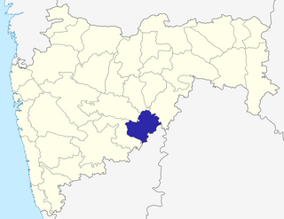
Kasbe Tadawale is a village in the Osmanabad District in Maharashtra, India. This village has a weekly market which attracts locals from surrounding villages. It also has a railway station named Kallam Road. The station was thus named because passengers originally took this route to Kallam, one of the tehsils in the Osmanabad district.

Maharashtra State in western India

Maharashtra is a state in the western peninsular region of India occupying a substantial portion of the Deccan Plateau. It is the second-most populous state and third-largest state by area in India. Spread over 307,713 km2 (118,809 sq mi), it is bordered by the Arabian Sea to the west, the Indian states of Karnataka and Goa to the south, Telangana to the southeast and Chhattisgarh to the east, Gujarat and Madhya Pradesh to the north, and the Indian union territory of Dadra and Nagar Haveli to the north west. It is also the world's second-most populous subnational entity.

India Country in South Asia

India, officially the Republic of India, is a country in South Asia. It is the seventh-largest country by area, the second-most populous country, and the most populous democracy in the world. Bounded by the Indian Ocean on the south, the Arabian Sea on the southwest, and the Bay of Bengal on the southeast, it shares land borders with Pakistan to the west; China, Nepal, and Bhutan to the north; and Bangladesh and Myanmar to the east. In the Indian Ocean, India is in the vicinity of Sri Lanka and the Maldives; its Andaman and Nicobar Islands share a maritime border with Thailand and Indonesia.

Kallam is an Indian patronymic surname. Notable people with the surname include:

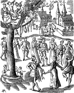
The village celebrates Rama Navami, a nine-day festival which commemorates a number of mythological events.

Rama Navami a spring Hindu festival, birthday of Rama

Rama Navami is a spring Hindu festival that celebrates the birthday of lord Rama. He is particularly important to the Vaishnavism tradition of Hinduism, as the seventh avatar of Vishnu. The festival celebrates the descent of god Vishnu as Rama avatar, through his birth to King Dasharatha and Queen Kausalya in Ayodhya. The festival is a part of the spring Navratri, and falls on the ninth day of the bright half in the Hindu calendar month of Chaitra. This typically occurs in the Gregorian months of March or April every year. Rama Navami is an optional government holiday in India.

Festival Organised series of acts and performances

A festival is an event ordinarily celebrated by a community and centering on some characteristic aspect of that community and its religion or cultures. It is often marked as a local or national holiday, mela, or eid. Next to religion and folklore, a significant origin is agricultural. Food is such a vital resource that many festivals are associated with harvest time. Religious commemoration and thanksgiving for good harvests are blended in events that take place in autumn, such as Halloween in the northern hemisphere and Easter in the southern.

Related Research Articles

Osmanabad District is an administrative district in the Marathwada region in the Indian state of Maharashtra. The district headquarter is located at Osmanabad. The District of Osmanabad derives its name from the last ruler of Hyderabad, the 7th Nizam, Mir Osman Ali Khan, of which the region was a part till 1947. This region was earlier part of The Hyderabad State until Independence.This primarily rural district occupies an area of 7569 km² of which 241.4 km² is urban and has a population of 1,657,576 of which 16.96% were urban.

Osmanabad City in Maharashtra, India

Osmanabad is a city and a municipal council in Osmanabad district in the Indian state of Maharashtra. Osmanabad derives its name from the last ruler of Hyderabad, Mir Osman Ali Khan. Osmanabad city is the administrative headquarter of Osmanabad District.

Latur district District of Maharashtra in India

Latur district is a district in Maharashtra state of India. Latur city is the district headquarters and is the 16th largest city in the state of Maharashtra. The district is primarily agricultural. Urban population comprises 25.47% of the total population.

Tuljapur city in Maharashtra, India

Tuljapur is a town with a municipal council in Osmanabad district in the Indian state of Maharashtra. It is the administrative seat of Tuljapur taluka.

Kurduvadi small town in Maharashtra, India

Kurduvadi is a small town in Solapur district in Maharashtra state of India. It is situated on Barshi Light Railway It is known mainly for the railway junction connecting two different rail tracks. Prior to gauge conversion it used to be a junction with different size gauge tracks.

Paranda village in Maharashtra, India

Paranda is a village with a municipal council in the Osmanabad district of the Indian state of Maharashtra. It is the headquarters town for the Paranda Tehsil.

Umarga Town in Maharashtra, India

Umarga/ Omerga is a town with a municipal council in the Osmanabad district in the Indian state of Maharashtra. It is an administrative headquarter of the Umarga Tehsil.

Vairag village in Maharashtra, India

Vairag is a town in Barshi Taluka of Solapur district in Maharashtra, India. The village is located centrally between Solapur and Barshi.

Kalamb, Osmanabad town in Maharashtra, India

Kalamb (Kallam) is a town with a municipal council in Osmanabad district in the Indian state of Maharashtra. Administratively it is part of and headquarters for the Kalamb Tahsil.

Kalamb Tahsil tehsil in Maharashtra, India

Kallamb is one of eight tehsils in the Osmanabad district in the state of Maharashtra, India. Headquarters for the tehsil is the town of Kalamb. There are ninety-one panchayat villages in the Kalamb Tehsil.

Washi, Osmanabad Small city in Maharashtra, India

Washi is a Nagar panchayat village and the headquarters of Washi taluka in Bhoom subdivision of Osmanabad district of Maharashtra state in India. The village of Washi is 22 km by road northeast of the town of Bhoom, and 25 km by road northwest of Yermala. The nearest railway station is 40 km by road southwest to Yedshi in Osmanabad District.

Mankeshwar village in Maharashtra, India

Mankeshwar is a panchayat village in Bhoom Tehsil, Osmanabad district of Maharashtra, India. It is known for its Shiva temple and Goddess Satwai Devi temple.

Osmanabad railway station

Osmanabad is a railway station situated on Latur road junction – Miraj junction route of central railway.

Osmanabad, Golestan village in Golestan, Iran

Osmanabad is a village in Gorganbuy Rural District, in the Central District of Aqqala County, Golestan Province, Iran. At the 2006 census, its population was 315, in 62 families.

Lohara Tahsil tehsil in Maharashtra, India

Lohara Tahsil is a tahsil/taluka (subdistrict) in Osmanabad district, Maharashtra on the Deccan Plateau of India. Lohara Bk. is the administrative headquarters of the tahsil. There are forty-five panchayat villages in Lohara Taluka.

Lohara Bk. village in Maharashtra, India

Lohara Bk. is a panchayat village in the state of Maharashtra, India. Lohara Bk. is headquarters for and administratively under Lohara Tahsil of Osmanabad District in Maharashtra. There is only the single village of Lohara Bk. in the Lohara (BK) gram panchayat. The village of Lohara Bk. is 22 km by road west of the village of Sastur and 37 km by road east of the town of Tuljapur.

Naldurg Fort

Naldurg Fort is a historic fort in Naldurg town of Osmanabad district in Maharashtra state of India. Naldurg fort is named after Nalraja who built the fort in medieval architectural style. The unique feature of the fort is that it encloses a knoll of basalt rock which juts out into the valley of the small Bori River and with a long fortification wall with many bastions.

Borda is a small village in Osmanabad district in the state of Maharashtra, India. It is 9 km from Kallam, the tehsil office of Borda.

Dahitane village in Maharashtra, India

Dahitane is a village in Barshi Taluka of Solapur district in Maharashtra, India. The village is located between Town Vairag and Tehsil Mohol. Dahitane is a village panchayat located in the Solapur district of Maharashtra state, India. The latitude 18.0079127 and longitude 75.7683995 are the geocoordinate of the Dahitane. Mumbai is the state capital for Dahitane village. It is located around 328.5 kilometer away from Dahitane. The other nearest state capital from Dahitane is Hyderabad and its distance is 295.1 km. The other surrounding state capitals are Hyderabad 295.1 km, Daman 408.8 km, Bangalore 591.6 km.

Yenegur Village in Maharashtra, India

Yenegur is a major village located in Omerga tehsil of Osmanabad district, which is part of the Marathwada region of the state of Maharashtra in India.