This article needs to be updated.(July 2021) |
Kasoa Interchange is an ongoing project to ease the vehicular congestion on the Accra-Cape Coast highway. [1] [2] [3] [4]
This article needs to be updated.(July 2021) |
Kasoa Interchange is an ongoing project to ease the vehicular congestion on the Accra-Cape Coast highway. [1] [2] [3] [4]
The project has been divided into three phases. In all, a new 33 kilometer Kasoa-Oboum road will be constructed. There will be an interchange constructed at the Kasoa Junction. The project also includes a two 12-classroom blocks, 12-unit classroom blocks, one polyclinic with all accessories, 10 mechanized bore-holes, and 20 kilometers of local roads would be constructed around Kasoa area, as well as a walk-over at Iron City. [5]

The National Roads and Motorways in Greece constitute the main road network of the country. These two types of roads are distinct in terms of their construction specifications. Their main difference is that motorways adhere to higher quality construction standards than National Roads.

The Metropolitan Rapid Transit or MRT is a mass rapid transit system serving the Bangkok Metropolitan Region in Thailand. The MRT system comprises two fully operational rapid transit lines. One monorail line is in trial operation, with a further two lines under construction. The MRT Blue Line, officially the Chaloem Ratchamongkhon Line, between Hua Lamphong and Bang Sue was the first to open in 2004 as Bangkok's second metro system. The MRT Blue line is officially known in Thai as rotfaifa mahanakhon (รถไฟฟ้ามหานคร) or "metropolitan electric train", but it is more commonly called rotfai taidin (รถไฟใต้ดิน), literally, "underground train" as it was distinguished by the BTS Skytrain as being completely underground, when its first section between Hua Lamphong to Bang Sue opened.
The South Luzon Expressway (SLEX), signed as E2 of the Philippine expressway network and R-3 of the Metro Manila arterial road network, is a limited-access toll expressway that connects Metro Manila to the provinces in the Calabarzon region on the island of Luzon in the Philippines. The expressway has a length of 49.56 km, traveling from its northern terminus at the Magallanes Interchange in Makati to its southern terminus at Santo Tomas, Batangas, connecting it to the Southern Tagalog Arterial Road. A portion of the expressway from the Magallanes Interchange to the Calamba Exit is part of Asian Highway 26 of the Asian highway network.
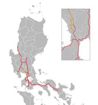
The North Luzon Expressway (NLEX), signed as E1 of the Philippine expressway network, partially as N160 of the Philippine highway network, and R-8 of the Metro Manila arterial road network, is a limited-access toll expressway that connects Metro Manila to the provinces of the Central Luzon region in the Philippines. The expressway, which includes the main segment and its various spurs, has a total length of 101.8 kilometers (63.3 mi) and travels from its northern terminus at Sta. Ines Interchange to its southern terminus in Balintawak Interchange, which is adjacent to its connection to Skyway, an elevated toll road that connects the NLEX to its counterpart in the south, the South Luzon Expressway. The segment of the expressway between Santa Rita Exit in Guiguinto and the Balintawak Interchange in Quezon City is part of Asian Highway 26 of the Asian highway network.
Contraflow lane reversal is the altering of the normal flow of traffic, typically on a controlled-access highway, to either aid in an emergency evacuation or, as part of routine maintenance activities, to facilitate widening or reconstruction of one of the highway's carriageways.

Located directly east of the Korle Lagoon, Jamestown and Usshertown are the oldest districts of Accra, Ghana and emerged as communities around the 17th century British James Fort and Dutch Ussher Fort on the Gulf of Guinea coast. These districts were developed at the end of the 19th century, and following the rapid growth of the city during the 20th century, they became areas of a dense mixture of commercial and residential use.
The Dutch A15 motorway is a set of two motorways in the Netherlands, the A15 and the A18.

Ayawaso West or Ayawaso West Wuogon is one of the constituencies in Accra represented in the Parliament of Ghana. It elects one Member of Parliament (MP) by the first past the post system of election. Ayawaso West is located in the Accra Metropolitan Area of the Greater Accra Region of Ghana.
The Ninoy Aquino International Airport Expressway (NAIAX), signed as E6 of the Philippine expressway network, is an 11.6-kilometer (7.2 mi) elevated expressway in Metro Manila, Philippines, which links the Skyway to Ninoy Aquino International Airport and Entertainment City. Traversing the cities of Taguig, Pasay, and Parañaque, the NAIAX runs along Andrews Avenue, Electrical Road, and NAIA Road connecting the Skyway to Ninoy Aquino Avenue, Macapagal Boulevard, New Seaside Drive and the Manila–Cavite Expressway.

Roads in Ghana form a network of varied quality and capacity. Responsibility for the road network differs between trunk and non-trunk routes. Trunk roads, which are the most important roads, are administered by the Ghana Highway Authority, which was established in 1974 to develop the trunk road network. Ghana's 13,367 km of trunk roads accounts for 33% of the total road network of 40,186 km. The Department of Feeder Roads is responsible for the construction and maintenance of feeder roads in Ghana, while responsibility for urban roads lies with the Department of Urban Roads. In the 18th and 19th centuries, the Ashanti Empire constructed a complex network of roads to link Kumasi with their territories in modern Ghana. For John Thornton, these roads improved transportation across the region by the 19th century.

Kasoa, formerly known as Odupongkpehe, is a peri-urban town in the Awutu Senya East Municipal District of the Central region of Ghana.

The Tetteh Quarshie Interchange is a cloverleaf interchange carrying a six-lane motorway that links the Liberation Road from 37 Military Hospital to the Pantang junction through Madina in Accra, Ghana. The interchange was commissioned for vehicular use on 27 February 2005 by then president of Ghana, John Agyekum Kufuor.
The Ako-Adjei Interchange is a flyover in Accra, Ghana. Until 2005 it was known as the Sankara Interchange. The construction of interchange started in September 1997 and ended in December 1999. It was constructed during the Jerry Rawlings administration and was the first interchange to be built in Ghana.
Kwame Nkrumah Interchange is a 3-tier interchange which was constructed to replace the Kwame Nkrumah Circle in the centre of the city of Accra, Ghana. It opened in 2016. The interchange is named in honour of Ghana's first president, Kwame Nkrumah, who was the leading figure during the country's fight for independence from Britain. Both the current and the old edifices remain iconic landmarks of Ghana's capital city, Accra.
The N1 or National Highway 1 is a national highway in Ghana that begins at the border with Ivory Coast at Elubo and runs through Sekondi-Takoradi, Cape Coast, Winneba, Accra and Tema to the border with Togo at Aflao. It is the main highway along the coast of the country, with a total distance of 540 kilometers. The route runs through the Western, Central, Greater Accra and Volta regions of Ghana.

Mavis Hawa Koomson is a Ghanaian politician and educationist. She is the Member of Parliament for Awutu Senya East Constituency and doubles as the Minister of Special Development Initiatives. She was appointed by President of Ghana Nana Akuffo-Addo on 10 January 2017 as Minister of Special Development Initiatives.
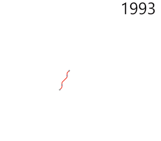
This article lists the openings of lines, line segments, stations and fare schemes of the Shanghai Metro, a rapid transit system serving Shanghai, China, and one of the fastest-growing metro systems in the world. The first section opened in 1993, and the system currently has 802 kilometres (498 mi) of track in operation, making it one of the world's largest rapid transit systems by route length and second largest by number of stations.
The Ramadan Cup is an annual football competition played between May and June depending on the Ramadan calendar of the year within the Muslim Ramadan season.
Okyereko is a town near Winneba Junction in the Gomoa East District in the Central Region of Ghana. It is located along the Kasoa-Winneba road on the Cape Coast-Accra Highway.