
Krishnadevaraya was an emperor of the Vijayanagara Empire reigning from 1509 to 1529. He was the third monarch of the Tuluva dynasty, and is considered to be one of the greatest rulers in Indian history. He ruled the largest empire in India after the fall of the Islamic Delhi Sultanate. Presiding over the empire at its zenith, he is regarded as an icon by many Indians. Krishnadevaraya earned the titles Andhra Bhoja, Karnatakaratna Simhasanadeeshwara, Yavana Rajya Pratistapanacharya, Kannada Rajya Rama Ramana, Gaubrahmana Pratipalaka and Mooru Rayara Ganda. He became the dominant ruler of the peninsula by defeating the sultans of Bijapur, Golconda, the Bahmani Sultanate and the Gajapatis of Odisha, and was one of the most powerful Hindu rulers in India.

Chandragiri is a suburb and neighbourhood of Tirupati and located in Tirupati district of the Indian state of Andhra Pradesh. It is a part of Tirupati urban agglomeration and a major growing residential area in Tirupati It is the mandal headquarters of Chandragiri mandal in Tirupati revenue division. It also falls in the jurisdictional limit of Tirupati Urban Development Authority. Chandragiri is the southwestern entrance of Tirupati for vehicles coming from Bangalore, Kerala and Tamil Nadu. Kalyana Venkateswara Temple, Srinivasamangapuram is located next to Chandragiri through which well-laid stone footpaths called Srivari Mettu are available to reach Tirumala on foot.

Hassan is one of the 31 districts of Karnataka, India. The district headquarter is Hassan. It was part of Manjarabad Faujdari a.k.a. Patnada Rayada between 1832-81. In 1882, it was reduced into a sub-division under erstwhile Kadur district. But in 1886, the Hassan district was restored to its current form.

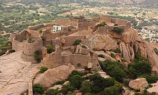
Chitradurga is a city and the headquarters of Chitradurga district, which is located on the valley of the Vedavati river in the central part of the Indian state of Karnataka. Chitradurga is a place with historical significance and a major tourist hub of Karnataka. The city is renowned for its 15th century Kallina Kote or Stone Fortress. This is formed of two Kannada words: ‘Kallina’ means "Stone's" and Kote means "Fort". Other names used in Kannada are ‘Ukkina Kote": "Steel Fort" and ‘Yelusuttina Kote’: "Seven Circles Fort".

Davanagere district is an administrative district of Karnataka state in India. It is the centre of Karnataka. The city of Davanagere is the district headquarters. It had a population of 1,643,494 of which 32.31% was urban as of 2011. This district was separated from Chitradurga district in 1997 by the then Chief minister of Karnataka J. H. Patel including Chennagiri and Honali Taluks Shimoga district.
Nayakas of Chitradurga (1588–1779) were an Indian dynasty that ruled parts of eastern Karnataka during the post-Vijayanagara period, centered at Chitradurga. During the rule of the Hoysala Empire and the Vijayanagara Empire, they served as a feudatory chiefdom. Later, after the fall of the Vijayanagara Empire, they ruled at times as an independent chiefdom and at other times as a vassal of the Mysore Kingdom, Mughal Empire and Maratha Empire. Their territories merged into the Kingdom of Mysore under British rule.

Nayakas of Keladi (1499–1763), also known as Nayakas of Bednore and Ikkeri Nayakas, were an Indian dynasty based in Keladi in present-day Shimoga district of Karnataka, India. They were an important ruling dynasty in post-medieval Karnataka. They initially ruled as a vassal of the famous Vijayanagar Empire. After the fall of the empire in 1565, they gained independence and ruled significant parts of Malnad region of the Western Ghats in present-day Karnataka, most areas in the coastal regions of Karnataka and the central plains along the Tungabhadra river. In 1763 AD, with their defeat to Hyder Ali, they were absorbed into the Kingdom of Mysore. They played an important part in the history of Karnataka, during a time of confusion and fragmentation that generally prevailed in South India after the fall of the Vijayanagar Empire. The Keladi rulers were of the Vokkaliga and Banajiga castes and were Veerashaivas by faith. The Haleri Kingdom that ruled over Coorg between 1600 A.D and 1834 A.D. was founded by a member of the Keladi family.

Ikkeri is a hamlet situated in Sagara taluk (township) about 6 km to the south of the town centre in Sagara. It is known for the Aghoreshvara Temple, dedicated to an avatar of Shiva. The word Ikkeri in Kannada means "two streets".
Sira is a city and taluk headquarters of Sira Taluk of Tumkur district in the state of Karnataka, India. It lies on the AH 47, NH 48. It is the second largest city in the district after the headquarters by population, area and economy. It is the fastest developing city in the district. The State Capital city, Bengaluru, is 120 km from Sira. It is known for its historical significance as a political and military center and for being the capital of Imperial Sira Subah in the early 1700s.
Sira is a taluk of Tumkur district in the state of Karnataka, India. Its headquarters, Sira city lies on the NH 48 .It is the largest taluk in district by area.Second largest in population and economy.It is most developed regions in district after headquarters.

Chikkaballapura district is a district in the state of Karnataka, India. On 23 August 2007, it was carved out of the pre-existing Kolar district which was the fourth largest district of Karnataka by moving the talukas of Gauribidanur, Gudibanda, Bagepalli, Chikballapur, Manchenahalli, Chelur, Sidlaghatta and Chintamani into the new district. Kannada is the official language.

The political history of the region on the Deccan Plateau in west-central peninsular India that was later divided into Mysore state and Coorg province saw many changes after the fall of the Hindu Vijayanagara Empire in 1565. The rise of Sultan Haidar Ali in 1761 introduced a new period.
Uchangidurga is a main Holy & Historical village/town in Harapanahalli Taluk of Vijayanagara District in Karnataka, India. It is 29km away from both Harapanahalli and Davanagere, it is located on state highway 47 & it comes under Harapanahalli taluk of Vijayanagara district in Karnataka.

The Kunchitigas are a community of people from Karnataka, India. They are mostly concentrated in the Tumkur, Bangalore, Mysore, Ramanagara, Shivamogga and Chitradurga districts. They are also found in Tamil Nadu.

Durgaastamana is a 1982 historical novel by the Kannada novelist and scholar T. R. Subba Rao, popularly known as TaRaSu. As the name indicates, the book charts the downfall of the Nayakas of Chitradurga, a dynasty that ruled there for two centuries. The story follows the epic battle between Madakari Nayaka and Hyder Ali of Mysore in 1779, as the latter lays siege to the fort, and the events and political intrigues leading up to it.
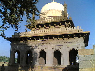
Malik Rihan Dargah, also known as Malik Rihan tomb, is a mausoleum in Sira, Karnataka, India. It contains the grave of Malik Rihan who was the governor of Sira province in the 17th-century. It has a square plan and illustrates the Indo-Saracenic style in Deccan architecture.
Arikadi Fort is a fort located in the Kasaragod district of Kerala, India. It is also known as Kumbla Fort. The fort is located at a distance of 1 km from Kumbla on the NH 66 National Highway between kumbala River and shiriya River There is a Hanuman temple just below the fort.

Ratnagiri Fort is a hill fort located in the Ratnagiri village near Rolla, in Sri Sathya Sai district of Andhra Pradesh, India. Located near the border of Andhra Pradesh and Karnataka in the Rayalaseema region, it is also known as Seema Golconda. The Government of India has designated it as a Monument of National Importance.
Madakasira Fort, also known as Simhagiri, is a hill fort located in the Madakasira town of Sri Sathya Sai district, in Andhra Pradesh, India. The Government of India has designated it as a Monument of National Importance.
Randaula Khan, also spelt Ranadulla Khan, was a leading Indo-African general and viceroy of the Bijapur Sultanate during the 17th century. He governed the southwestern region of the Sultanate from his administrative seat at Mirjan. He was a key player in the Sultanate's politics, particularly during Mughal-Bijapur conflicts in the early 17th century. He is remembered for leading conquests that expanded Bijapur southwards into the Karnataka region in the mid-17th century.
