
Kataba is a town located in the Western Province of Zambia. Its original name was Kataba Masamba. It is in the Mulobezi District. [1] [2]
Kataba is a town located in the Western Province of Zambia. Its original name was Kataba Masamba. It is in the Mulobezi District. [1] [2]

The Arctic Archipelago, also known as the Canadian Arctic Archipelago, is an archipelago lying to the north of the Canadian continental mainland, excluding Greenland and Iceland.

The Nimrod Glacier is a major glacier about 135 km (85 mi) long, flowing from the polar plateau in a northerly direction through the Transantarctic Mountains into the Ross Ice Shelf, Antarctica.
Skelton Glacier is a large glacier flowing from the polar plateau into the Ross Ice Shelf at Skelton Inlet on the Hillary Coast, south of Victoria Land, Antarctica.

Ferrar Glacier is a glacier in Antarctica. It is about 35 nautical miles long, flowing from the plateau of Victoria Land west of the Royal Society Range to New Harbour in McMurdo Sound. The glacier makes a right (east) turn northeast of Knobhead, where it where it is apposed, i.e., joined in Siamese-twin fashion, to Taylor Glacier. From there, it continues east along the south side of Kukri Hills to New Harbor.

The Lukasashi River is a tributary of the Lunsemfwa River in Zambia. It flows through important game conservation areas along its course.

The Quartermain Mountains are a group of exposed mountains in Antarctica, about 20 nautical miles long, typical of ice-free features of the McMurdo Dry Valleys, Victoria Land. They are located south of Taylor Glacier and bounded by Finger Mountain, Mount Handsley, Mount Feather and Tabular Mountain; also including Knobhead, Terra Cotta Mountain, New Mountain, Beacon Heights, Pyramid Mountain, Arena Valley, Kennar Valley, Turnabout Valley and the several valleys and ridges within Beacon Valley.
The Northumberland Islands are a scattered island chain off the eastern coast of Queensland, Australia.
The Allan Hills are a group of hills, mainly ice free and about 12 nautical miles long, lying just north-west of the Coombs Hills near the heads of Mawson Glacier and Mackay Glacier in the Oates Land and Victoria Land regions of Antarctica.
Vohitromby is a town and commune in Madagascar. It belongs to the district of Farafangana, which is a part of Atsimo-Atsinanana Region. The population of the commune was estimated to be approximately 5,000 in 2001 commune census.
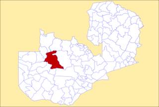
Mufumbwe District is a district of Zambia, located in North-Western Province. The capital lies at Mufumbwe. As of the 2000 Zambian Census, the district had a population of 71,238 people.
The Mbarara–Kikagati Road is in southwestern Uganda, connecting the city of Mbarara in Mbarara District and the town of Kikagati in Isingiro District, at the border between Uganda and Tanzania. The road continues into Tanzania as Highway B182.
On the continent of Antarctica, the Aramis Range is the third range south in the Prince Charles Mountains, situated 11 miles southeast of the Porthos Range and extending for about 30 miles in a southwest–northeast direction. It was first visited in January 1957 by Australian National Antarctic Research Expeditions (ANARE) southern party led by W.G. Bewsher, who named it for a character in Alexandre Dumas' novel The Three Musketeers, the most popular book read on the southern journey.

The history of rail transport in Zambia began at the start of the twentieth century.
Andi Jemma Airport is an airport near Masamba, the capital city of North Luwu Regency in the province of South Sulawesi on the island of Sulawesi in Indonesia.
Grantham Island is an uninhabited island occupying 51 hectares of Proper Bay, Spencer Gulf, South Australia. The nearest geographical feature on the mainland is Murray Point, which is also undeveloped. The island was named by explorer Matthew Flinders on 25 February 1802, after the municipal and parliamentary borough of Grantham, Lincolnshire, England. It lies 3 kilometres south of the Port Lincoln marina and is well vegetated.

Chitambo District is a district of Central Province, Zambia. It was separated from Serenje District in 2012 and is located some 357km north-east of Kabwe along the Great North Road. It shares borders with Serenje, Samfya, Lavushimanda and the Democratic Republic of Congo.
Neolebias lozii, the banded neolebias, is a species of freshwater ray-finned fish within the family Distichodontidae. It is found in Africa within Zambia, inhabiting the tributary of the Kataba River, the Sianda stream, and a small tributary system in upper Zambia that joins the eastern side of the Barotse Floodplain. The species inhabits small streams near seasonally flooded plains that are bordered by open woodlands, living under dense floating mats of vegetation and emergent vegetation. It feeds on small aquatic invertebrates and grows to a length of 1.8 centimetres (0.71 in).
| | This Zambia location article is a stub. You can help Wikipedia by expanding it. |