
Gujarat is a state along the western coast of India. Its coastline of about 1,600 km (990 mi) is the longest in the country, most of which lies on the Kathiawar peninsula. Gujarat is the fifth-largest Indian state by area, covering some 196,024 km2 (75,685 sq mi); and the ninth-most populous state, with a population of 60.4 million in 2011. It is bordered by Rajasthan to the northeast, Dadra and Nagar Haveli and Daman and Diu to the south, Maharashtra to the southeast, Madhya Pradesh to the east, and the Arabian Sea and the Pakistani province of Sindh to the west. Gujarat's capital city is Gandhinagar, while its largest city is Ahmedabad. The Gujaratis are indigenous to the state and their language, Gujarati, is the state's official language.
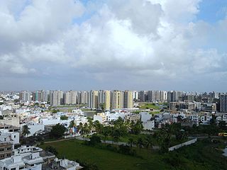
Surat is a city in the western Indian state of Gujarat. The word Surat directly translates to face in Urdu, Gujarati and Hindi. Located on the banks of the river Tapti near its confluence with the Arabian Sea, it used to be a large seaport. It is now the commercial and economic centre of South Gujarat, and one of the largest urban areas of western India. It has well-established diamond and textile industry, and is a major supply centre for apparels and accessories. About 90% of the world's diamonds are cut and polished in Surat. It is the second largest city in Gujarat after Ahmedabad and the eighth largest city by population and ninth largest urban agglomeration in India. It is the administrative capital of the Surat district.
Bhavnagar is a city and the headquarters of Bhavnagar district in the Indian state of Gujarat. It was founded in 1723 by Bhavsinhji Gohil. It was the capital of Bhavnagar State, which was a princely state before it was merged into the Indian Union in February 1948.
Amreli district is one of the 33 administrative districts of the state of Gujarat in western India. The district headquarters are located at Amreli. The district occupies an area of 6,760 km2 and has a population of 1,514,190 of which 22.45% were urban. Amreli is the land of Yogiji Maharaj (Dhari), Dan Bapu (Chalala), Sage Muldas, Sage Bhojalram Bapa, Sage Muktanand Swami, Magician K.Lal, Zaverchand Meghani's place (Bagasara), Dr. Jivaraj Mehta etc. Amreli covers Dhari Gir National forest sanctuary area. Now it is developing as a Hub of Education.

Navsari is an administrative district in the state of Gujarat in India, with its headquarters at the city of Navsari. The district covers an area of 2,211 square kilometres and was formed in 1997 after Valsad district was split into Valsad and Navsari districts. It is the largest producer of chikoos in India.

The Tapi river is the longest river in southern Thailand. The river originates at Khao Luang mountain in Nakhon Si Thammarat Province, and empties into the Gulf of Thailand at Bandon Bay near the town of Bandon. It has a length of 230 kilometres (140 mi).

Amreli is a city and a municipality in Amreli district in Indian state of Gujarat.

Surat is a district in the state of Gujarat, city as the administrative headquarters of this district. It is surrounded by Bharuch, Narmada (North), Navsari (South) districts and east Tapi district To the west is the Gulf of Cambay. It is the second-most advanced district in Gujarat. It had a population of 6,081,322 of which 79.68% were urban as of 2011. On 2 October 2007 Surat district was split into two by the creation of a new Tapi district, under the Surat District Re-organisation Act 2007.
Songadh is a taluka in Tapi district in the Indian state of Gujarat.
Ukai is a census town in Tapi district in the Indian state of Gujarat.
Bapunagar in Ahmedabad, Gujarat, India. It is in the eastern part of the city, in the Bpunagr ward. Its name derives from the word bapu, which refers to Gandhi, who was popularly called bapu, or 'father'.

South Gujarat, also known as Dakshin Gujarat, is a region in the Indian state of Gujarat. The region has a wetter climate than other regions of Gujarat. The western part is almost coastal and is known as Kantha Vistar, and the eastern part is also known as Dungar Vistar, which ranges from 100 to 1000 metres, with the highest peak at Saputara in the Dang district.

Gujarat is a state located in western India. Its north-western border, which is also the international border, is adjacent to Pakistan. Rajasthan and Madhya Pradesh are the states located in its north and north-east respectively. Maharashtra is to its south. The Arabian Sea forms its western-southern boundary. Dadar and Nagar-Haveli are on its southern border.

Mandvi is a town located in the Mandvi tehsil of Surat District, Gujarat state, India and lies on the banks of the Tapti River. It is around 61 kilometres (38 mi) east of Surat.
Rander is a town in Surat district in the state of Gujarat, India. Located on the bank of the Tapti River, it is 2 kilometres (1.2 mi) from the city of Surat.

Surat Diamond Bourse (SDB) is a diamond trade centre located in DREAM City, Surat, Gujarat, India, designed by the architecture firm Morphogenesis. It is the world's largest diamond trading hub with a floor space of 660,000 square metres (7,100,000 sq ft), as well as the world's largest office building. The current Chairman is Govind Dholakia and CEO of Surat Diamond Bourse is Mahesh Gadhavi.

Gopi Talav or Gopi Lake is a lake in the Gopipura locality in the city of Surat in Gujarat state of India. It was built circa 1510 CE by Malik Gopi, who was an affluent merchant and governor of Surat during the Gujarat Sultanate. In 2012, the lake was renovated by Surat Municipal Corporation and the area surrounding redeveloped as a recreational facility.

Laljibhai Patel is an Indian diamantaire, philanthropist, social activist, and the chairman of Dharmanandan Diamonds (DDPL). He has been the head of Dharmanandan Diamonds for over four and a half decades.
Morarji Desai Setu is a weir-cum-causeway on the Tapi River in Surat, Gujarat, India. It connects Rander and Katargam neighbourhoods. It was built in 1995 at an approximate cost of ₹35 crore.
