
Airdrie is a town in North Lanarkshire, Scotland. It lies on a plateau 400 ft above sea level, 12 miles (19 km) east of Glasgow. As of 2012, it had a population of 37,130. Airdrie developed as a market town in the late 17th century following an Act of Parliament allowing it to hold a weekly market. It later grew in prominence as a centre for weaving and manufacturing, as well as being the settlement near several coalmines. In the mid 19th century, the town expanded greatly as a result of immigration and the development of iron works and railway links. This led to the town building the first public library in Scotland in 1853. During the 20th century, industrial decline took place in Airdrie, with heavy industry closing down across much of the town. In the 21st century, Airdrie has continued as a regional centre for services and retail, as well as being a commuter settlement within the Central Belt. Historically part of Lanarkshire, Airdrie forms a conurbation with its neighbour Coatbridge, in what was formerly the Monklands district, with a population of approximately 90,000.

Lanarkshire, also called the County of Lanark, is a historic county, lieutenancy area and registration county in the Central Lowlands and Southern Uplands of Scotland. The county is no longer used for local government purposes, but gives its name to the two modern council areas of North Lanarkshire and South Lanarkshire.

Motherwell is a town and former burgh in North Lanarkshire, Scotland, United Kingdom, south east of Glasgow. It has a population of around 32,120. Historically in the parish of Dalziel and part of Lanarkshire, Motherwell is the headquarters for North Lanarkshire Council. Geographically the River Clyde separates Motherwell from Hamilton to the west whereas the South Calder Water separates Motherwell from Carfin to the north-east and New Stevenston and Bellshill towards the north.
Wishaw is a large town in North Lanarkshire, Scotland, on the edge of the Clyde Valley, 15 miles (24 km) south-east of Glasgow city centre.

Cleland is a village near Motherwell and Wishaw in North Lanarkshire, Scotland,. As of 2018, it has a population of about 3,000. The village has a strong coal mining heritage, and is a typical example of a working class village in North Lanarkshire and the Glasgow area. Due to its location, despite being at the heart of North Lanarkshire, the village is isolated, geographically and culturally, from surrounding towns such as Motherwell, Shotts and Wishaw.

Fauldhouse is a village in West Lothian, Scotland. It is about halfway between Glasgow and Edinburgh. The nearest towns to Fauldhouse are Whitburn and Livingston. Other neighbouring villages include Longridge, Shotts and Stoneyburn. At approximately 750 feet above sea level, Fauldhouse is one of the highest villages in West Lothian.

Harthill is a rural village split between North Lanarkshire and West Lothian in Scotland, with most of the village in North Lanarkshire. It is located about halfway between Glasgow, 21 miles to the west, and Edinburgh, 25 miles (40 km) to the east. It lies on the River Almond about 2+1⁄2 miles (4 km) west of the small town of Whitburn. The closest major towns are Bathgate, 6 miles (9.7 km) away, and Livingston, 10 miles (16 km) away. Major towns within North Lanarkshire, such as Wishaw, Airdrie, Motherwell, Coatbridge and Bellshill are all around 10 to 15 miles to the west. The M8 motorway bypasses the village and Harthill has a service station named after it.

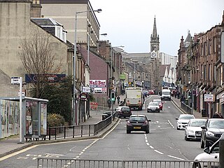
Shotts is a small town in North Lanarkshire, Scotland. It is located almost halfway between Glasgow and Edinburgh. The town has a population of about 8,840. A local story has Shotts being named after the legendary giant highwayman Bertram de Shotts, though toponymists give the Anglo-Saxon scēots as the real source of the name. Shotts is the home of the world famous Shotts and Dykehead Caledonia Pipe Band, 16-time winners of World Pipe Band Championships.

The Battle of Drumclog was fought on 1 June 1679, between a group of Covenanters and the forces of John Graham of Claverhouse, at Drumclog, in South Lanarkshire, Scotland.

Burnside is a mostly residential area in the town of Rutherglen in South Lanarkshire, Scotland. Including the neighbourhoods of High Burnside and High Crosshill, respectively south and north-west of its main street, it borders Overtoun Park in Rutherglen plus several other residential areas of the town, as well as western parts of neighbouring Cambuslang.

The Diocese of Motherwell is a Latin Church ecclesiastical territory or diocese of the Catholic Church in Scotland.
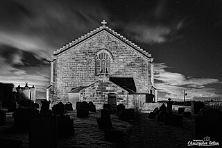
Shottskirk, more commonly known as Kirk O'Shotts Parish Church, or affectionately "The M8 Church", is a local parish church located in Salsburgh, North Lanarkshire, Scotland, and serves the village of Salsburgh, the town of Shotts and the hamlets in between. The last dedicated minister for this church was Rev. Sheila Spense who retired in 2000.
The History of Cambuslang is explained to a great deal by its geography. Now in South Lanarkshire, the town of Cambuslang is an ancient part of Scotland where Iron Age remains loom over 21st century housing developments. It has been very prosperous over time, depending first upon its agricultural land, then the mineral resources under its soil.
Bertram de Shotts is known locally as a legendary giant that roamed the then village of Shotts, Scotland in the 15th century. Shotts was then a dreary moorland place on the Great Road of the Shire. The road was an important route for tradesmen carrying their wares around Scotland. Bertram de Shotts habitually savaged packmen and peddlers for treasure carried along the Great Road. Such was the menace of Bertram de Shotts, King James IV of Scotland ordered his death. Bertram de Shotts was probably in fact seven or eight feet high, yet nonetheless, his presence merited Giant status.
Salsburgh is a semi-rural former coal mining village in greenbelt farmland within the district of North Lanarkshire, Scotland. The closest major towns to the village are Shotts, three miles southeast, and Airdrie three miles northwest.
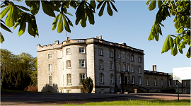
Murdostoun is an estate in North Lanarkshire, Scotland, which includes a castle, which lies on the South Calder Water near the village of Bonkle in the parish of Shotts, North Lanarkshire, Scotland. The name Murdostoun was derived from the words Murthock and Toun which meant dwelling of Murthock. Murdostoun can refer to the ancient barony of the Scott and then the Inglis clan, the castle built by the Scotts or a bridge over the South Calder Water.
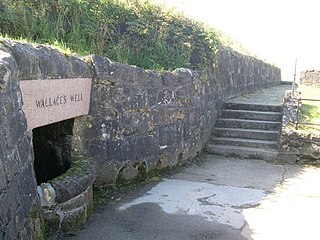
Wallace's Well or Auchinleck Well is a historic well which in present times is a monument and tourist attraction, located on Langmuirhead Road near Robroyston in the Glasgow City council area, Scotland. William Wallace is said to have drunk from the well whenever he visited the area and also just before his capture by English troops commanded by Sir John Mentieth.

Broomhouse is a residential area in Glasgow, Scotland. It is about six miles east of the city centre. Historically a small mining village and later the site of the Glasgow Zoo, in the early 21st century it grew substantially as an affluent commuter suburb.

Drumclog is a small village in South Lanarkshire, Parish of Avendale and Drumclog, Scotland. The settlement is situated on the A71, between Caldermill and Priestland in East Ayrshire at an elevation of 197 metres and about five miles west of Strathaven.
It was the early 2000s, and Emma and I would spend hours driving around, just the two of us, exploring the area with no particular destination in mind. One of our favourite stops was Kate’s Well. I remember Emma’s car – or, as we lovingly called it, “Fix It Again Tony,” that old Fiat – making its way down the road, tires humming against the pavement as we pulled up to collect water from that well in our empty coke bottles.
But not every trip was smooth sailing. One day, in the middle of nowhere, the Fiat broke down. Of course, we were stranded. The car wouldn’t start, and we had no choice but to wait for help. like magic, the police showed up. They weren’t exactly thrilled about having to push the car, but there we were, sitting in the front seats, laughing hysterically. It must have looked ridiculous, but we couldn’t stop. As soon as the car finally roared to life, Emma let out a joyful toot of the horn. Those police couldn’t see us for dust as we sped off, the sound of our laughter fading into the distance.

