A narrow-gauge railway is a railway with a track gauge narrower than standard 1,435 mm. Most narrow-gauge railways are between 600 mm and 1,067 mm.

OO9 is a model railway scale and gauge combination of 4 mm scale and 9 mm gauge tracks, which models a prototype track gauge of 2 ft 3 in. It is a common choice in the United Kingdom for the modelling of narrow-gauge railways whose prototype gauges lie approximately between 2 ft and 2 ft 6 in. The 9 mm track gauge is used by N gauge model railways, a common commercial scale, which means that a selection of wheels and mechanisms is readily available.
HOn30 gauge is the modelling of narrow-gauge railways in HO on N gauge track in 1:87 scale ratio.

On30gauge is the modelling of narrow gauge railways in O scale on HO gauge track in 1:48 scale ratio by American model railroaders, in 1:43.5 scale ratio by British and French model railroaders and 1:45 by Continental European model railroaders.

The Kalka–Shimla railway is a 2 ft 6 in narrow-gauge railway in North India which traverses a mostly-mountainous route from Kalka to Shimla. It is known for dramatic views of the hills and surrounding villages. The railway was built under the direction of Herbert Septimus Harington between 1898 and 1903 to connect Shimla, the summer capital of India during the British Raj, with the rest of the Indian rail system.

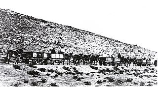
The Ferrocarril de Antofagasta a Bolivia is a private railway operating in the northern provinces of Chile. It is notable in that it was one of the earliest railways built to 2 ft 6 in narrow gauge, with a route that climbed from sea level to over 4,500 m (14,764 ft), while handling goods traffic totaling near 2 million tons per annum. It proved that a railway with such a narrow gauge could do the work of a standard gauge railway, and influenced the construction of other railways such as the Estrada de Ferro Oeste de Minas. It was later converted to 1,000 mmmetre gauge, and still operates today.
The Tyers Valley Tramway was a 2 ft 6 in narrow gauge timber tramway built by the Forests Commission of Victoria to exploit timber resources on the slopes of Mount Baw Baw, Victoria. At Collins Siding the tramway linked with the Victorian Railways narrow gauge line from Moe to Walhalla, and was built to the same 2 ft 6 in gauge.
Everard Richard Calthrop was a British railway engineer and inventor. Calthrop was a notable promoter and builder of narrow-gauge railways, especially of 2 ft 6 in narrow gauge, and was especially prominent in India. His most notable achievement was the Barsi Light Railway; however he is best known in his home country for the Leek and Manifold Valley Light Railway. Calthrop has been described as a "railway genius". Later in life he took an interest in aviation, patenting some early designs for parachutes.
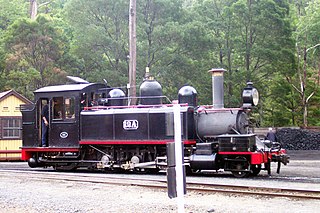
The Victorian Railways NA class was a 2-6-2 tank locomotive built for their 2 ft 6 in gauge branch lines.
Martin's Light Railways (MLR) consisted of seven narrow-gauge railway lines in the states of West Bengal, Bihar, and Uttar Pradesh in India. The railways were built and owned by Martin & Co., which was a British company.

Barsi Light Railway (BLR) was a 202-mile (325 km) long, 2 ft 6 in narrow-gauge railway between Miraj and Latur in the state of Maharashtra in India. It was the brainchild of British engineer Everard Calthrop, and regarded as having revolutionised narrow-gauge railway construction in India.
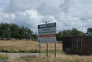
RNAD Broughton Moor is a decommissioned Royal Naval Armaments Depot located between Great Broughton and Broughton Moor in the County of Cumbria, England.
The Khulna–Bagerhat Railway was a 2 ft 6 in narrow gauge railway in Bangladesh. It was constructed in 1918, and was dismantled in the 1980s. 20-mile (32 km) long, in 1958 it had five 2-4-0t steam locomotives, 13 coaches, and 8 freight cars.
The Jessore–Jhenidah Light Railway was a 29-mile-long (47 km) 2 ft 6 in narrow gauge railway in British India, now in Bangladesh. It was constructed in 1913, and was dismantled in 1969. It operated 0-4-4T, 0-6-2T, 2-4-0T, and 0-8-0T locomotives of mostly German manufacture. The railway developed a reputation for being poorly managed, an official report in 1915 states that staff could not nominate one person as their manager.
The Namaqualand Railway was a 2 ft 6 in narrow gauge railway operating between Port Nolloth and O'okiep in the Namaqualand region of the former Cape Colony in South Africa. It was originally a mule-drawn railway built to provide an outlet for the copper mines of the region. Constructed between 1869 and 1876, the railway was 93 1⁄2 miles long, with an additional 8 miles purely associated with the copper mine workings. Although owned by the Cape Copper Company, the railway always operated as a public railway.

Bengal Provincial Railway was a 2 ft 6 in narrow-gauge railway from Tarakeswar to Magra, in Indian state of West Bengal.

Abraham 'Abram' Fitzgibbon was an Irish-born railroad engineer and a pioneer for narrow-gauge railways.

The South African Railways Class NG1 0-4-0T of 1900 was a narrow-gauge steam locomotive from the pre-Union era in Transvaal.
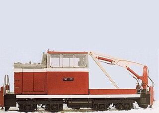
The TU8G (ТУ8Г) is a Soviet, later Russian diesel locomotive for track gauge 750 mm.
McLeod’s Light Railways (MLR) consisted of following four 2 ft 6 in narrow-gauge lines in West Bengal in India. The railways were built and owned by McLeod & Company, which was the subsidiary of a London company of managing agents, McLeod Russell & Co. Ltd. On 1 July 1967, MLR was merged with South Eastern Railway.