New Ireland Province, formerly New Mecklenburg, is the most northeastern province of Papua New Guinea.
Papua New Guinea, officially the Independent State of Papua New Guinea is a country in Oceania that occupies the eastern half of the island of New Guinea and its offshore islands in Melanesia, a region of the southwestern Pacific Ocean north of Australia. Its capital, located along its southeastern coast, is Port Moresby. The western half of New Guinea forms the Indonesian provinces of Papua and West Papua.
New Ireland or Latangai, is a large island in Papua New Guinea, approximately 7,404 km2 (2,859 sq mi) in area with ca. 120,000 people. It is the largest island of New Ireland Province, lying northeast of the island of New Britain. Both islands are part of the Bismarck Archipelago, named after Otto von Bismarck, and they are separated by Saint George's Channel. The administrative centre of the island and of New Ireland province is the town of Kavieng located at the northern end of the island. While the island was part of German New Guinea, it was named Neumecklenburg.
Kavieng is the capital of the Papua New Guinean province of New Ireland and the largest town on the island of the same name. The town is located at Balgai Bay, on the northern tip of the island. As of 2009, it had a population of 17,248.
The Kavieng Urban LLG is a local government area in New Ireland Province, Papua New Guinea. The LLG is located in Kavieng District and the LLG headquarters is Kavieng. This LLG has six wards. The area is a renowned habitat for the Nutrias or giant rats. Population is 16,725(Census 2011) and the Lord Mayor is Hon. Stanley Mansini MPA.
The Lavongai Rural LLG is a local government area in New Ireland Province, Papua New Guinea. The LLG administers the island of New Hanover and a few surrounding islands. The LLG is located in Kavieng District and the LLG headquarters is Taskul. Some population centres in the LLG are: Taskul, Patiagaga, Patipai, Ungakum, Tsoi, Tukulisava, and Ungalik. This LLG has 19 wards, comprising a population of 29,005. Current LLG President is John Aini.
The Star Mountains Rural LLG is a local level government situated in the Star Mountains in the North Fly District of the Western Province of Papua New Guinea. In the year 2000, the LLG had 1691 homes, and a population of 12,114 people. The current population is more likely to now be around 15,000 people. The main population centre in the LLG is Tabubil. Finalbin and the Ok Tedi Mine are also in this LLG.
The Olsobip Rural LLG is a local level government situated in the North Fly District of the Western Province of Papua New Guinea. In the year 2000, the LLG was the least populous of the district, with a population of only 3851 people. The capital of the LLG is a station town by the name of Olsobip.
The Kiunga Rural LLG is a local level government area situated in the North Fly District of the Western Province of Papua New Guinea. In the year 2000, the LLG had a population of 13,249 people. The township of Kiunga is within the boundaries of this LLG, but has its own urban LLG.
The Middle Fly District of the Western Province of Papua New Guinea is a large, coastal district that forms the central area of the Fly River basin. It contains the Local-Level Government areas of: Balimo Urban, Bamu Rural, Gogodaia Rural, Lake Murray Rural, and Nomad Rural, and the population centres of Balimo, Bamu, Gogodala and Nomad. It also contains the largest lake in the country, Lake Murray.
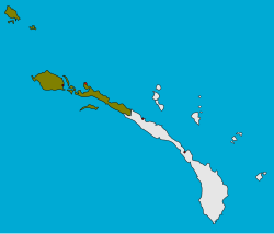
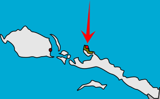
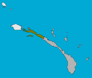
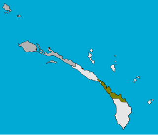
The Tikana Rural LLG is a local government area in New Ireland Province, Papua New Guinea. The LLG administers the northern section of the island of New Ireland, as well as Djaul Island and some Tigak islands in the strait between New Ireland and New Hanover.
The Murat Rural LLG is a local government area in New Ireland Province, Papua New Guinea. The LLG president is Herman Sole. The LLG administers the St. Matthias Group of islands and is located in Kavieng District. Population is 4,210(Census 2011).
Namatanai District is the southernmost and larger of the two districts of New Ireland Province in Papua New Guinea. The district covers the southern part of the island of New Ireland, as well as the Tabar Group, the Lihir Group, the Tanga Islands and the Feni Islands.
The Namatanai Rural LLG is a local government area in New Ireland Province, Papua New Guinea. The LLG is located in Namatanai District and the LLG headquarters is Namatanai.
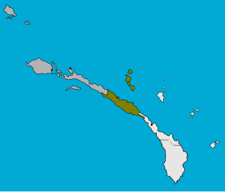
The Sentral Niu Ailan Rural LLG is a local government area in New Ireland Province, Papua New Guinea. The LLG administers the central area of the island of New Ireland especially the people of Barok, Mandak, Kuot, Notsi and the Tabar Group. The LLG is located in Namatanai District and the LLG headquarters is Konos.
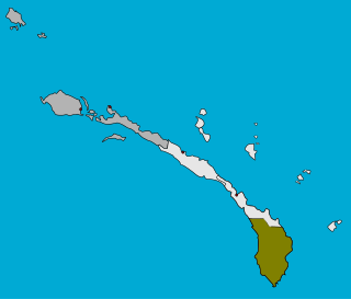
The Konoagil Rural LLG is a local government area in New Ireland Province, Papua New Guinea. The LLG administers the southern peninsula of the island of New Ireland. The LLG is located in Namatanai District and its population is 10,503(Census 2011). Languages in the area are Siar-Lak language, Kandas language, and Label language.
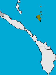
The Nimamar Rural LLG is a local government area in New Ireland Province, Papua New Guinea. The LLG administers the Lihir Group of islands. The LLG is located in Namatanai District and contains the Lihir Gold Mine, which is the second largest gold deposit in the world. Main language spoken here is the Lihir language. Many speakers of other languages are present here due to the mining on the island. Commonly are Niwer Mil language, Kuanua language and Mandara language.
This page is a list of districts of Papua New Guinea.
Chuave is a Trans–New Guinea language of Chimbu Province and Eastern Highlands Province, Papua New Guinea.
Mekinley Island is an island north of Sariba Island, and on the eastern side of China Strait, in Milne Bay Province, Papua New Guinea.
Matalai Rural LLG was created from Wards 15-21 in the Namatanai Rural LLG and Wards 1-2 of Konoagil Rural LLG in the Namatanai district of New Ireland. It is located in the South East Coast of New Ireland Province. It has a population of 12,393 as of the 2011 PNG National Census. The current LLG President is Augustine Topi. Languages spoken here are Sursurunga language, Fanamaket language and Konomala language.
Tanga people are a tribe of Papua New Guinea that lives in the Tanga Islands and Feni Islands of Tanir Rural LLG and three villages in the Matalai Rural LLG of Namatanai District of New Ireland Province. The people are closely related to the Tolai people and Sursurunga people of New Ireland and they speak the Tangga language which has since been split into three separate languages which are now spoken by the Tangans. These languages are: Niwer Mil, Warwar Feni and Fanamaket. Their population according to the 2011 Papua New Guinea Census Report is 12,466 people. Tubuan, Sokapana and Ingiet are the secret societies practised by the Tanga people. F.L.S. Bell has a collection on Tanga Islands in the University of Sydney Library in Australia.
This page is based on this Wikipedia article Text is available under the CC BY-SA 4.0 license; additional terms may apply. Images, videos and audio are available under their respective licenses.