The Triassic is a geologic period and system which spans 50.6 million years from the end of the Permian Period 251.9 million years ago (Mya), to the beginning of the Jurassic Period 201.3 Mya. The Triassic is the first and shortest period of the Mesozoic Era. Both the start and end of the period are marked by major extinction events.

The Dharug National Park is a protected national park that is located in the Central Coast region of New South Wales, in eastern Australia. The 14,850-hectare (36,700-acre) national park is situated approximately 58 kilometres (36 mi) north of the Sydney central business district and 25 kilometres (16 mi) west of Gosford.

The Hunter Region, also commonly known as the Hunter Valley, is a region of New South Wales, Australia, extending from approximately 120 km (75 mi) to 310 km (193 mi) north of Sydney. It contains the Hunter River and its tributaries with highland areas to the north and south. Situated at the northern end of the Sydney Basin bioregion, the Hunter Valley is one of the largest river valleys on the NSW coast, and is most commonly known for its wineries and coal industry.

Glossopteris is the largest and best-known genus of the extinct order of seed ferns known as Glossopteridales. The genus Glossopteris refers only to leaves, within a framework of form genera used in paleobotany. These are important because they indicate biological identity of these plants that were critical for recognizing former connections between the various fragments of Gondwana: South America, Africa, India, Australia, New Zealand, and Antarctica.

The Sydney Basin is an interim Australian bioregion and is both a structural entity and a depositional area, now preserved on the east coast of New South Wales, Australia and with some of its eastern side now subsided beneath the Tasman Sea. The basin is named for the city of Sydney, on which it is centred.

The geology of Australia includes virtually all known rock types and from all geological time periods spanning over 3.8 billion years of the Earth's history. Australia is a continent situated on the Indo-Australian Plate.
The Hunter-Bowen Orogeny was a significant arc accretion event in the Permian and Triassic periods affecting approximately 2,500 km of the Australian continental margin.

Cladophlebis is an extinct genus of fern which grew during the late Paleozoic and Mesozoic eras. It was a common plant during that time in both the northern and southern hemispheres, and belonged to the order of plants called Filicales.

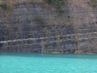
The Narrabeen group of sedimentary rocks occurs in the Sydney Basin in eastern Australia. This series of rocks was formed in the Triassic Period.

Edna Pauline Plumstead was a South African palaeobotanist, of the Bernard Price Institute for Palaeontological Research, University of the Witwatersrand, Johannesburg, where she graduated in 1924. Edna lived in Cape Town the first seven years of her life and that is where she would explore and find wild flowers in the Cape Peninsula. Plumstead would later on connect the wild flowers to the same one in places like Australia and South America when she would later on defend the continental drift. She first began defending the theory of continental drift in the 1950s and has been described as one 'of South Africa's foremost scientists in the field of Gondwana paleobotany and geology'. Plumstead was awarded the Chrestian Mica Gondwanaland Medal by the Geological Society of India, and was made a Fellow of the Royal Society of South Africa.
Geologically the Australian state of New South Wales consists of seven main regions: Lachlan Fold Belt, the Hunter-Bowen Orogeny or New England Orogen (NEO), the Delamerian Orogeny, the Clarence Moreton Basin, the Great Artesian Basin, the Sydney Basin, and the Murray Basin.
The Coal Measures Group is a lithostratigraphical term coined to refer to the coal-bearing succession of rock strata which occur in the United Kingdom within the Westphalian Stage of the Carboniferous Period. Other than in Northern Ireland the term is now obsolete in formal use and is replaced by the Pennine Coal Measures Group, Scottish Coal Measures Group and the South Wales Coal Measures Group for the three distinct depositional provinces of the British mainland.

The geology of Queensland can be subdivided into several regions with different histories. Along the east coast is a complex of Palaezoic to Cainozoic rocks while much of the rest of the state is covered by Cretaceous and Cainozoic rocks. A Precambrian basement is found in the north west and Cape York regions. The Thomson Orogen occurs in the central and southern parts of Queensland, but is mostly covered by younger basins.
The Clarence Moreton Basin is a Mesozoic sedimentary basin on the easternmost part of the Australian continent. It is located in the far north east of the state of New South Wales around Lismore and Grafton and in the south east corner of Queensland. It is the part of the Great Artesian Basin that extends to the east coast in Australia's central eastern lowlands.

The coal measures is a lithostratigraphical term for the coal-bearing part of the Upper Carboniferous System. The Coal Measures Group consists of the Upper Coal Measures Formation, the Middle Coal Measures Formation and the Lower Coal Measures Formation. The group records the deposition of fluvio-deltaic sediments which consists mainly of clastic rocks interstratified with the beds of coal. In most places, the coal measures are underlain by coarser clastic sequences known as Millstone Grit, of Namurian age. The top of the coal measures may be marked by an unconformity, the overlying rocks being Permian or later in age. In some parts of Britain, however, the Coal Measures grade up into mainly coal-barren red beds of late Westphalian and possibly Stephanian age. Within the Pennine Basin these barren measures are now referred to as the Warwickshire Group, from the district where they achieve their thickest development.

The Rio Bonito Formation is a geological formation of the Paraná and Pelotas Basins of Permian age. It is represented by a succession of cyclic sedimentary packages of sandstones, siltstones and shales which bear extensive deposits of coal that has been extracted since the 19th century. The Rio Bonito Formation was deposited in a coastal environment, formed by rivers, deltas, bays and estuaries with tidal plains, barrier islands and shallow marine platform, at a time when the Paraná Basin was a large gulf of the ancient supercontinent Gondwana. This gulf was open to the southwest, to the old ocean Panthalassa. The Rio Bonito Formation outcrops occur mainly in the eastern border of the Paraná Basin, in a narrow band in the states of São Paulo, Paraná, Santa Catarina, Rio Grande do Sul and Uruguay. The Rio Bonito Formation belongs to the second-order stratigraphic supersequence called Gondwana I.
The Doswell Formation is a geologic unit of Upper Triassic age, part of the Newark Supergroup. The Doswell Formation was originally named to refer to a geological sequence which forms the lower part of the sedimentary fill of the Taylorsville Basin in Virginia and Maryland. This sequence was deposited by lakes and rivers in the developing rift basin. However, a 2016 study determined that several geological layers in Pennsylvania as well as the neighboring Richmond Basin of Virginia also qualified as components of the Doswell Formation.
The geology of Merseyside in northwest England largely consists of a faulted sequence of Carboniferous Coal Measures rocks overlain in the west by younger Triassic and Permian age sandstones and mudstones. Glaciation during the present Quaternary Period has left widespread glacial till as well as erosional landforms. Other post-glacial superficial deposits such as river and estuarine alluvium, peat and blown sand are abundant.
The Clouds Creek, a perennial stream that is part of the Clarence River catchment, is located in the Northern Tablelands region of New South Wales, Australia.
Munmorah Conglomerate is a geologic formation in the Sydney Basin in eastern Australia. This stratum is up to 140 metres thick. Formed in the early-Triassic, it is part of the Narrabeen Group of sedimentary rocks. This formation includes medium to coarse-grained sandstone and conglomerate. With minor amounts of siltstone and claystone. Below the Munmorah Conglomerates are Newcastle Coal Measures, originating from the Permian.
