| Kelly Hall Tarn | |
|---|---|
 Kelly Hall Tarn Location in the Lake District National Park  Kelly Hall Tarn Location in South Lakeland, Cumbria | |
| Location | Cumbria, England |
| Coordinates | 54°19′48″N3°05′43″W / 54.330°N 3.0954°W |
| Type | tarn (lake) |
Kelly Hall Tarn is a pool in Cumbria, England, to the west of Coniston Water. It is located about one km south-south-east of the village of Torver, on Torver Back Common. [1] Its name is said to be derived from a nearby building that has since disappeared. [2] The location offers excellent views of the Old Man of Coniston.
 In autumn
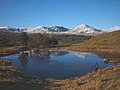 In winter

