The Third Battle of Ypres, also known as the Battle of Passchendaele, was a campaign of the First World War, fought by the Allies against the German Empire. The battle took place on the Western Front, from July to November 1917, for control of the ridges south and east of the Belgian city of Ypres in West Flanders, as part of a strategy decided by the Allies at conferences in November 1916 and May 1917. Passchendaele lies on the last ridge east of Ypres, 5 mi (8 km) from Roulers, a junction of the Bruges-(Brugge)-to-Kortrijk railway. The station at Roulers was on the main supply route of the German 4th Army. Once Passchendaele Ridge had been captured, the Allied advance was to continue to a line from Thourout to Couckelaere (Koekelare).
Heuvelland is a municipality located in the Belgian province of West Flanders. The municipality comprises the villages of Dranouter, Kemmel, De Klijte, Loker, Nieuwkerke, Westouter, Wijtschate and Wulvergem. Heuvelland is a thinly populated rural municipality, located between the small urban centres of Ypres and Poperinge and the metropolitan area of Kortrijk-Lille along the E17. On 1 January 2006 Heuvelland had a total population of 8,217. The total area is 94.24 km2 which gives a population density of 87 inhabitants per km2. The name heuvelland is Dutch meaning "hill country", as the municipality is characterized by the different hills on its territory.
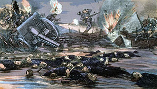
The Battle of the Yser was a battle of the First World War that took place in October 1914 between the towns of Nieuwpoort and Diksmuide, along a 35 km (22 mi) stretch of the Yser River and the Yperlee Canal, in Belgium. The front line was held by a large Belgian force, which halted the German advance in a costly defensive battle.

The Battle of the Lys, also known as the Fourth Battle of Ypres, was fought from 7 to 29 April 1918 and was part of the German spring offensive in Flanders during the First World War. It was originally planned by General Erich Ludendorff as Operation George but was reduced to Operation Georgette, with the objective of capturing Ypres, forcing the British forces back to the Channel ports and out of the war. In planning, execution and effects, Georgette was similar to Operation Michael, earlier in the Spring Offensive.
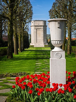
Flanders Field American Cemetery and Memorial is a World War I cemetery in the city of Waregem, Belgium. Originally a temporary battlefield burial ground, Flanders Field American Cemetery later became the only permanent American World War I cemetery in Belgium. The Flanders Field American Cemetery commemorates 411 service members of the United States Armed Forces of which 368 are interred. The Walls of the Missing inside the chapel venerates 43 missing service members.

Gent–Wevelgem, officially Gent–Wevelgem – In Flanders Fields, is a road cycling race in Belgium, held annually since 1934. It is one of the classic races part of the Flemish Cycling Week, run in late March on the last Sunday before the Tour of Flanders.
The Ypres Salient, around Ypres, in Belgium, was the scene of several battles and a major part of the Western Front during World War I.

The Dury Memorial is a World War I Canadian war memorial that commemorates the actions of the Canadian Corps in the Second Battle of Arras, particularly their breakthrough at the Drocourt–Quéant Line switch of the Hindenburg Line just south of the town of Dury, Pas-de-Calais, France.

The Passchendaele Canadian Memorial is a Canadian war memorial that commemorates the actions of the Canadian Corps in the Second Battle of Passchendaele of World War I. The memorial is located on the former site of Crest Farm, an objective captured by the 4th Canadian Division during the assault of 30 October 1917.

The Canadian Hill 62 Memorial is a war memorial that commemorates the actions of the Canadian Corps in defending the southern stretches of the Ypres Salient between April and August 1916 including actions in battle at the St Eloi Craters, Hill 62, Mount Sorrel and Sanctuary Wood. These battles marked the first occasion in which Canadian divisions engaged in planned offensive operations during World War I. In those actions the Canadians reconquered vital high-ground positions that denied the Germans a commanding view of the town of Ypres itself.

Kemmel No. 1 French Cemetery is a Commonwealth War Graves Commission (CWGC) burial ground for the dead of the First World War located in the Ypres Salient on the Western Front.
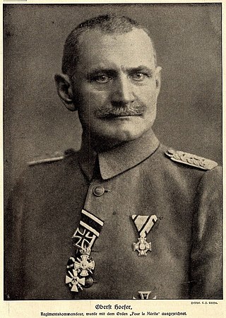
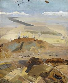
Karl Höfer also Hoefer; was a German general. During World War I he became known as the Held vom Kemmelberge (hero of Kemmel hill) after his division had captured the Kemmelberg during the Fourth Battle of Flanders.
Sint-Elooi is a small village, about 5 km (3.1 mi) south of Ypres in the Flemish province of West Flanders in Belgium. The former municipality is now part of Ypres. Though Sint-Elooi is the Dutch and only official name, the village's French name, St. Eloi, is most commonly used in English due to its role in World War I. The village and the nearby locations of Voormezele and Hollebeke were merged into Zillebeke in 1970 and into Ypres in 1976.

In World War I, the area around Hooge on Bellewaerde Ridge, about 2.5 mi (4 km) east of Ypres in Flanders in Belgium, was one of the easternmost sectors of the Ypres Salient and was the site of much fighting between German and Allied forces.

The Dodengang is a World War I memorial site located near Diksmuide, Belgium. The site is located about 1.5 kilometres (0.93 mi) from the IJzertoren in the centre of the city, and is set directly on the banks of the Yser Canal.

Hill 60 is a World War I battlefield memorial site and park in the Zwarteleen area of Zillebeke south of Ypres, Belgium. It is located about 4.6 kilometres (2.9 mi) from the centre of Ypres and directly on the railway line to Comines. Before the First World War the hill was known locally as Côte des Amants. The site comprises two areas of raised land separated by the railway line; the northern area was known by soldiers as Hill 60 while the southern part was known as The Caterpillar.

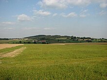
Spanbroekmolen is a small group of farms in Heuvelland, a municipality located in the Belgian province of West Flanders. The hamlet is sited on one of the highest points of the Messines Ridge, in between the villages of Kemmel, Wijtschate and Wulvergem.