Milden is a village in the Canadian province of Saskatchewan within the Rural Municipality of Milden No. 286 and Census Division No. 12. The village is located at the junction of Highway 15 and Highway 655 approximately 20 km west of Outlook on Highway 15.

Hohe Börde was a Verwaltungsgemeinschaft in the Börde district, in Saxony-Anhalt, Germany. It was situated west of Magdeburg. The seat of the Verwaltungsgemeinschaft was in Irxleben. It was disbanded on 1 January 2010.

Fuertescusa is a municipality in Cuenca, Castile-La Mancha, Spain. It has a population of 111.
Torregamones is a municipality located in the province of Zamora, Castile and León, Spain. According to the 2007 census (INE), the municipality has a population of 310 inhabitants. It plays a relative importance in the comarca of Sayago, as a link between Portugal and this zone of the province of Zamora. Apart from Portugal, Torregamones abuts with Villardiegua de la Ribera to the north, Moralina to the east and also Gamones to the south.
Gomunice is a village in Radomsko County, Łódź Voivodeship, in central Poland. It is the seat of the gmina called Gmina Gomunice. It lies approximately 12 kilometres (7 mi) north of Radomsko and 69 km (43 mi) south of the regional capital Łódź.
Majdan Sopocki Drugi is a village in the administrative district of Gmina Susiec, within Tomaszów Lubelski County, Lublin Voivodeship, in eastern Poland. It lies approximately 19 kilometres (12 mi) west of Tomaszów Lubelski and 95 km (59 mi) south-east of the regional capital Lublin.
Wodacz is a village in the administrative district of Gmina Wodzisław, within Jędrzejów County, Świętokrzyskie Voivodeship, in south-central Poland. It lies approximately 5 kilometres (3 mi) south-west of Wodzisław, 20 km (12 mi) south-west of Jędrzejów, and 55 km (34 mi) south-west of the regional capital Kielce.
Podrudzie is a village in the administrative district of Gmina Mińsk Mazowiecki, within Mińsk County, Masovian Voivodeship, in east-central Poland.
Ciechowice is a village in the administrative district of Gmina Nędza, within Racibórz County, Silesian Voivodeship, in southern Poland. It lies approximately 4 kilometres (2 mi) west of Nędza, 10 km (6 mi) north of Racibórz, and 54 km (34 mi) west of the regional capital Katowice.
Chojnica is a village in the administrative district of Gmina Srokowo, within Kętrzyn County, Warmian-Masurian Voivodeship, in northern Poland, close to the border with the Kaliningrad Oblast of Russia. It lies approximately 6 kilometres (4 mi) south-west of Srokowo, 12 km (7 mi) north-east of Kętrzyn, and 78 km (48 mi) north-east of the regional capital Olsztyn.

Hernádpetri is a village in Borsod-Abaúj-Zemplén County in northeastern Hungary.
Caltepec (municipality) is a town and municipality in Puebla in south-eastern Mexico.
Salatse is a village in Haljala Parish, Lääne-Viru County, in northeastern Estonia.
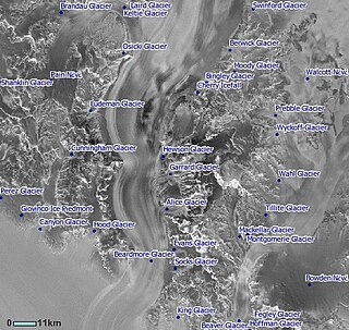
Bingley Glacier is a glacier 8 nautical miles (15 km) long in the Queen Alexandra Range, draining south from the slopes of Mount Kirkpatrick, Mount Dickerson and Barnes Peak and entering Beardmore Glacier just north of the Adams Mountains. It was named by Ernest Shackleton of the British Antarctic Expedition, 1907–09, after Bingley, England, the ancestral home of the Shackleton family.
Coleman Peak is a peak rising to about 1,600 metres (5,250 ft) on the northeast slope of Mount Erebus, Ross Island, 3.6 nautical miles (6.7 km) east of the summit of Fang Ridge. It was named by the New Zealand Geographic Board (2000) after Father John Coleman, a New Zealand chaplain, who traveled to Antarctica many times with the U.S. Antarctic Program.
Fang Ridge is a conspicuous ridge on the northeast slope of Mount Erebus, on Ross Island. It is a much denuded portion of the original caldera rim left by a catastrophic eruption. It was so named, probably for its curved shape, by Frank Debenham of the British Antarctic Expedition, 1910–13, who made a plane table survey in 1912.
The Fang is a distinctive toothlike peak, 3,159 metres (10,364 ft) high, which forms the highest point of Fang Ridge on Mount Erebus, Ross Island. It was descriptively named by Frank Debenham of the British Antarctic Expedition, 1910–13, who made a plane table survey of the vicinity in 1912.
Gundar is a river flowing in the Virudhunagar and Ramanathapuram districts of the Indian state of Tamil Nadu. The origin of Gundar is Sathuragiri hills, and it flows through Tirumangalam, Kamuthi and ends at the Bay of Bengal.
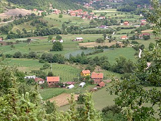
Boturovina is a village situated in Novi Pazar municipality in Serbia.
