
Westmorland is a historic county in North West England. People of the area are known as Westmerians. The area includes part of the Lake District and the southern Vale of Eden.

Kendal, once Kirkby in Kendal or Kirkby Kendal, is a market town and civil parish in the unitary authority of Westmorland and Furness, England. It lies within the River Kent's dale, from which its name is derived, just outside the boundary of the Lake District National Park.

Kirkby Lonsdale is a town and civil parish in the Westmorland and Furness district of Cumbria, England, on the River Lune. Historically in Westmorland, it lies 13 miles (21 km) south-east of Kendal on the A65. The parish recorded a population of 1,771 in the 2001 census, increasing to 1,843 at the 2011 Census.

South Lakeland was a local government district in Cumbria, England, from 1974 to 2023. Its council was based in Kendal. The district covered the southern part of the Lake District region, as well as northwestern parts of the Yorkshire Dales. At the 2011 Census, the population of the district was 103,658, an increase from 102,301 at the 2001 Census.
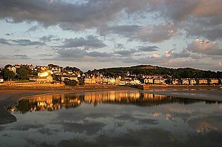
Arnside is a village and civil parish in Cumbria, historically part of Westmorland, near the border with Lancashire, England. The Lake District National Park is located a few miles north. Travelling by road, Arnside is 10 miles (16 km) to the south of Kendal, 25.3 miles (40.7 km) to the east of Ulverston, 35.2 miles (56.6 km) to the east of Barrow-in-Furness, 13 miles (21 km) to the north of Lancaster and 14.3 miles (23.0 km) to the east of Grange-over-Sands. In the 2001 census the parish had a population of 2,301, increasing at the 2011 census to 2,334.

Westmorland and Lonsdale is a constituency in the south of Cumbria, represented in the House of Commons of the UK Parliament since 2005 by Tim Farron, the former leader of the Liberal Democrats (2015–2017).

South Westmorland was a rural district in Westmorland, England from 1894 to 1974. It saw various boundary changes during its existence, particularly in 1935, when it absorbed Kirkby Lonsdale urban district, whilst parts merged with Ambleside and Grasmere Urban Districts to form Lakes Urban District at the same time. The district was abolished in 1974 under the Local Government Act 1972, with the area becoming part of the South Lakeland district of Cumbria.
Walna Scar is a hill in the English Lake District, lying just south of a pass of the same name in the Coniston Hills. Its summit at 2,035 feet (620 m) is only slightly higher than the pass.

Kendal Castle is a medieval fortification to the east of the town of Kendal, Cumbria, in northern England. The castle, which is atop a glacial drumlin, was built in the 13th century as the Caput baroniae for the Barony of Kendal. By the 15th century, the Parr family owned the castle.

Lambrigg Fell is a hill, the highest point of the area of high ground between Kendal and the M6, in south-eastern Cumbria, England.

The Castle Dairy is a medieval building located in Kendal, Cumbria. The name implies a connection to Kendal Castle and it is possibly the town's oldest continuously inhabited structure.

School Knott is a hill in the Lake District, England, to the east of Windermere town, Cumbria. It is the subject of a chapter of Wainwright's book The Outlying Fells of Lakeland. His recommended route starts at Windermere railway station and includes Grandsire at 818 feet (249 m) and a nameless summit at 806 feet (246 m). The summit is at 760 feet (230 m) and offers a view of four sections of Windermere, the lake. It has a rocky outcrop but no trig point and, as reported by Wainwright, no cairn. Schoolknott Tarn is to the south-east of the summit.

Stainton Pike is a hill in the English Lake District, near Waberthwaite, Cumbria. It is the subject of a chapter of Wainwright's book The Outlying Fells of Lakeland. It reaches 1,550 feet (470 m) and Wainwright's anticlockwise circuit also visits The Knott at 1,071 feet (326 m). The walk also passes the waterfall Rowantree Force and collection of ancient enclosures and hut circles known as Barnscar or City of Barnscar.

Scout Scar, also called Underbarrow Scar, is a hill in the English Lake District, west of Kendal, Cumbria and above the village of Underbarrow. It reaches 771 feet (235 m). Scout Scar is the subject of a chapter of Wainwright's book The Outlying Fells of Lakeland, but the summit he describes is a lower summit at 764 feet (233 m), 270m south of the highest point. Wainwright's anticlockwise recommended route also includes Cunswick Scar at 679 feet (207 m). The higher summit of Scout Scar has a topographic prominence of 109m and is thus classified as a HuMP, a hill with a prominence of at least 100m.

The Wasdale Horseshoe is a group of hills on the eastern fringe of the English Lake District, to the west of the A6, south of Shap, Cumbria. They surround the valley of Wasdale Beck, a tributary of Birk Beck and ultimately of the River Lune. The horseshoe is the subject of a chapter of Wainwright's book The Outlying Fells of Lakeland. This Wasdale should not be confused with the better known Wasdale, containing Wast Water, on the west of the Lake District.

The Wet Sleddale Horseshoe is an upland area in the English Lake District, around the Wet Sleddale Reservoir, Cumbria. It is the subject of a chapter of Wainwright's book The Outlying Fells of Lakeland. His walk starts at the reservoir dam and follows a clockwise circuit over Sleddale Pike at 1,659 feet (506 m), Great Saddle Crag at 1,850 feet (560 m) and Ulthwaite Rigg at 1,648 feet (502 m).

Knipescar Common, or Knipe Scar, is an upland area in the east of the English Lake District, above the River Lowther, near Bampton, Cumbria. It is the subject of a chapter of Wainwright's book The Outlying Fells of Lakeland. The summit is "indefinite" but reaches 1,118 feet (341 m) and there are limestone outcrops and an ancient enclosure. Wainwright commends the views which include Blencathra to the north and "a continuous skyline of the higher Pennines."

New Hutton is a village and civil parish in South Lakeland, Cumbria, England. At the 2011 Census, it had a population of 348.

Old Hutton is a village in South Lakeland, Cumbria, England. It is in the civil parish of Old Hutton and Holmescales In the 2001 census the parish had a population of 357, increasing at the 2011 census to 417.

Skelsmergh and Scalthwaiterigg is a civil parish in South Lakeland district, Cumbria, England. It was formed on 1 April 2015 by merging the parishes of Skelsmergh and Scalthwaiterigg, which had shared a parish council since 2007.
