Related Research Articles

The Trans-Canada Highway is a transcontinental federal–provincial highway system that travels through all ten provinces of Canada, from the Pacific Ocean on the west coast to the Atlantic Ocean on the east coast. The main route spans 7,476 km (4,645 mi) across the country, one of the longest routes of its type in the world. The highway system is recognizable by its distinctive white-on-green maple leaf route markers, although there are small variations in the markers in some provinces.
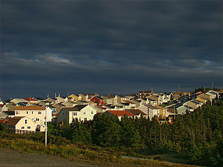
Paradise is a town on the Avalon Peninsula in the province of Newfoundland and Labrador, Canada. Paradise is the third largest settlement in the province and is part of the St. John's metropolitan area, the 20th largest metropolitan area in Canada. The town borders the City of St. John's, the City of Mount Pearl, the Town of Portugal Cove-St. Philip's, and the town of Conception Bay South. According to the 2021 census the population of Paradise was 22,957 an increase of 7.3% from its 2016 population total of 21,389.

Avalon is a federal electoral district on Newfoundland Island in Newfoundland and Labrador, Canada. It has been represented in the House of Commons of Canada since 2004.

St. John's East is a federal electoral district in Newfoundland and Labrador, Canada, that has been represented in the House of Commons of Canada since 1949.

The Trans-Labrador Highway (TLH) is the primary public road in Labrador, the mainland portion of the province of Newfoundland and Labrador, Canada. The highway's total length is 1,149 km (714 mi). The paving of the entire highway was completed in July 2022.

Humber East is a former provincial electoral district for the House of Assembly of Newfoundland and Labrador, Canada.
Route 1 is a highway in the Canada province of Newfoundland and Labrador, and is the easternmost stretch of the Trans-Canada Highway. Route 1 is the primary east–west road on the island of Newfoundland.
Goulds is a designated place in the Canadian province of Newfoundland and Labrador. It is a rural neighbourhood within the City of St. John's southeast of the city centre.
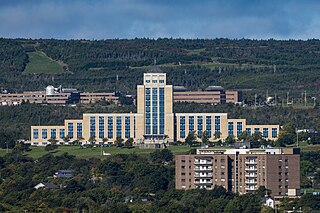
The Confederation Building serves as the home of the Newfoundland and Labrador House of Assembly. It is located on Confederation Hill overlooking Newfoundland and Labrador's capital city, St. John's. The brick- and concrete-clad building has 11 stories and is 64 metres (210 ft) tall. It was completed in 1960 at a cost of $9 million to replace the Colonial Building. A lantern is located at the top of the copper roof of the central tower and acts as a beacon when turned on at night.
The Avalon Mall is a Canadian shopping mall located in St. John's, Newfoundland and Labrador on Kenmount Road. With over 500,000 square feet (46,000 m2), two floors, and 142 stores, it is the largest shopping mall in Newfoundland and Labrador. The mall opened in 1967 and is owned by Crombie REIT.
Charlottetown is a town in Labrador with a population of 292 in the Canadian province of Newfoundland and Labrador. It was said to be founded by Benjamin Powell in 1950 and named for Charlottetown, Prince Edward Island: "I thought that maybe someday the place would be the capital of the bay, the same way Charlottetown is the capital of Prince Edward Island."

Route 2, also known as Pitts Memorial Drive and Peacekeeper's Way, is a 34.2-kilometre-long (21.3 mi) freeway on the Avalon Peninsula of Newfoundland in the Canadian province of Newfoundland and Labrador. The road provides a direct link from the Trans-Canada Highway (TCH) to downtown St. John's, Newfoundland, which was previously accessible only via city streets such as Topsail Road or Kenmount Road. Initially called the Harbour Arterial, construction began in the early 1970s and was completed in 1979. The $52-million project was funded by the federal and provincial governments. It was renamed by the city council in 1984 after local businessman James Stewart Pitt (1847-1914).
Route 50, also known as Thorburn Road and St. Thomas Line, is a 20.2-kilometre-long (12.6 mi) east-west highway on the Avalon Peninsula of Newfoundland in the Canadian province of Newfoundland and Labrador. It extends from the city of St. John's west to Paradise.
Route 40, also known as Portugal Cove Road, is a 15.3-kilometre-long (9.5 mi) north-south highway on the Avalon Peninsula of Newfoundland, extending from St. John's to the town of Portugal Cove-St. Philips in Newfoundland and Labrador, Canada.
Route 360, also known as Bay d'Espoir Highway, is a provincial highway in Newfoundland and Labrador. It runs from the Bishop's Falls area to Bay d'Espoir and Harbour Breton. The road is very isolated for at least 140 kilometres (87 mi), where there are no communities or stops to refuel. Bishop's Falls and Harbour Breton are the only two settlements of any size along the entire length of Route 360, with other towns and communities being along the other highways it intersects.

The Parkway is a major arterial road in the city of St. John's, Newfoundland and Labrador. It consists of three distinct roads that form a single through route: Columbus Drive, Prince Philip Drive, and Macdonald Drive. A four-lane limited-access road with a speed limit of 70 km/h along most of its length, the parkway begins at an intersection with Pitts Memorial Drive in the city's west end and terminates at Logy Bay Road in the east end.

Route 60, also known as Topsail Road in Mount Pearl and St. Johns, and as Conception Bay Highway for the rest of its length, is a 74.7-kilometre-long (46.4 mi) east-west highway on the Avalon Peninsula of Newfoundland. It runs between the town of Cupids and the city of St. John's.
The Stavanger Drive Shopping Area is a commercial district in the northeastern part of St. John's, Newfoundland and Labrador, Canada. It is located at the intersection of Torbay Road and Stavanger Drive, just north of Route 1. The district first opened in 1995 with stores of Costco and Zellers. As of 2015, the original area bordering Stavanger Drive has become almost entirely saturated with stores, and most further expansions are occurring to its northwest, around Hebron Way. It is accessible via two interchanges off Route 1, which are Exit 48 and Exit 49. The area is located close to St. John's International Airport.

Mount Scio is a provincial electoral district in Newfoundland and Labrador. As of 2011 there are 14,482 people living in the district.

Route 3A, also known as Team Gushue Highway, is a currently 6.6-kilometre-long (4.1 mi) north-south freeway on the Avalon Peninsula of Newfoundland in the Canadian province of Newfoundland and Labrador. It straddles the line between the provinces two largest cities, the capital city of St. John's and the city Mount Pearl. It currently envisioned to run from the Outer Ring Road to the interchange between Pitts Memorial Drive and the Goulds Bypass, but currently only runs between Route 1 and Route 60. The highway also serves as an alternative to The Parkway.
References
- ↑ "Froude says majority of residents of Kenmount Terrace in St. John's want bumps in the road | SaltWire".
- ↑ "N.L. prepares for first big increase in school enrolment in 50 years with new funding". Canadian Broadcasting Corporation . 2022-04-08. Archived from the original on 2022-10-16. Retrieved 2022-04-09.
- ↑ "Editorial in the St. John's Telegram titled "Politics beyond the overpass"" . Retrieved 2009-02-01.
- ↑ "Newspaper article about the "Beyond the Overpass Theatre Company"". Archived from the original on 2016-03-05. Retrieved 2009-02-01.