Burnaby is a city in the Lower Mainland region of British Columbia, Canada. Located in the centre of the Burrard Peninsula, it neighbours the City of Vancouver to the west, the District of North Vancouver across the confluence of the Burrard Inlet with its Indian Arm to the north, Port Moody and Coquitlam to the east, New Westminster and Surrey across the Fraser River to the southeast, and Richmond on the Lulu Island to the southwest.

Kensington, colloquially known locally as Kenzo, is a neighborhood in Philadelphia that belongs to or divides Lower Northeast and North Philadelphia. As with all neighborhoods in the city, the lack of any official designation means the boundaries of the area vary between sources over time and are disputed among locals. Kensington, as most long-term residents view it, refers generally to the area consisting of Kensington, East, or Lower Kensington, West Kensington, and Harrowgate. The adjacent Fairhill and Norris Square neighborhoods are more separate but may be included in Kensington; Fishtown and South (Olde) Kensington were historically included. The most conservative boundaries of the neighborhood, shown in the map below, are Front Street and 5th Street to the west, the Amtrak train tracks to the North, Trenton Avenue, the Trenton Avenue train tracks, and Frankford Avenue to the east, and Cecil B. Moore Avenue to the south.

West Kensington is a neighborhood in the North Philadelphia section of Philadelphia, Pennsylvania, United States. It is north of Olde Kensington. The Market Frankford El above Front Street forms the line between West Kensington and Kensington. Its bordering neighborhoods are Kensington to the east, Hartranft to the west, and Olde Kensington to the south. It is bounded by Front Street to the east, 6th Street to the west, Cecil B. Moore Avenue to the South and Lehigh Avenue to the north. It falls into the 19122 and 19133 ZIP Codes.

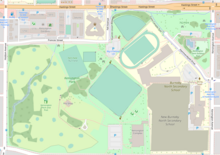
Burnaby North Secondary School is a secondary school in Burnaby, British Columbia, Canada. It encompasses two buildings at 751 Hammarskjold Drive in Burnaby. Nearly 1,800 students from grades 8 to 12 attend the school. A statue of a Viking head, the mascot of the school's sports teams, stands in front of the two buildings. Burnaby North Secondary School is nestled in Kensington Park, providing room for the school's ice rink, 18 hole pitch and putt golfing centre, outdoor swimming pool, 3 tennis courts, 4 baseball diamonds, softball diamond, an artificial turf field, 6 lane 400 metre concrete track and field tracks, and 2 outdoor natural grass fields. It is the largest school by population and school area in the school district of Burnaby School District 41.

Kingsway is a major thoroughfare that crosses through the Canadian cities of Vancouver and Burnaby, British Columbia. The road runs diagonally from northwest to southeast, emerging from Vancouver's Main Street just south of East 7th Avenue and becoming 12th Street at the Burnaby–New Westminster border.

East Vancouver is a region within the city of Vancouver, British Columbia, Canada. Geographically, East Vancouver is bordered to the north by Burrard Inlet, to the south by the Fraser River, and to the east by the city of Burnaby. East Vancouver is divided from Vancouver's "West Side" by Ontario Street.

Kensington is a neighborhood of San Diego, California. Its borders are defined by Interstate 15 to the west, Interstate 8 to the north, Fairmount Avenue to the east, and El Cajon Boulevard to the south. Its neighboring communities are Normal Heights to the west, and City Heights to the south. Kensington is part of San Diego City Council District 9. In the United States House of Representatives, Kensington is in California's 53rd congressional district, represented by Democrat Sara Jacobs. Due to redistricting, it will become part of the 51st district after the 2022 congressional election.
North Burnaby is a general name for a large neighbourhood in the City of Burnaby, British Columbia, that includes a number of smaller ones. It stretches from Boundary Road in the west to Burnaby Mountain with Simon Fraser University in the east and is bounded by Burrard Inlet to the north and the Lougheed Highway to the south. It is a desirable place to live for many local and immigrant families, which is reflected by real-estate prices that keep climbing and have doubled in the last 15 years.
Parkcrest is a hillside neighbourhood in North Burnaby, British Columbia adjacent to Kensington Park which gave it its name. It has a long rectangular shape stretched north to south and is bounded by Springer Avenue to the west and Kensington Avenue to the east. To the north its border runs along Hastings Street, its southern border lies along the Lougheed Highway and Skytrain tracks. Its elevation gradually lowers to the south and ends up in Central Valley, quite low above the level of Burnaby Lake.
Lochdale is a single-family neighbourhood in the north-eastern part of Burnaby, near Burnaby Mountain. It lies between Kensington Ave to the west and Duthie Ave to the east. Hastings Street marks its northern limits while Halifax Street closes the rectangle in the south. Additionally, a large hillside residential area between Burnaby Mountain Parkway and Greystone Drive also belongs to Lochdale. Several major thoroughfares connecting north and south run through this neighbourhood - the earlier mentioned Kensington Avenue, Duthie Avenue, and Sperling Avenue.

Georgia Street is an east–west street in the cities of Vancouver and Burnaby, British Columbia, Canada. Its section in Downtown Vancouver, designated West Georgia Street, serves as one of the primary streets for the financial and central business districts, and is the major transportation corridor connecting downtown Vancouver with the North Shore by way of the Lions Gate Bridge. The remainder of the street, known as East Georgia Street between Main Street and Boundary Road and simply Georgia Street within Burnaby, is more residential in character, and is discontinuous at several points.
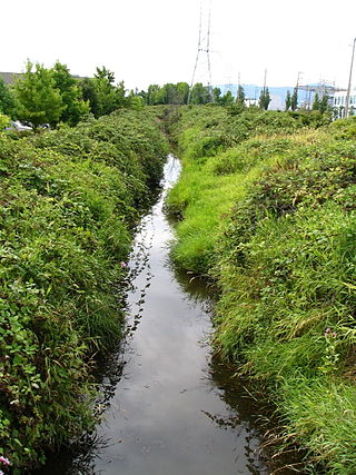
Still Creek is a long stream flowing across Central Burnaby, British Columbia and into Burnaby Lake. Still Creek's path lies mainly through the industrial area which contributes to its high level of pollution, although through dedicated work of local volunteers the creek is slowly recovering.

Montecito, for administrative and planning purposes also known as "Sperling-Broadway", is a neighbourhood in Burnaby, British Columbia, Canada.
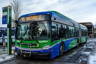
The R5 Hastings St is an express bus service with bus rapid transit elements in Metro Vancouver, Canada. Part of TransLink's RapidBus network, it travels along Hastings Street, a major east–west route, and connects Simon Fraser University to the SkyTrain system's Burrard station on the Expo Line in Downtown Vancouver. It replaced the 95 B-Line route on January 6, 2020.

Metrotown is a town centre serving the southwest quadrant of Burnaby, British Columbia, Canada. It is one of the city's four officially designated town centres, as well as one of Metro Vancouver's regional town centres. It is the central business district of the City of Burnaby.

Girard Avenue is a major commercial and residential street in Philadelphia, Pennsylvania. For most of its length it runs east–west, but at Frankford Avenue it makes a 135-degree turn north. Parts of the road are signed as U.S. Route 13 and U.S. Route 30.
Olde Richmond is a neighborhood in the River Wards section of Philadelphia, Pennsylvania, United States. It is notable for its historically large Polish immigrant, Polish American community, and Irish American community. The U.S. ZIP Code for Olde Richmond is 19125 and its post office is located at 1602 Frankford Avenue.
South Slope, sometimes referred to as Southern Burnaby, is a mainly single-family neighborhood in Burnaby in British Columbia, Canada, just southeast of Metrotown. It borders Suncrest, an all single-family home neighbourhood to the west, and goes as far east as Edmonds. Although the northern boundary of South Slope is Rumble Street, many residents north of the street consider themselves living in South Slope, including South Slope Elementary, and Burnaby South Secondary School. The neighbourhood gets its name from the steep slope it is located on. The neighbourhood is one of the oldest parts of the city, which can be seen be seen in Nelson Elementary, which is over a hundred years old, and dozens of Heritage Homes.
Marine Drive is the name for three major roadways in Greater Vancouver, British Columbia, Canada. The roads are known for running parallel to major bodies of water, with some sections being a major arterial road, while other serve local traffic. Marine Way is the name applied to a section of Marine Drive that was bypassed in the early 1980s.