Delaware is a state in the Mid-Atlantic region of the United States, bordering Maryland to its south and west; Pennsylvania to its north; and New Jersey and the Atlantic Ocean to its east. The state takes its name from the nearby Delaware River, in turn named after Thomas West, 3rd Baron De La Warr, an English nobleman and Virginia's first colonial governor.

Cecil County is a county located in the U.S. state of Maryland at the northeastern corner of the state, bordering both Pennsylvania and Delaware. As of the 2020 census, the population was 103,725. The county seat is Elkton. The county was named for Cecil Calvert, 2nd Baron Baltimore (1605–1675), the first Proprietary Governor of the Province (colony) of Maryland. It is part of the Philadelphia-Camden-Wilmington, PA-NJ-DE-MD Metropolitan Statistical Area. The county is located in Wilmington's Radio Market and Baltimore's Designated Market Area.

Kent County is a county located in the U.S. state of Maryland. As of the 2020 census, its population was 19,198, making it the least populous county in Maryland. Its county seat is Chestertown. The county was named for the county of Kent in England. The county is located on Maryland's Eastern Shore. It is one of three counties in Maryland, along with Caroline and Garrett, that is not part of a Metropolitan Statistical Area.

The Delmarva Peninsula, or simply Delmarva, is a large peninsula on the East Coast of the United States, occupied by the vast majority of the state of Delaware and parts of the Eastern Shore regions of Maryland and Virginia. The peninsula is 170 miles (274 km) long. In width, it ranges from 70 miles (113 km) near its center, to 12 miles (19 km) at the isthmus on its northern edge, to less near its southern tip of Cape Charles. It is bordered by the Chesapeake Bay on the west, Pocomoke Sound on the southwest, and the Delaware River, Delaware Bay, and the Atlantic Ocean on the east.

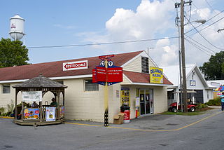
Harrington is a city in Kent County, Delaware, United States. It is part of the Dover, Delaware Metropolitan Statistical Area. Harrington hosts the annual Delaware State Fair each July. The population was 3,562 at the 2010 census.

Ellendale is a town in Sussex County, Delaware, United States. The population was 487 at the 2020 census, an increase of 27.8% since the 2010 census, and a 48.9% increase since the year 2000. It is part of the Salisbury, Maryland-Delaware Metropolitan Statistical Area. Ellendale is the "Gateway to Delaware's Resort Beaches" because it is the town located on U.S. Route 113, the resort area's westernmost border, and Delaware Route 16, the resort area's northernmost border with the eastern border being the Delaware Bay and Atlantic Ocean and the southern border being the state line with Maryland.

Betterton is a town in Kent County, Maryland, United States. The population was 345 at the 2010 census.
Claiborne is an unincorporated community in Talbot County, Maryland, United States. The village is located on the eastern shore of the Chesapeake Bay near the mouth of the Eastern Bay at 38°50′15″N76°16′40″W, and uses ZIP code 21624. The 2000 U.S. Census listed the population as 147 and the number of homes as 84, slightly down from its 1941 population of 156. Between 1890 and 1930, the village was a busy port for passenger and then automobile ferry service across the Chesapeake Bay, with numerous stores and motels/resorts, including Maple Hall. A post office was added in 1893 and the Protestant Episcopal Church of Claiborne was built in 1898. In 1912, an elementary school and Methodist Church were added. Before 1912, students attended school in nearby McDaniel. The town's first school consisted of the kitchen of the local railroad pavilion, used as a classroom. In 1913, the town became home to the Claiborne Fresh Air Association, Inc., which was formed for the purpose of providing 10 weeks of fresh air and summer vacation for children who had been exposed to tuberculosis. The role of Claiborne as a terminal for cross-Bay ferries was diminished in 1930 when the primary route shifted to Matapeake in Kent Island. It ended altogether in 1938 when the direct connection from Annapolis to Claiborne was terminated and only an auxiliary shuttle between Claiborne and Romancoke on Kent Island remained. This ended in 1952, with the opening of the Chesapeake Bay Bridge; thus ended all ferry service to Claiborne.

The Pocomoke River stretches approximately 66 miles (106 km) from southern Delaware through southeastern Maryland in the United States. At its mouth, the river is essentially an arm of Chesapeake Bay, whereas the upper river flows through a series of relatively inaccessible wetlands called the Great Cypress Swamp, largely populated by Loblolly Pine, Red Maple and Bald Cypress. The river is the easternmost river that flows into Chesapeake Bay. "Pocomoke", though traditionally interpreted as "dark water" by local residents, is now agreed by scholars of the Algonquian languages to be derived from the words for "broken ground."

The Eastern Shore of Maryland is a part of the U.S. state of Maryland that lies mostly on the east side of the Chesapeake Bay. Nine counties are normally included in the region. The Eastern Shore is part of the larger Delmarva Peninsula that Maryland shares with Delaware and Virginia.

Kent Island is the largest island in the Chesapeake Bay and a historic place in Maryland. To the east, a narrow channel known as the Kent Narrows barely separates the island from the Delmarva Peninsula, and on the other side, the island is separated from Sandy Point, an area near Annapolis, by roughly four miles (6.4 km) of water. At only four miles wide, the main waterway of the bay is at its narrowest at this point and is spanned here by the Chesapeake Bay Bridge. The Chester River runs to the north of the island and empties into the Chesapeake Bay at Kent Island's Love Point. To the south of the island lies Eastern Bay. The United States Census Bureau reports that the island has 31.62 square miles (81.90 km2) of land area.
The Baltimore and Delaware Bay Railroad, originally part of the Central Railroad of New Jersey's route from New York City to Baltimore, Maryland via central Delaware, was later part of the Pennsylvania Railroad system.

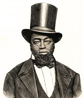
Samuel D. Burris was a member of the Underground Railroad. He had a family, who he moved to Philadelphia for safety and traveled into Maryland and Delaware to guide freedom seekers north along the Underground Railroad to Pennsylvania.

The Queen Anne’s Railroad was a railroad that ran between Love Point, Maryland, and Lewes, Delaware, with connections to Baltimore via ferry across the Chesapeake Bay. The Queen Anne's Railroad company was formed in Maryland in 1894, and received legislative authorization from Delaware in February 1895. The railroad's original western terminus was in Queenstown, Maryland, and was moved via a 13-mile (21 km) extension to Love Point in 1902, which shortened the ferry trip to Baltimore.
Frenchtown was a historic settlement on the Elk River in Cecil County, Maryland, United States.

Woodland Beach is an unincorporated community in Kent County, Delaware, United States. Woodland Beach is along the Delaware Bay, east of Smyrna at the eastern terminus of Delaware Route 6. The Woodland Beach Wildlife Area is located in Woodland Beach.
The Baltimore, Chesapeake and Atlantic railroad, nicknamed Black Cinders & Ashes, ran from Claiborne, Maryland, to Ocean City, Maryland. It operated 87 miles (140.0 km) of center-line track and 15.6 miles (25.11 km) of sidings. Chartered in 1886, the railroad started construction in 1889 and cost $2.356 million ($2022=71,055,000).

The Tilly Escape occurred in October 1856 when an enslaved woman, Tilly, was led by Harriet Tubman from slavery in Baltimore to safety in Philadelphia. Historians who have studied Tubman consider it "one of her most complicated and clever escape attempts." It was a risky trip because Tubman and Tilly would not have been able to travel directly from Baltimore to Philadelphia without proof that they were free women. In addition, local slave traders would have recognized strangers. Tubman sought to evade capture by going south, before heading north, and using different modes of transportation over water and land.
William Brinkley was a conductor on the Underground Railroad who helped more than 100 people achieve freedom by traveling from Camden, Delaware past the "notoriously dangerous" towns of Dover and Smyrna north to Blackbird and sometimes as far as Wilmington, which was also very dangerous for runaway enslaved people. Some of his key rescues include the Tilly Escape of 1856, the Dover Eight in the spring of 1857, and the rescue of 28 people, more than half of which were children, from Dorchester County, Maryland. He had a number of pathways that he would take to various destinations, aided by his brother Nathaniel and Abraham Gibbs, other conductors on the railroad.


