
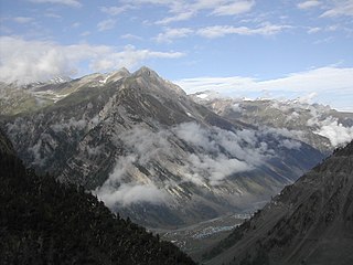
The Col du Galibier is a mountain pass in the southern region of the French Dauphiné Alps near Grenoble. It is the eighth highest paved road in the Alps, and recurrently the highest point of the Tour de France.

A mountain pass is a navigable route through a mountain range or over a ridge. Since many of the world's mountain ranges have presented formidable barriers to travel, passes have played a key role in trade, war, and both human and animal migration throughout history. At lower elevations it may be called a hill pass.
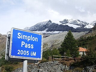
The Simplon Pass is a high mountain pass between the Pennine Alps and the Lepontine Alps in Switzerland. It connects Brig in the canton of Valais with Domodossola in Piedmont (Italy). The pass itself and the villages on each side of it, such as Gondo, are in Switzerland. The Simplon Tunnel was built beneath the vicinity of the pass in the early 20th century to carry rail traffic between the two countries.

Semmering is a mountain pass in the Eastern Northern Limestone Alps connecting Lower Austria and Styria, between which it forms a natural border.

European route E16 is the designation of a main west-east road through Northern Ireland, Scotland, Norway and Sweden, from Derry to Gävle, via Belfast, Glasgow, Edinburgh, previously by ferry to Bergen, Voss, through the Gudvanga Tunnel and the Lærdal Tunnel, Lærdal, over Filefjell to Fagernes, Hønefoss, Gardermoen and Kongsvinger. In Sweden it passes Malung, Falun and ends in Gävle.
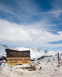
Loveland Pass is a high mountain pass in north-central Colorado, at an elevation of 11,990 feet (3,655 m) above sea level in the Rocky Mountains of the Western United States.

The Gotthard Pass or St. Gotthard Pass at 2,106 m (6,909 ft) is a mountain pass in the Alps traversing the Saint-Gotthard Massif and connecting northern and southern Switzerland. The pass lies between Airolo in the Italian-speaking canton of Ticino, and Andermatt in the German-speaking canton of Uri, and connects further Bellinzona to Lucerne, Basel, and Zurich. The Gotthard Pass lies at the hearth of the Gotthard, an important north-south axis in Europe, and it is crossed by three major traffic tunnels, each being the world's longest at the time of their construction: the Gotthard Rail Tunnel (1882), the Gotthard Road Tunnel (1980) and the Gotthard Base Tunnel (2016). With the Lötschberg to the west, the Gotthard is one of the two main north-south routes through the Swiss Alps. Since the Middle Ages, transit across the Gotthard played an important role in Swiss history, the region north of Gotthard becoming the nucleus of the Swiss Confederacy in the early 14th century.

The Salang Pass is nowadays the major mountain pass connecting northern Afghanistan with Parwan Province, with onward connections to Kabul Province, southern Afghanistan, and to the Pakistani province of Khyber Pakhtunkhwa. Located on the border of Parwan Province and Baghlan Province, it is just to the east of the Kushan Pass, and both of them were of great importance in early times as they provided the most direct connections between the Kabul region with northern Afghanistan or Tokharistan. The Salang River originates nearby and flows south.
Col de Tende is a high mountain pass in the Alps, close to the border between France and Italy, although the highest section of the pass is wholly within France.

Furka Pass, with an elevation of 2,429 metres (7,969 ft), is a high mountain pass in the Swiss Alps connecting Gletsch, Valais with Realp, Uri. The Furka Oberalp Bahn line through the Furka Tunnel bypasses the pass. The base tunnel opened in 1982 and replaced a tunnel at 2100 m.

Oberalp Pass is a high mountain pass in the Swiss Alps connecting the cantons of Graubünden and Uri between Disentis and Andermatt.
San Bernardino Pass is a high mountain pass in the Swiss Alps connecting the Hinterrhein and the Mesolcina (Misox) valleys between Thusis and Bellinzona. Located in the far eastern side of the Western Alps it is not to be confused with the Great St Bernard Pass and the Little St Bernard Pass. The top of the pass represents both the Italo-German language frontier and the watershed between the Po basin and the Rhine basin. Marscholsee is within the pass at an elevation of 2,053 m (6,736 ft).

The Pir Panjal Range is a group of mountains in the Lesser Himalayan region, running from east-southeast (ESE) to west-northwest (WNW) across the Indian state of Himachal Pradesh, the Indian administrated Union Territory of Jammu and Kashmir and the Pakistani administered territory of Pakistan occupied Kashmir, where the average elevation varies from 1,400 m (4,600 ft) to 4,100 m (13,500 ft). The Himalayas show a gradual elevation towards the Dhauladhar and Pir Panjal ranges. Pir Panjal is the largest range of the Lesser Himalayas. Near the bank of the Sutlej River, it dissociates itself from the Himalayas and forms a divide between the Beas and Ravi rivers on one side and the Chenab on the other. The renowned Galyat mountains are also located in this range. The region is connected to the Valley of Kashmir via Mughal Road and used to be the historical connection of Kashmir with India.

The Loibl Pass or Ljubelj Pass is a high mountain pass in the Karawanks chain of the Southern Limestone Alps, linking Austria with Slovenia. The Loibl Pass road is the shortest connection between the Carinthian town of Ferlach and Tržič in Upper Carniola and part of the European route E652 from Klagenfurt to Naklo.

Flexen Pass is a high mountain pass in the Austrian Alps in the Bundesland of Vorarlberg. It is at an elevation of 1,773 metres (5,817 ft).
Pyhrn Pass is a mountain pass in the Austrian Alps between the Austrian states of Upper Austria and Styria.
Sölk Pass is a high mountain pass in the Austrian Alps in the Bundesland of Styria.
Zoji La is a high mountain pass in the Himalayas in the Indian union territory of Ladakh. Located in the Dras, the pass connects the Kashmir Valley to its west with the Dras and Suru valleys to its northeast and the Indus valley further east.

The Michinoku Toll Road is a two-lane toll road in Aomori Prefecture connecting the cities Aomori and Hachinohe via Shichinohe. It serves as an alternative to Japan National Route 4, bypassing the towns Hiranai and Noheji by cutting directly through the Hakkōda Mountains and other mountains of the northern Ōu Mountain Range. The road is managed by the Aomori Prefecture Road Corporation and is numbered E4A as an extension of the Tōhoku Expressway.
