Related Research Articles
Franklin-Gordon Wild Rivers is a national park in Tasmania, 117 km west of Hobart. It is named after the two main river systems lying within the bounds of the park - the Franklin River and the Gordon River.

Southwest National Park is an Australian national park located in the south-west of Tasmania, bounded by the Franklin-Gordon Wild Rivers National Park to the north and the Hartz Mountains National Park to the east. It is a part of a chain of national parks and state reserves that make up the Tasmanian Wilderness World Heritage Area. Covering an area of 6,183 km2 (2,387 sq mi), it is Tasmania's largest national park.
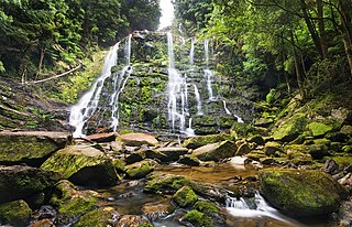
The Tasmanian temperate rain forests are a temperate broadleaf and mixed forests ecoregion in western Tasmania. The ecoregion is part of the Australasian realm, which includes Tasmania and Australia, New Zealand, New Guinea, New Caledonia, and adjacent islands.

The Great Western Tiers are a collection of mountain bluffs that form the northern edge of the Central Highlands plateau in Tasmania, Australia. The bluffs are contained within the Tasmanian Wilderness World Heritage Site.
The Wilderness Society is an Australian, community-based, not-for-profit non-governmental environmental advocacy organisation. Its vision is to "transform Australia into a society that protects, respects and connects with the natural world that sustains us."

The West Coast Range is a mountain range located in the West Coast region of Tasmania, Australia.

Linda Valley is a valley in the West Coast Range of Tasmania. It was earlier known as the Vale of Chamouni. It is located between Mount Owen and Mount Lyell.
South West Tasmania is a region in Tasmania that has evoked curiosity as to its resources over the duration of European presence on the island.

Quamby Bluff is a mountain in Northern Tasmania, Australia that is an outlying part of the Great Western Tiers mountain range.
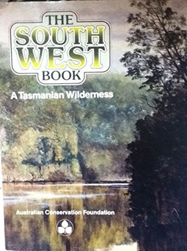
The South West Book - A Tasmanian Wilderness is a book published by the Australian Conservation Foundation in 1978 during concern following the damming of Lake Pedder in Tasmania.

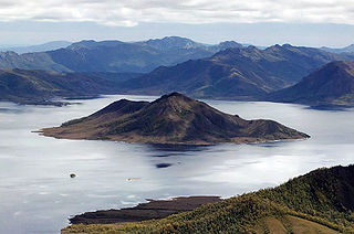
Prime Seal Island is a long island, with a high central ridge and an area of 1220 ha, in south-eastern Australia. It is part of Tasmania’s Prime Seal Island Group, lying in eastern Bass Strait west of Flinders in the Furneaux Group. Geologically, it is limestone overlying granite and has notable karst features, including caves. It is leased for farming and is extensively grazed by sheep and cattle as well as the native Tasmanian pademelons.

Marjorie Mary Sweeting, was a British geomorphologist specializing in karst phenomena. Sweeting had gained extensive knowledge on various topographies and landscapes, by travelling around the world to places such as Greece, Australia, Czechoslovakia, United States, Canada, South Africa, Belize, and most notably China. She published Karst Landforms, and Karst in China: its Geomorphology and Environment after many years of work there starting in 1977. The latter is the first comprehensive Western account of China's karst, one of the first western published works on the karst found within China, even in a male dominated field.
Gunns Plains is a small town located 20 km south of Ulverstone on the north-west coast of Tasmania, Australia.
Don Ranson is an Australian archaeologist who played an important role in the discovery and recognition of the antiquity of Aboriginal archaeology in Tasmania. This discovery has been documented in many subsequent histories of Tasmanian Archaeology, including that dedicated to the expedition itself, as well as video documentaries of the find.
Kutikina Cave is a rock shelter located on the Franklin River in the South West Wilderness, a World Heritage Area in the Australian state of Tasmania.
Tasmania's offshore islands: seabirds and other natural features is a book published by the Tasmanian Museum and Art Gallery in 2001. The book is considered an essential measure of the state of Tasmania's islands, birds inhabiting them, and the condition of the islands. The main author was Nigel Brothers, a Hobart based biologist, the other contributors were Vanessa Halley, Helen Pryor, and David Pemberton.
The Tasmanian archipelago is made up of 334 islands. This book highlights the uniqueness and importance of 280, as significant breeding refuges and wealthy natural resources. Islands are documented with descriptions of topography, wildlife, vegetation and full-colour photographs."
Helen Gee was an Australian author, editor, conservationist and environmental activist.
South West Tasmania Action Committee was a group started after the flooding of the lake in South West Tasmania known as Lake Pedder to create the Gordon Dam catchment.
The Nelson River, is located in the UNESCO World Heritage–listed Tasmanian Wilderness, in the West Coast region of Tasmania, Australia. It is a tributary into Lake Burbury, previously directly into the upper region of King River
References
- ↑ Kiernan, Kevin (June 2018), Eroding the edges of nature : Mount Field and the Florentine Valley : Tasmania's first national park and a century of lessons, Fullers Publishing (published 2018), ISBN 978-0-648-21802-9
- ↑ Kiernan, Kevin (1980), Pleistocene glaciation of the central West Coast Range, Tasmania , retrieved 18 November 2018
- ↑ Kiernan, Kevin (1985), Late Cainozoic glaciation and mountain geomorphology in the central highlands of Tasmania , retrieved 28 March 2023
- ↑ Kiernan, Kevin; Jones, Rhys, 1941-2001; Ranson, Don (1982), Glacial age man in south-west Tasmania : new evidence from Fraser Cave, Franklin River, Hobart, retrieved 30 June 2023
{{citation}}: CS1 maint: multiple names: authors list (link) - ↑ McKinnon, John, photographer; Australian Information Service (1981), Kevin Kiernan cleaning stone tools recovered during an archaeological survey in the southwest wilderness of Tasmania, Hobart, Tasmania, 27 February 1981 , retrieved 28 March 2023
{{citation}}: CS1 maint: multiple names: authors list (link) - ↑ Kiernan, Kevin; Hamilton-Smith, Elery, 1929-2015, (interviewer.) (1994), Kevin Kiernan interviewed by Elery Hamilton-Smith in Caves of Australia oral history project , retrieved 28 March 2023
{{citation}}:|author2=has generic name (help)CS1 maint: multiple names: authors list (link) - ↑ Jones, Rhys, 1941-2001 (1981), Don Ranson, Kevin Kiernan, Rhys Jones , retrieved 28 March 2023
{{citation}}: CS1 maint: multiple names: authors list (link) - ↑ Kiernan, Kevin; Tasmanian Forest Research Council (1995), An atlas of Tasmanian karst, Tasmanian Forest Research Council, ISBN 978-0-7246-3550-4
- ↑ Kiernan, Kevin (1984), Land use in karst areas : forestry operations and the Mole Creek Caves : a report to the Forestry Commission and National Parks and Wildlife Service Tasmania, Forestry Commission, retrieved 28 March 2023
- ↑ Hamilton-Smith, Elery; Kiernan, Kevin; Spate, Andy; Western Australia. Department of Environmental Protection; Hamilton-Smith, Elery; Western Australia (1998), Karst management considerations for the Cape Range Karst province Western Australia : a report prepared for the Western Australia Department of Environmental Protection, The Dept, ISBN 978-0-7309-8064-3
- ↑ "Profile: Kevin Kiernan". ResearchGate .
- ↑ Kiernan, Kevin (1996), Conserving geodiversity and geoheritage : the conservation of glacial landforms, [K. Kiernan], ISBN 978-0-7246-3559-7
- ↑ The group was established in 1976 from the members of the South West Tasmania Action Committee see - The Wilderness Society (tasmania Inc) NG2155 [Records], LINC Tasmania, 1976, retrieved 17 November 2018
| International | |
|---|---|
| National | |