The Yusufzai or Yousafzai, also referred to as the Esapzai, or Yusufzai Afghans historically, are one of the largest tribes of ethnic Pashtuns. They are natively based in the northern part of Khyber Pakhtunkhwa, to which they migrated to from Kabul during the 16th century, but they are also present in smaller numbers in parts of Afghanistan, including Kunar, Kabul, Kandahar and Farah. Outside of these countries, they can be found in Ghoriwala District Bannu, Balochistan Sibi (Akazai), Chagai (Hassanzai) and Rohilkandh.

Swat District, also known as the Swat Valley, is a district in the Malakand Division of Khyber Pakhtunkhwa, Pakistan. With a population of 2,309,570 per the 2017 national census, Swat is the 15th-largest district of Khyber Pakhtunkhwa with many popular tourist attractions.
Chakdara (چکدرہ) is a city in the Lower Dir District of Khyber Pakhtunkhwa, Pakistan. It's the second largest city in Dir Lower after Timergara. It serves as a gateway of Malakand Division. It's located in the center of Malakand Division at the entrance of the Lower Dir District, also near the entrance of the Swat District. The Swat Expressway also touches this area Chakdara interchange. Chakdara is about 130 km far from Peshawar, 40km from Mingora and 38 km from Timergara.

Dir is a region in northwestern Pakistan in the Khyber Pakhtunkhwa, in the foothills of the Himalayas. Before the independence of Pakistan, Dir was a princely state, and it remained so until 1969 when it was abolished by a presidential declaration, and the Dir District was created the following year. The area covers 5,280 square kilometres. In 1996 Dir district was officially divided into Lower Dir District and Upper Dir District.
Timergara is a city and the district headquarters of the Lower Dir District and newly established Central Dir District in Khyber Pakhtunkhwa Pakistan. Timergara city is located on the east bank of the Panjkora River. It lies at an altitude of 823 metres (2,700 ft). The town is the site of excavated graves of Indo-Aryans, dating from 1500 to 600 BC. On the west side of the Panjkora River is the excavated site of Balambat. The site has been occupied continuously since the time of the Indo-Aryans in 1500 BC. Discoveries included houses dating from 500 BC and fire altars, showing that the people followed early form Aryan religion which revolved around fire worshipping. The areas early political history is defined by the control of the Bactrians, Scythians and Hepthalites, and artifacts and ruins from these periods are found throughout the region. At the 1998 Census, the town had a population of 43,774. Most of the main city lies on the bank of the river Panjkora, which separates Balambat from the main city.
Lower Dir District is a district in the Khyber Pakhtunkhwa province of Pakistan. Timergara city is the district's headquarter. This district was formed in 1996, when Dir District was divided into Upper Dir and Lower Dir districts. Recently, On 22 January 2023, both Lower Dir and Upper Dir districts further bifurcated to create a new Central Dir District.

Upper Dir District is a district located in the Malakand Division of Khyber Pakhtunkhwa province of Pakistan. The city of Dir is its district headquarter. Geographically, it is located in the northern part of Pakistan. It borders with the Chitral district on the north, Afghanistan on the northwest, the Swat district on the east, and the Lower Dir district on the south. It shares 40 to 50 kilometers border with Afghanistan.
Shawa is a village in the Lower Dir District of the Khyber-Pakhtunkhwa province of Pakistan.
Malakand District is a district in the Malakand Division of the Khyber Pakhtunkhwa province of Pakistan.
Dherai village is an administrative unit;known as Union Council of Tehsil Kabal,District Swat, Province Khyber Pakhtunkhwa.

Badwan is a Union Council situated on the bank of the River Swat at an altitude of 2,192 feet. It is a part of the Adenzai Tehsil of the Lower Dir District, Khyber-Pakhtunkhwa. It contains many small villages including Badwan Upper, Badwan Lower, Badwan Khambo, Shamlai, Baghkandi, Ramyal, Othar, Safrona, Gadar, Barorri, Leko, Ghwando, Torogato, Swato Banda, Ghazo etc. Its population is approximately 25,000.

Khyber Medical University, is a public research university located in Peshawar, Khyber Pakhtunkhwa, Pakistan.
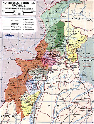
The Malakand Agency was one of the agencies in the North West Frontier Province of British India and later of Pakistan until 2010. It included the princely states of Chitral, Dir and Swat, and an area around the Malakand Pass known as the Malakand Protected Area. The largest city in the area was Mingora, while the three state capitals were Chitral, Dir, and Saidu Sharif. In 1970, following the abolition of the princely states, the agency became the Malakand Division, which was divided into districts, one of which was the Malakand Protected Area, known as Malakand District. In 2000 the Malakand Division was abolished. Despite the constitutional changes since 1970, the expression Malakand Agency is still used, sometimes of the entire area of the former Agency, but more often of Malakand District.

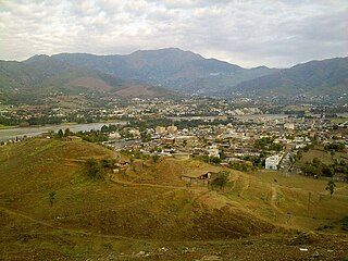
Batkhela is a city, tehsil and the district headquarter of the Malakand District within the Khyber Pakhtunkhwa province of Pakistan. According to the 2017 Census of Pakistan, the population of Batkhela was recorded at 68,200. Batkhela is considered as one of the most popular business cities in the Khyber Pakhtunkhwa province. A water canal that pours into a small dam in the Jabban area near Batkhela is the main source of electricity production here.
Kityari is a small village located in tehsil Adenzai within the District Dir Lower of the Khyber-Pakhtunkhwa province of Pakistan. The village is surrounded by Landaishah to the west, Serai to the east, Shaban to the northeast, Khanpur to the southwest and Tazagram to the south. The main road from Chakdara to Asbanr also passes through this village. The village is 12 km away from Chakdara city, which is located near Churchill Piquet on the banks of the Swat River. The population of Kityari is about 5000 and consists of primarily Pashtun people speaking the Pashto language.
Ouch is a town in the Lower Dir District of the Khyber Pakhtunkhwa province of Pakistan. The town has seen extensive expansion and enjoys good communication as it is located on the main N45 Dir Road, about 10 kilometres (6.2 mi) north of Chakdara. The region is about 138 km (86 mi) away from Peshawar and 48 km (30 mi) away from Saidu Sharif and is mainly known for its shoemakers and goldsmiths.
Middle Batkhela is one of three administrative units that forms the union council of Batkhela Tehsil. The other two are the Lower Batkhela and Upper Batkhela in the Khyber Pakhtunkhwa province of Pakistan.
Lower Batkhela is one of three administrative unit, known as Union council, of Batkhela Tehsil other being the Middle Batkhela and Upper Batkhela in the Khyber Pakhtunkhwa province of Pakistan.

Manglawar is an administrative unit, known as Union council of Tehsil Babuzai, of Swat District in the Khyber Pakhtunkhwa province of Pakistan and former capital of Kingdom of Swat. It is located at 34°48'30.7"N 72°25'50.0"E with an average altitude of 987 meters.