Khamhria

Last updated
Than-Khamhria
city
India Chhattisgarh location map.svg
Red pog.svg
Than-Khamhria
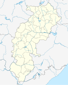
Location in Chhattisgarh, India
India location map.svg
Red pog.svg
Than-Khamhria
Than-Khamhria (India)
Coordinates: 20°59′N82°16′E / 20.98°N 82.27°E / 20.98; 82.27 Coordinates: 20°59′N82°16′E / 20.98°N 82.27°E / 20.98; 82.27
CountryFlag of India.svg  India
State Chhattisgarh
District Bemetara
Elevation 332 m (1,089 ft)
Population (2001)
  Total 6,798
Languages
  Official Hindi, Chhattisgarhi
Time zone IST (UTC+5:30)
Vehicle registration CG

Khamhria is a town and a nagar panchayat in Bemetara district in the Indian state of Chhattisgarh.

A Nagar Panchayat or Notified Area Council (NAC) or City Council in India is a settlement in transition from rural to urban.

Bemetara district District of Chhattisgarh in Chhattisgarh, India

Bemetara district is a new district in the state of Chhattisgarh, India.

India Country in South Asia

India, also known as the Republic of India, is a country in South Asia. It is the seventh largest country by area and with more than 1.3 billion people, it is the second most populous country as well as the most populous democracy in the world. Bounded by the Indian Ocean on the south, the Arabian Sea on the southwest, and the Bay of Bengal on the southeast, it shares land borders with Pakistan to the west; China, Nepal, and Bhutan to the northeast; and Bangladesh and Myanmar to the east. In the Indian Ocean, India is in the vicinity of Sri Lanka and the Maldives, while its Andaman and Nicobar Islands share a maritime border with Thailand and Indonesia.

Contents

Geography

Than-Khamhria is located at 20°59′N82°16′E / 20.98°N 82.27°E / 20.98; 82.27 . It has an average elevation of 332 m (1,089 ft).

Demographics

As of 2001 India census, [1] Than-Khamhria had a population of 6798. Males constitute 51% of the population and females 49%. Than-Khamhria has an average literacy rate of 63%, higher than the national average of 59.5%: male literacy is 72%, and female literacy is 53%. In Than-Khamhria, 14% of the population is under 6 years of age.

Census Acquiring and recording information about the members of a given population

A census is the procedure of systematically acquiring and recording information about the members of a given population. The term is used mostly in connection with national population and housing censuses; other common censuses include agriculture, business, and traffic censuses. The United Nations defines the essential features of population and housing censuses as "individual enumeration, universality within a defined territory, simultaneity and defined periodicity", and recommends that population censuses be taken at least every 10 years. United Nations recommendations also cover census topics to be collected, official definitions, classifications and other useful information to co-ordinate international practice.

Related Research Articles

Darlawn Place in Mizoram, India

Darlawn is a census town in Aizawl district in the state of Mizoram, India.

Daulatpur, Punjab city in HP, India

Daulatpur chowk is a census town in Hoshiarpur district in the state of Punjab, India.

Davorlim city in Goa, India

Davorlim is a census town in South Goa district in the state of Goa, India.

Deori, Bilaspur district city in Chhattisgarh, India

See Deori (disambiguation) for disambiguation

Durllabhganj Census Town in West Bengal, India

Durllabhganj is a census town in Garhbeta III CD Block of Medinipur Sadar subdivision in Paschim Medinipur district in the state of West Bengal, India.

Ghorawal city in Uttar Pradesh, India

Ghorawal is a town and a nagar panchayat in Sonbhadra district in the Indian state of Uttar Pradesh.

Jalalpur Town in Uttar Pradesh, India

Jalalpur is a town and a municipal board in Ambedkar Nagar district in the Indian state of Uttar Pradesh.

Katra, Gonda city in Uttar Pradesh, India

Katra is a town and a nagar panchayat in Gonda district in the Indian state of Uttar Pradesh.

Khargupur city in Uttar Pradesh, India

Khargupur is a town and a nagar panchayat in Gonda district in the Indian state of Uttar Pradesh.

Kharod city in Chhattisgarh, India

Kharod is a town and a nagar panchayat in Janjgir-Champa district in the Indian state of Chhattisgarh.

Kishangarh Bas city in Rajasthan, India

Kishangarh Bas is a census town in Alwar district in the Indian state of Rajasthan.

Mohammadabaad, Farrukhabad district city in Uttar Pradesh, India

Mohammadabad is a town and a nagar panchayat in Farrukhabad district in the Indian state of Uttar Pradesh.

Mundwa City in Rajasthan, India

Mundwa (मूंडवा) also known as Marwar Mundwa, is a city and a municipality in Nagaur district in the Indian state of Rajasthan. Mundwa is a Tehsil in Nagaur District of Rajasthan State, India. Mundwa Tehsil Headquarters is Mundwa City. It belongs to Ajmer Division. It is located 20 km towards South from District headquarters Nagaur. 231 km from State capital Jaipur towards East. Marwari is the Local Language here. Also People Speaks Hindi, English, Urdu and Rajasthani. Mundwa was also a constituency of Rajasthan Assembly before it was changed to Khinwasar because of political reasons. Now Mundwa is made a Tehsil. It is also allotted a Dhan Mandi. It is a pilgrimage centre for the shrine of the Sufi Haz Jana Sahid and is also famous for the lot of temples.

Panagar Town in Madhya Pradesh, India

Panagar is a town with municipality in Jabalpur district in the Indian state of Madhya Pradesh.

Tekanpur, India city in Madhya Pradesh, India

Tekanpur is a census town in Gwalior district in the Indian state of Madhya Pradesh. The town is also home to the Border Security Force Academy where the Assistant Commandants and the Sub-Inspectors of the BSF train.

Usehat city in Uttar Pradesh, India

Usehat is a town and a nagar panchayat in Badaun district in the Indian state of Uttar Pradesh. It is a town in usawan block.

Vadakkuvalliyur is a panchayat town in Tirunelveli district in the Indian state of Tamil Nadu.

Daulatpur, Himachal Pradesh town in Himachal Pradesh, India

Daulatpur is a nagar panchayat in Tehsil Ghanari of Una district in the state of Himachal Pradesh, India. It is situated in the Punjab region of Indian Subcontinent

Ratangarh, Neemuch city in Madhya Pradesh, India

Ratangarh is a town and a nagar parishad in Neemuch district in the Indian state of Madhya Pradesh.

References

  1. "Census of India 2001: Data from the 2001 Census, including cities, villages and towns (Provisional)". Census Commission of India. Archived from the original on 2004-06-16. Retrieved 2008-11-01.