Related Research Articles
Churu is a city in the desert region of Rajasthan state of India. It is known as the gateway to the Thar Desert of Rajasthan. It is the administrative headquarter of Churu District. It lies in the Thar Desert on the National Highway 52 connecting Sangrur to Ankola and is a junction station on the railway line to Bikaner. It is near the shifting sand dunes of the Thar Desert and has grand havelis with marvelous fresco paintings, namely Kanhaiya Lal Bagla Ki Haweli and Surana Haweli, with hundreds of small windows. It also has some fine Chhatris. Near the town is a religious seat of the Nath sect of Sadhus where there are life-size marble statues of their deities and a place for prayers. At the center of the town is a fort built about 500 years ago.
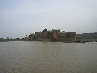
Jhalrapatan is a town in Jhalawar district in the south of Rajasthan state in India. Its population is approximately 37,506. The former Chief Minister of Rajasthan, Vasundhara Raje, has been three times elected as MLA from this town. The name may be derived from "city of [temple] bells", or from the Jhala tribe of regent Jalim Singh. The first municipality was established in Jhalrapatan. India's last fort was built here.
Jhalawar is a city in the Indian state of Rajasthan. It is located in the southeastern part of the state. It was the capital of the former princely state of Jhalawar, and is the administrative headquarters of Jhalawar District. Jhalawar was once known as BRIJNAGAR.
Mahendragarh district is one of the 22 districts of Haryana state in northern India. The district occupies an area of 1,899 km² and has a population of 922,088 (2021census). District have 3 Sub-divisions : Narnaul, Mahendragarh and Kanina
Jhalawar district is one of the 33 districts of Rajasthan state in western India. The district is bounded on the northwest by Kota district, on the northeast by Baran district, on the east by Guna district of Madhya Pradesh state, on the south by Rajgarh and Shajapur districts of Madhya Pradesh state and on the west by Ratlam, Mandsaur and Neemuch districts of Madhya Pradesh state. The district occupies an area of 6928 km². The district is part of Kota division. The historical city of Jhalawar is the administrative headquarters of the district. To know more about Jhalawar City
Aklera is a town and a municipality in Jhalawar district in the state of Rajasthan, India. It has a rock-strewn, scrub-covered terrain, occasionally bright with fields of poppies and citrus-green groves of oranges. Lying in the south-eastern region of Rajasthan at the edge of the Malwa plateau, Aklera area has rocky but water-laden verdant landscape, unlike much of Rajasthan.
Budhana is a town, block, tehsil, Nagar Panchayat, and one of the constituencies of the Uttar Pradesh Legislative Assembly in Muzaffarnagar district in the state of Uttar Pradesh, India.
Ramganj Mandi is a city and a municipality in Kota district in the Indian state of Rajasthan. It is known as stone city, coriander city. It has the largest grain market of coriander with around 6500 tons of coriander seeds arriving on a single day during season. Spices Giant MDH buys its coriander seeds from Ramganj Mandi. A new spice park is being constructed on Nimana road, the link road between SH 9B and NH 12. Annually billions of square feet of limestone is exported throughout the country, mainly in Punjab, Haryana, Chandigarh, Gujarat, Maharashtra and Madhya Pradesh. Around 1000 stone processing units are set up in the industrial area. More than 80 mines are present in the area.
Rani is a town and municipality and subdistrict of Pali district in the Indian state of Rajasthan. It lies on the banks of Sukri River, a tributary of the Luni River. It is an important railway station on Ahmedabad-Delhi railway line.

Rawla Mandi is a tehsil Rawla Mandi tehsil of Sri Ganganagar district of Rajasthan, India. It is located on Gharsana-Khajuwala road, 24 km away from Gharsana and 180 km from the district headquarters Sri Ganganagar. The state capital Jaipur is 480 km away, and national capital New Delhi is 600 km away. It is 55 km from Anupgarh, 33 km from Khajuwala and 122 km from Bikaner. It is 30 km far from Indo-Pak(India-Pakistan) border. Rawla mandi known as 8PSD (B) gram panchayt. Rawla Gaon Also located in West of rawla mandi
Sunel is a city in Jhalawar district, Rajasthan, India, with a population of about 25000. It was formerly known as Ahilya Nagri. The Ahu River is 3 kilometres (2 mi) from Sunel.
Peepal Khoont mainly known as Pipalkhunt is a Tehsil headquarter and Panchayat Samiti of the Pratapgarh district of Rajasthan state. It is a sub-division among the 5 sub-divisions of the Pratapgarh district. The main market is called Sadar Bajar. It is situated on National Highway 113. Pipalkhunt is a town located on the Banswara - Jaipur Expressway surrounded by the hills, plants and trees. The town is situated on the bank of the Mahi River.
Khanpur Ahir is a village in Mundawar Mandal in Alwar District in the Indian state of Rajasthan. Khanpur Ahir is 40 km far from its District Headquarter Alwar. It is 140 km far from its State Capital Jaipur.
Bar Bar is a village in Hakimabad Rural District, in the Central District of Zarandieh County, Markazi Province, Iran. At the 2006 census, its population was 523, in 134 families. According to Census 2011 information the location code or village code of Bar Bar village is 104268. Bar Bar village is located in Jhalrapatan Tehsil of Jhalawar district in Rajasthan, India. It is situated 24km away from sub-district headquarter Jhalrapatan and 32km away from district headquarter Jhalawar. As per 2009 stats, Barbar is the gram panchayat of Bar Bar village.
Gehoon Kheri is a village located in the taluk of Bakani, district of Jhalawar, in the State of Rajasthan in India. The village is near Aklera town which is situated at an altitude of 469 meters. The village's history spans more than 700 years. The village's population is more than 5,000 as per the 2011 census.
Nasopur is a village in Kotkasim, Tehsil Alwar district, in the Indian state of Rajasthan. It is located around 75 km south of Delhi, 75 km north of Alwar, and about 200 km north of Jaipur, the capital of Rajasthan. Nasopur is part of Greater Bhiwadi and National Capital Region (NCR).

Singhana is a town having sub-Tehsil and panchayat smiti, located in Jhunjhunu district of Rajasthan, in India.

Atru is a town in the Baran district in Rajasthan, India. It is located in the southeast of northern Indian state of Rajasthan. It is tehsil of Baran. It is located around 30 kilometres south of the Baran district. Atru tehsil is the biggest tehsil of the Baran district, and has 141 villages under its administration. There are many facilities like a railway station, a hospital, schools, markets, well equipped rods for traffic. The most famous festival is Dhanush lila on the occasion there is a fair is organized for 3 days.
Gandala is a Gram Panchayat Village and Up-Tehsil in Behror tahsil/Sub-district, Alwar, Rajasthan, India. It is the second largest Village by population in Behror Tehsil after Bardod Village according to 2011 Census of India and situated on Behror-Kund Road. It is 7 km from Sub-district headquarters and 70 km from District headquarters. It is 140 km from state capital and 120 km from national capital .The village is well known for its ancient temple which is named after Sati Nihali Mata. The main occupation of people in this rural area is Agriculture.The Majority population in village mainly Yadavs.
Asnawar is a small town in Jhalawar district, Rajasthan, India, with a population of about 15,000. It was formerly known as Aasnaver. The Kalisindh River is 8 kilometres (5 mi) from Asnawar. Also famous temples like rata devi, kham kheda, modi ki jahar.
References
- ↑ "Khanpur City Population Census 2011 - Rajasthan". Census2011.co.in. Retrieved 20 June 2017.