Tehran Imam Khomeini International Airport, is the primary international airport of Tehran, the capital city of Iran, located 30 kilometers southwest of Tehran, near the localities of Robat Karim and Eslamshahr and spread over an area of 13,500 hectares of land. Along with Mehrabad International Airport, Imam Khomeini Airport is one of the two international airports serving Tehran. All International flights in Tehran are currently served by this airport and all domestic flights are served by Mehrabad Airport. the airport has served about 9 million international passengers. It ranked 3rd in terms of total passenger traffic in Iran after Tehran Mehrabad Airport and Mashhad Airport. The airport is operated by the Iran Airports Company and is one of the home base of Iran's international airlines, Iran Air, Mahan Air and some other.

Bandar-e Emam Khomeyni is a city and capital of Bandar-e Emam Khomeyni District of Mahshahr County, Khuzestan Province, Iran. At the 2006 census, its population was 67,078, in 14,681 families.
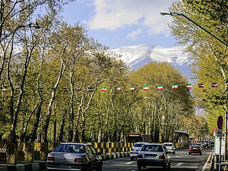
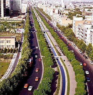
Valiasr Street or Pahlavi Street is a tree-lined street in Tehran, Iran, dividing the metropolis into western and eastern parts built in 1922 to 1927, considering the end of asphalt plan it ended in 1933. It is considered one of Tehran's main thoroughfares and commercial centres. It is also the longest street in the Middle East, and was reported as one of the longest in the world by former BBC journalist Rageh Omaar during the television documentary Welcome to Tehran.

The Tehran Metro is a rapid transit system serving Tehran, the capital of Iran. The system consists of 6 operational metro lines, with construction under way on three lines including west extension of line 4, line 6 and north and east extension line 7.

Park e Shahr, literally the City Park, with its 26 hectares, is a major park located in the region 12th, central Tehran, Iran. It is surrounded by Fayaz Bakhsh Street from the north, Hafez Street from the west, Behesht Street from the south and Khayyam Street from the east.
Jamaran is a neighbourhood located north of the city of Tehran in Iran.
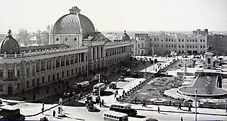
ToopKhāneh, also spelt as Tūpkhāneh, is a major town square and a neighborhood in the south of the central district of the city of Tehran, Iran. It was built in 1867 by an order of Amir Kabir and Commissioned in 1867. After the Iranian Revolution, it was renamed Imam Khomeini Square. Cheragh Bargh street ends-up to this square, and Naserie street, Bob Homayoun street, Sepah street, Ferdowsi street and Lalezar street find ways to other directions.

Hasan Abad Metro Station is a station in Tehran Metro Line 2. It is located in the junction of Imam Khomeini Street and Hafez Street in Si-o-Yek Shahrivar Square. It is between Imam Khomeini Metro Station and Imam Ali University Metro Station.
Daneshgah-e Emam Ali Metro Station, which is translated into Imam Ali University Metro Station is a station in Tehran Metro Line 2. It is located in Imam Khomeini Street in front of the old Majles building near Imam Ali University. It is between Imam Khomeini Metro Station and Hor Square Metro Station. The station is named after Imam Ali University for Army Officers, which is located near the station on Imam Khomeini Street. The Assembly of Experts' building is also located next to this station.

Meydan-e Horr Metro Station is a station in Tehran Metro Line 2. It is located in Hor Square the junction of Imam Khomeini Street and Kargar Street. It is between Imam Ali University Metro Station and Navvab Metro Station.

Enqelab Street is a major trunk route in Tehran, Iran connecting Enqelab square to Imam Hossein Square.

Tehran Metro Line 1, coloured red on system maps runs north-south and is 36.6 kilometers (22.7 mi) of which 14.9 km (9.3 mi) is underground and the rest at grade. The number of stations along this line is 29 of which 22 stations are underground and 7 above. As of 2005, the line's total capacity is 650,000 passengers per day and trains make a scheduled stop of 20 seconds per station. The trains are made up of seven wagons, giving a nominal capacity of 1,300 seated and standing passengers. The maximum speed of the trains is 80 km/h (50 mph) per hour in practice tempered to an average 45 km/h (28 mph) due to station stops.

Tehran Metro Line 2, which opened between Sadeghieh and Imam Khomeini in February 2000, is 20.4 kilometers (12.7 mi) long, with 19 km (12 mi) as a subway and 1.4 kilometers (0.87 mi) elevated. At this time, there were 19 stations along the line, of which Imam Khomeini Station was shared by Line 1. Line 2 is coloured blue on system maps and runs mostly east–west through the city.
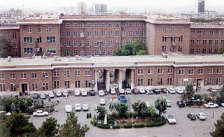
Imam Khomeini Hospital or also Imam Khomeini Hospital Center is a teaching hospital complex and biomedical research facility of Tehran University of Medical Sciences, located in Tehran, Iran.
Keshavarz Boulevard (Blvd.) or simply Bolvār is a central Boulevard in Tehran, Iran. It is a 2.2 km long, East-West boulevard which connects Valiasr Street and Valiasr Sq. to Imam Khomeini Hospital Complex and is located in District 6 of Tehran. This boulevard was named "Elizabeth Boulevard" after Queen Elizabeth II visit to Iran during the former regime of Iran, Pahlavi dynasty. However, after the 1979 Revolution, it was renamed Keshavarz Boulevard, as the main building of the Ministry of Agriculture of Iran was located close to this boulevard.

Sayyid Ruhollah Mūsavi Khomeini, known in the Western world as Ayatollah Khomeini, was an Iranian Shia Muslim religious leader, philosopher, revolutionary and politician. He was the founder of the Islamic Republic of Iran and the leader of the 1979 Iranian Revolution that saw the overthrow of the Pahlavi monarchy and Mohammad Reza Pahlavi, the Shah of Iran. Following the revolution, Khomeini became the country's Supreme Leader, a position created in the constitution of the Islamic Republic as the highest-ranking political and religious authority of the nation, which he held until his death. On 1 February 1979 Ayatollah Ruhollah Khomeini, returned to Iran after 14 years in political exile. Khomeini had been a prominent opponent of Mohammad Reza Shah Pahlavi, who had fled the country during the events of the Iranian Revolution. Upon his return, he was greeted by crowds of millions, and within 10 days the revolution would be successful. Khomeini's return and the 10 days following are now celebrated in Iran as the Fajr decade.

Tehran–Qom–Isfahan High Speed Rail is the first truly high-speed rail project in Iran, currently under construction. The rail line would decrease travel times between Tehran and Isfahan, passing through Qom. It also connects Isfahan and Qom to Imam Khomeini International Airport, the most important international airport of Iran, making international air travel for passengers from Qom and Isfahan much more convenient. Civil works are undertaken by Chinese consortium led by China Railway Engineering Corporation.
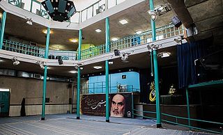
Ruhollah Khomeini's residency is the house of Ruhollah Khomeini, the founder of the Islamic Republic of Iran, in Jamaran village. On 23 January 1980, Ayatollah Khomeini went to Tehran from Qom to cure a heart ailment. According to doctors recommendation, the weather of Qom did not agree with him. The house of Khomeini was next to the Hussainiya in Jamaran village. The house was very small and his room was 12 square meters. The house was linked to a large mosque by a metal platform. Khomeini often walked up a flight of stairs leading from his house to the balcony of the mosque, from which he often spoke.

Shahr-e Forudgahi-e Imam Khomeini Metro Station, also referred to as Imam Khomeini Airport Metro Station, is a station on Tehran Metro Line 1, its extension. It is adjacent to Tehran Imam Khomeini International Airport. The station serves the airport and the surrounding, related facilities. It is currently the southern terminus. The line is intended to be continued towards Parand.

Keikhosro Khoroush is an Iranian painter and calligrapher. He graduated at the first rank in the College of Art, University of Tehran. He has been one of the most realistic Iranian painters and one of the great masters in Persian calligraphy since 1980. He was awarded the title of the everlasting people in 2005.