Related Research Articles

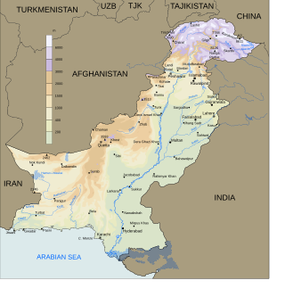
Makran, also mentioned in some sources as Mecran and Mokrān, is the southern coastal region of Balochistan. It is a semi-desert coastal strip in the Balochistan province in Pakistan and in Iran, along the coast of the Gulf of Oman. It extends westwards, from the Sonmiani Bay to the northwest of Karachi in the east, to the fringes of the region of Bashkardia/Bāšgerd in the southern part of the Sistan and Baluchestan province of modern Iran. Makrān is thus bisected by the modern political boundary between Pakistan and Iran.

Pulicat Lake is the second largest brackish water lagoon in India,, measuring 759 square kilometres (293 sq mi). Major part of the lagoon comes under the Tirupati district of Andhra Pradesh. The lagoon is one of three important wetlands that attracts northeast monsoon rain clouds during the October to December season. The lagoon comprises the following regions: Pulicat Lake, Marshy/Wetland Land Region (AP), Venadu Reserve Forest (AP), and Pernadu Reserve Forest (AP). The lagoon was cut across in the middle by the Sriharikota Link Road, which divided the water body into lagoon and marshy land. The lagoon encompasses the Pulicat Lake Bird Sanctuary. The barrier island of Sriharikota separates the lagoon from the Bay of Bengal and is home to the Satish Dhawan Space Centre.

Chilika Lake is the largest brackish water lagoon in Asia and second largest coastal lagoon in the world, spread over the Puri, Khordha and Ganjam districts of Odisha state on the east coast of India, at the mouth of the Daya River, flowing into the Bay of Bengal, covering an area of over 1,100 square kilometres (420 sq mi). Another lake in India called Vembanad Lake is the longest lake in India. Chilika Lake comes after the New Caledonian barrier reef. It has been listed as a tentative UNESCO World Heritage site. Its salinity varies by region, from nearly freshwater where rivers flow in, to oceanic salinity levels due to tidal influx.

Jiwani is a town and commercial port that is located along the Gulf of Oman in the Gwadar District of the Balochistan province in Pakistan. The town is also next to the Iran-Pakistan border. The town has a total population of 25,000 and is expected to become a major commercial centre in concert with the development of the port city of Gwadar. Gwadar is located nearly 60 kilometres (37 mi) to the east. They also are working with the port city of Chabahar in Iran's Sistan and Baluchestan Province which is about 115 kilometres (71 mi) to the west of Jiwani.
Pasni, is a city and a fishing port in Gwadar District, Balochistan, Pakistan. It is located on the Makran coast on Arabian Sea about 450 km (280 mi) from Karachi. Administratively, Pasni is the headquarters of Pasni Tehsil, the sub-division of Gwadar District. Astola Island lies 40 km (25 mi) ESE of Pasni, in the Arabian Sea. The city of Pasni is itself administratively subdivided into two Union Councils.

Ormara (Balochi and Urdu: اورماڑا, Urdu pronunciation:[oːɾmɑːɽɑː], is a town in Gwadar District in the Balochistan province of Pakistan. It is a port in the Makran coastal region. It is located 360 kilometres west of Karachi and 230 kilometres east of Gwadar on the Arabian Sea. This port is also mentioned in Periplus of the Erythraean Sea as Oraea.
Machar Colony or Machiara Colony is an unplanned settlement in Karachi, Pakistan, located near the Port of Karachi and Lyari. The settlement is spread over an area of almost 4 square kilometers, and is home to about 700,000 people. It is considered to be one of the most dilapidated slums in Karachi. Also the level of danger prevalent in Machar Colony becomes apparent when considering one of the most horrifying incidents that occurred there. In this tragic event, a mob in the Colony district brutally killed two telecom employees, falsely accusing them of being kidnappers. The victims were identified as Engineer Muhammad Ayman Javed, the son of Saeed Javed, and Muhammad Ishaq Panhwar, the son of driver Muhammad Haroon.

Astola Island also known as Jezira Haft Talar, Satadip or 'Island of the Seven Hills', is a small uninhabited Pakistani island in the Arabian Sea approximately 25 km (16 mi) south of the nearest part of the coast and 39 km (24 mi) southeast of the fishing port of Pasni. Astola is Pakistan's largest offshore island at approximately 6.7 km (4.2 mi) long with a maximum width of 2.3 km (1.4 mi) and an area of approximately 6.7 km2 (2.6 sq mi). The highest point is 246 ft (75 m) above sea level. Administratively, the island is part of the Pasni subdistrict of Gwadar District in Balochistan province. The island can be accessed by motorized boats from Pasni, with a journey time of about 5 hours to reach the island. On August 4 2020, Pakistan released a new political map that for the first time showed the Islands of Churna and Astola.
Jiwani Airport is situated 10 km away from the city centre of Jiwani in Balochistan. It is not a major airport of Pakistan. At this time, there is no scheduled service to or from the airport. Jiwani or Jwani is a town and commercial port that is located along the Gulf of Oman in the Gwadar District of the Balochistan province in Pakistan. It is located near the Pakistani border with Iran. With the Makran Coastal Highway now reaching Jiwani from Gwadar and also connecting Karachi, Jiwani is a place to be seen especially by those who are interested in observing history more closely.
The Keti Bandar Port is a port on the Arabian Sea, in the Thatta District, Sindh, Pakistan. Keti Bandar is approximately 150 highway kilometers from Karachi, with a driving time of around 3.5 to 4 hours. Two of the larger towns on the route from Karachi to Keti Bandar are Gharo and Mirpur Sakro.

Fishing in India is a major sector within the economy of India contributing 1.07% of its total GDP. The fishing sector in India supports the livelihood of over 28 million people in the country, especially within the marginalized and vulnerable communities. India is the third largest fish producing country in the world accounting for 7.96% of the global production and second largest producer of fish through aquaculture, after China. The total fish production during the FY 2020-21 is estimated at 14.73 million metric tonnes. According to the National Fisheries Development Board the Fisheries Industry generates an export earnings of Rs 334.41 billion. Centrally sponsored schemes will increase exports by Rs 1 lakh crore in FY25. 65,000 fishermen have been trained under these schemes from 2017 to 2020. Freshwater fishing consists of 55% of total fish production.

The wildlife of Pakistan comprises a diverse flora and fauna in a wide range of habitats from sea level to high elevation areas in the mountains, including 195 mammal, 668 bird species and more than 5000 species of Invertebrates. This diverse composition of the country's fauna is associated with its location in the transitional zone between two major zoogeographical regions, the Palearctic, and the Oriental. The northern regions of Pakistan, which include Khyber Pakhtunkhwa and Gilgit Baltistan include portions of two biodiversity hotspot, Mountains of Central Asia and Himalayas.

Odisha, a state in eastern India, is extremely diverse and gives the state abundance of natural beauty and wildlife. The districts in the interior are thickly covered by tropical moist deciduous and tropical dry deciduous forests. The hills, plateaus and isolated areas of the northeastern part of the state are covered by the tropical moist deciduous forests whereas the dry deciduous forests are located in the southwest region of the state. Some of the trees which grow in abundance in Odisha are bamboo, teak, rosewood, sal, piasal, sanghvan and haldi. There are 479 species of birds, 86 species of mammals, 19 species of amphibians and 110 species of reptiles present in Odisha. The state is also an important habitat for the endangered olive ridley turtles and Irrawaddy dolphins. Koraput district of southern Odisha has been identified by Food and Agriculture Organisation (FAO) of UN as Global Agricultural Heritage site which is among only other three sites in the world. Other sites are in Peru, China and Philippines.
Basol River is a river that flows southward in the Gwadar District of Balochistan Province, in southwestern Pakistan.
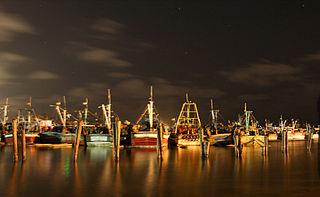
Fishery and fishing industry plays a significant part in the national economy of Pakistan. With a coastline of about 1,120 km, Pakistan has enough fishery resources that remain to be developed. Most of the population of the coastal areas of Sindh and Balochistan depends on fisheries for livelihood. It is also a major source of export earning.
Pakistan Naval Station Makran, known as PNS Makran formerly known as Coastal Naval Air Station, Pasni, is a Naval air station and a military airport located in Coastal city of Pasni of Balochistan. It is one of the two active Naval Air Arm's bases and is currently headquarters to the Pakistan Navy's Alouette III and Lynx helicopters.

Kalmat Naval Base is a proposed naval base of the Pakistan Navy at Khor Kalmat, Balochistan, Pakistan.
Royapuram fishing harbour, also known as Chennai fishing harbour or Kasimedu fishing harbour, is one of the major fishing grounds for catching fishes and crustaceans located at Kasimedu in the Royapuram area of Chennai, India. The harbour is located north of the Chennai Port and is under the administrative control of the Chennai Port Trust. The harbour is also a shipbuilding facility, chiefly building fishing boats. The nearest railway station is the Royapuram Railway Station.

The fishing industry in Denmark operates around the coastline, from western Jutland to Bornholm. While the overall contribution of the fisheries sector to the country's economy is only about 0.5 percent, Denmark is ranked fifth in the world in exports of fish and fish products. Approximately 20,000 Danish people are employed in fishing, aquaculture, and related industries.

Underwater diving encompasses a variety of economically and culturally significant forms of diving on the U.S. island territory of Guam. Scuba diving tourism is a significant component of the island's tourist activity, in particular for visitors from Japan and South Korea. Recreational diving by Guam residents has a lesser but still substantial economic impact. Marine biologists have raised concerns about the effect of diving upon the health of some of Guam's reefs. Recreational dive sites on Guam include submerged shipwrecks, such as the double wrecks of SMS Cormoran and Tokai Maru, and natural features, such as Blue Hole.