
Terich Mir is the highest mountain of the Hindu Kush range, and the highest mountain in the world outside of the Himalayas–Karakoram range, at 7,708 meters (25,289 ft) above sea level. It is located in the Chitral District of Khyber Pakhtunkhwa, Pakistan.

Chitral is a city situated on the Chitral River in northern area of Khyber Pakhtunkhwa. It serves as the capital of the Lower Chitral District, and was previously the capital of Chitral District, and before that the capital of Chitral princely state. The region was encompassed into West Pakistan between the years 1969 and 1972. It has a population of 49,780 per the 2017 census.
The Katir are a Nuristani tribe in Afghanistan and Pakistan.

Pakistani folklore encompasses the mythology, poetry, songs, dances and puppetry from Pakistan's various ethnic groups.
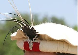
The pakol or pakul is a soft, flat, rolled-up, round-topped men's cap, usually worn in Afghanistan and Pakistan. It is typically made of wool and found in a variety of earthy colours, such as brown, black, grey, ivory, or dyed red using walnut. The pakol is believed to have originated in Chitral, or Gilgit-Baltistan in Pakistan.
Malakand District is a district in the Malakand Division of the Khyber Pakhtunkhwa province of Pakistan.
Chitral is a town in the North West Frontier Province of Pakistan.

The Kho or Chitrali people, are an Indo-Aryan ethnolinguistic group native to the Chitral District in Khyber Pakhtunkhwa, Pakistan and the Gupis-Yasin and Ghizer districts of Gilgit-Baltistan. They speak an Indo-Aryan language called Khowar.

The Kalash, or Kalasha, are an Indo-Aryan indigenous people residing in the Chitral District of the Khyber-Pakhtunkhwa province of Pakistan.

Pakistanis are the citizens and nationals of the Islamic Republic of Pakistan. According to the 2017 Pakistani census, the population of Pakistan stood at over 213 million people, making it the world's fifth-most populous country. About 97% of Pakistanis are Muslims. Since 2024, Pakistan has officially become the country with the largest Muslim population in the world, surpassing Indonesia. The majority of Pakistanis natively speak languages belonging to the Indo-Iranic family.

The Khoshey are a Kho tribe residing in the Torkhow, Mulkhow, Laspur, Chitral, Drosh, Tirich Mir, Ayon, Chitral District of Khyber-Pakhtunkhwa province of Pakistan and Badakhshan. The Khoshey speak the Khowar language.

Chitrali cuisine refers to the food and cuisine of the Chitrali people from the northern region of the Khyber Pakhtunkhwa province of Pakistan and the bordering Nuristan province in Afghanistan. Chitrali food has a regional variance in contrast to many other cuisines of Pakistan. The food of Chitral is very similar to the cuisine in neighboring Gilgit-Baltistan.
Shahzada Mohiuddin was a Pakistani politician, a Federal and Provincial Minister, and Member of the National Assembly of Pakistan. He served as Minister of State for Tourism and Chairman National Assembly Standing Committee on Kashmir Affairs and Northern Areas. He was the grandson of Sir Shuja ul-Mulk. His eldest son Shahzada Iftikhar Uddin was elected as the MNA from Chitral in 2013.

Golaghmuli Valley or Koh-i-Ghizer or Valley of Martyrs or Shandur Valley is a high mountainous valley located in the Gupis–Yasin District of Gilgit-Baltistan, Pakistan.

Eastern Kata-vari also locally known as Shekhani is a variety of the Kata-vari language spoken in Chitral district of Khyber-Pakhtunkhwa province of Pakistan. The Kamviri language is also known as Shekhani. The Khowar name for the dialect is Sheikhwar which means "Language of the Sheikhs or converts." Some linguists consider Shekhani or Eastern Kata-vari a different language due to the isolation from other Nuristani languages other than Kamviri. Kamviri Shekhani is different than Eastern Kata-vari which is also called Shekhani.

Lower Chitral District is a district in Malakand Division of Khyber Pakhtunkhwa province in Pakistan.

Upper Chitral District (Khowar: توری ݯھیترارو ضلع)(Pashto: پورتنۍ چترال ولسوالۍ) is a district in the province of Khyber Pakhtunkhwa, Pakistan. Chitral River flows across the length of the district. Upper Chitral District along with Lower Chitral District were part of the erstwhile Chitral District which was the largest district in the Khyber-Pakhtunkhwa province, covering an area of 14,850 km2. Previously, it served as the Chitral princely state that encompassed the region until its incorporation into the Khyber Pakhtunkhwa province of Pakistan in 14 August 1947. The erstwhile Chitral District was bifurcated into Upper Chitral District and Lower Chitral District in November, 2018.

Madaklashti is a dialect of Persian, spoken in the village of Madaklasht which is located in the Shishikoh valley in Lower Chitral District of Khyber Pakhtunkhwa, Pakistan. It is closely related to the Dari-Tajik dialects spoken in the Badakhshan region of Afghanistan and Tajikistan. It is completely isolated from other languages in the area and rarely draws any loanwords from Khowar. Madaklashti was also influenced by Pamiri languages especially Rushani.
Madaklasht is a valley located in Lower Chitral district, Khyber Pakhtunkhwa, Pakistan. The valley is predominantly inhabited by the Tajik people who speak Madaklashti, a dialect of Persian.
