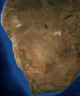
The Kalahari Desert is a large semi-arid sandy savanna in Southern Africa extending for 900,000 square kilometres (350,000 sq mi), covering much of Botswana, and parts of Namibia and South Africa.

At 824,292 km2 (318,261 sq mi), Namibia is the world's thirty-fourth largest country. After Mongolia, Namibia is the second least densely populated country in the world.

The Okavango River is a river in southwest Africa. It is the fourth-longest river system in southern Africa, running southeastward for 1,600 km (1,000 mi). It begins at an elevation of 1,300 metres (4,300 ft) in the sandy highlands of Angola, where it is known by the Portuguese name Rio Cubango. Farther south, it forms part of the border between Angola and Namibia, and then flows into Botswana. The Okavango does not have an outlet to the sea. Instead, it discharges into the Okavango Delta or Okavango Alluvial Fan, in an endorheic basin in the Kalahari Desert.
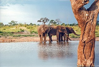
Hwange National Park is the largest natural reserve in Zimbabwe. It is around 14,600 sq km in area. It lies in the northwest of the country, just off the main road between Bulawayo and Victoria Falls. The nearest town is Dete. Histories of the region's pre-colonial days and its development as a game reserve and National Park are available online

Kuruman is a small town with just over 13,000 inhabitants in the Northern Cape province of South Africa. It is known for its scenic beauty and the Eye of Kuruman, a geological feature that brings water from deep underground. The abundance of water produces an unexpected swathe of green amidst the barren plains and is known as the Oasis of the Kalahari. It was at first a mission station of the London Missionary Society founded by Robert Moffat in 1821. It was also the place where David Livingstone arrived for his first position as a missionary in 1841. The Kuruman River, which is dry except for flash floods after heavy rain, is named after the town.

The Highveld is the portion of the South African inland plateau which has an altitude above roughly 1500 m, but below 2100 m, thus excluding the Lesotho mountain regions to the south-east of the Highveld. It is home to some of the country's most important commercial farming areas, as well as its largest concentration of metropolitan centres, especially the Gauteng conurbation, which accommodates one-third of South Africa's population.

Chobe National Park is Botswana's first national park, and also the most biologically diverse. Located in the north of the country, it is Botswana's third largest park, after Central Kalahari Game Reserve and Gemsbok National Park, and has one of the greatest concentrations of game in all of Africa.

Ghanzi is a district in western Botswana, bordering Namibia in the west and extending east into much of the interior of the country. The district's administrative centre is the town of Ghanzi. Most of the eastern half of Ghanzi makes up the Central Kalahari Game Reserve. The human population at the 2001 census was 43,370, less populous than that of any other district in Botswana. Ghanzi's area is 117,910 km².
Kgalagadi Transfrontier Park is a large wildlife preserve and conservation area in southern Africa.

The Makgadikgadi Pan, a salt pan situated in the middle of the dry savanna of north-eastern Botswana, is one of the largest salt flats in the world. The pan is all that remains of the formerly enormous Lake Makgadikgadi, which once covered an area larger than Switzerland, but dried up tens of thousands of years ago. Recent studies of human mitochondrial DNA suggest that modern Homo sapiens first began to evolve in this region some 200,000 years ago, when it was a vast, exceptionally fertile area of lakes, rivers, marshes, woodlands and grasslands especially favorable for habitation by evolving hominins and other mammals.

The Kalahari Basin, also known as the Kalahari Depression or the Okavango Basin, is an endorheic basin and large lowland area covering over 2.5 million km2 covering most of Botswana and Namibia, as well as parts of Angola, South Africa, Zambia, and Zimbabwe. The outstanding physical feature in the basin, and occupying the centre, is the large Kalahari Desert.

The Madikwe Game Reserve is a protected area in South Africa, part of the latest park developments in the country. Named after the Madikwe or Marico River, on whose basin it is located, it was opened in 1991 and comprises 750 km² of bushland north of the small town Groot-Marico up to the Botswana border.

The wildlife of Botswana refers to the flora and fauna of this country. Botswana is around 90% covered in savanna, varying from shrub savanna in the southwest in the dry areas to tree savanna consisting of trees and grass in the wetter areas. Even under the hot conditions of the Kalahari Desert, many different species survive; in fact the country has more than 2500 species of plants and 650 species of trees. Vegetation and its wild fruits are also extremely important to rural populations living in the desert and are the principal source of food, fuel and medicine for many inhabitants.

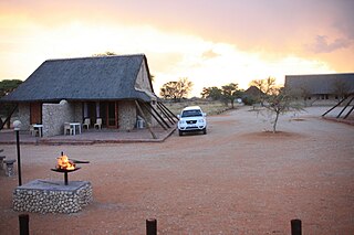
Botswana's principal tourist attractions are its game reserves, with hunting and photographic safaris available. Other attractions include the Okavango Delta region, which during the rainy season is a maze of waterways, islands, and lakes. The tourism industry also helped to diversify Botswana's economy from traditional sources such as diamonds and beef and created 23,000 jobs in 2005.
The Kalahari Acacia-Baikiaea woodlands are an ecoregion located in Botswana, northern Namibia, South Africa and Zimbabwe.
Olifantshoek is a town in John Taolo Gaetsewe District Municipality in the Northern Cape Province of South Africa.

Lower Sabie is one of Kruger National Park's Main rest camps and is situated on the southern bank of the Sabie River, in the southeastern section of the park. It is connected to the main Skukuza camp by the H4-1 tarred road, which is often considered to be the busiest road in the park.
Ancestral land conflict over the Central Kalahari Game Reserve (CKGR) arose in the 1970s between the government of Botswana and the San people (Bushmen), and is ongoing, resulting in one of the most expensive court cases in the history of Botswana.
WildEarth is a British-South African broadcasting and conservation company primarily based at Djuma Game Reserve, part of the Sabi Sand Game Reserve in South Africa, who focus on connecting people with African Wildlife. The company is best known for its live drives, which take place twice a day in Sabi Sands and Pridelands. Former locations included Tswalu Kalahari, Karongwe Private Game Reserve, Phinda, Ngala and Arathusa.
