Kiboga

Last updated
Kiboga
Kiboga Municipality
Uganda location map.svg
Red pog.svg
Kiboga
Location in Uganda
Coordinates: 00°55′12″N31°45′36″E / 0.92000°N 31.76000°E / 0.92000; 31.76000
Country Flag of Uganda.svg Uganda
Region Central Region
District Kiboga District
Elevation
3,870 ft (1,180 m)
Population
 (2020 Estimate)
  Total22,400 [1]

Kiboga is a town in the Central Region of Uganda. It is the main municipal, administrative, and commercial center of Kiboga District, and the district headquarters are located there. [2]

Contents

Location

Kiboga is located approximately 123 kilometres (76 mi) northwest of Kampala, Uganda's largest city, on the all-weather tarmac Kampala–Hoima Road. [3] This is about 79 kilometres (49 mi), by road, southeast of Hoima, the center of Uganda's petrochemical industry. [4] The geographical coordinates of Kiboga Town Council are 0°55'03.0"N, 31°45'36.0"E (Latitude:0.9175; Longitude:31.7600). [5]

Population

The population of Kiboga was estimated at 12,000 during the 2002 national population census. In 2010, the Uganda Bureau of Statistics (UBOS) estimated the population at 16,600. In 2011, UBOS estimated the mid-year population at 17,400. [6] During the 2014 national population census, the population was enumerated at 19,591. [7]

In 2015, UBOS estimated the population of Kiboga Town Council at 19,700. In 2020, the statistics agency estimated the mid-year population of the town at 22,400 inhabitants. Of these, 11,500 (51.3 percent) were females and 10,900 (48.7 percent) were males. UBOS calculated that the population of Kiboga Town expanded at an average rate of 2.6 percent annually, between 2015 and 2020. [1]

Historical population
YearPop.±%
200212,000    
201016,600+38.3%
201117,400+4.8%
201419,591+12.6%
201519,700+0.6%
202022,400+13.7%
source: [1] [6] [7]

Points of interest

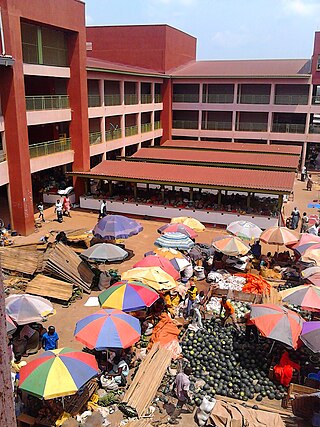
The following points of interest are found in or near the town of Kiboga: (a) the headquarters of Kiboga District Administration (b) the offices of Kiboga Town Council and (c) Kiboga Central Market. [5]

Kiboga General Hospital, a 100-bed public hospital, administered by the Uganda Ministry of Health is located in the middle of town. [8] The Kampala-Hoima Road, passes through the middle of town in a northwest–southeast direction. [9]

Related Research Articles

<span class="mw-page-title-main">Masindi</span> Place in Western Region of Uganda, Uganda

Masindi is a town in the Western Region of Uganda. It is on the road between Kampala and the Murchison Falls National Park. It is the site of the headquarters of the Masindi District.
<span class="mw-page-title-main">Hoima</span> District capital in Western Region, Uganda

Hoima is a city in the Western Region of Uganda. It is the main municipal, administrative, and commercial center of Hoima District. It is also the location of the palace of the Omukama of Bunyoro.

Sembabule is a town in Sembabule District in the Central Region of Uganda. The town is the main municipal, administrative, and commercial center of the district and the site of the district headquarters.

<span class="mw-page-title-main">Kayunga</span> Place in Central Region of Uganda, Uganda

Kayunga is a town in the Central Region of Uganda. It is the main municipal, administrative, and commercial center of Kayunga District.

<span class="mw-page-title-main">Mpigi</span> Place in Central Uganda, Uganda

Mpigi is a town in Mawokota County, Mpigi District, in Central Uganda. Mpigi is the municipal, administrative and commercial headquarters of Mpigi District. The district is named after the town.

<span class="mw-page-title-main">Luweero</span> Place in Central Region of Uganda, Uganda

Luweero is a town in the Central Region of Uganda. It is the main municipal, administrative, and commercial center of Luweero District.

Butaleja is a town in Eastern Region of Uganda. It is the district headquarters and the main municipal, administrative and commercial center of Butaleja District. The district is named after the town.

<span class="mw-page-title-main">Kakiri</span> Settlement in Central Uganda

Kakiri is a town located in Wakiso District in the Central Region of Uganda. Kakiri is the site of the headquarters of the first division of the Uganda People's Defence Force (UPDF). It is also the hometown of Gilbert Bukenya, who represents the town and the surrounding constituency of Busiro North in the parliament of Uganda and is a former vice president of Uganda.

<span class="mw-page-title-main">Wakiso Town</span> Place in Central Region, Uganda

Wakiso is a city in the Central Region of Uganda. It is the headquarters of Wakiso District.

Buliisa, also Bulisa, is a town in the Western Region of Uganda. It is the site of the headquarters of the Buliisa District. Neighborhoods within Buliisa Municipality include Wanseko and Kasenyi.

Isingiro is a town in the Western Region of Uganda. It is the main municipal, administrative, and commercial center of Isingiro District and the site of the district's headquarters.

<span class="mw-page-title-main">Lyantonde</span> Place in Central Region of Uganda, Uganda

Lyantonde is a town in the southern part of the Central Region of Uganda. It is the main municipal, administrative, and commercial center of Lyantonde District.

<span class="mw-page-title-main">Nansana</span> Place in Central Region, Uganda

Nansana is a town in the Central Region of Uganda. It is located in the Wakiso District and is one of the five municipalities in the district. Nansana is a municipal council comprising four Divisions; Nansana Division, Nabweru Division, Gombe Division, and Busukuma Divisions. The four Divisions are considered as lower local government independent units.

<span class="mw-page-title-main">Busolwe</span> Place in Eastern Uganda, Uganda

Busolwe is a town in the Eastern Region of Uganda. It is one of the two municipalities in Butaleja District, the other being Butaleja.

<span class="mw-page-title-main">Kaabong</span> Ugandan town

Kaabong is a town in the Northern Region of Uganda. It is the chief municipal, administrative and commercial center of the eponymous Kaabong District, and the district headquarters are located in the town.

Kagadi is a town in the Western Region of Uganda. It is the commercial and administrative headquarters of Kagadi District.

Kyegegwa is a town in the Western Region of Uganda. It is the main municipal, administrative, and commercial center of Kyegegwa District.

Bukomero is a town in Ssingo County, Kiboga District, in the Central Region of Uganda.

Masulita is a town in Wakiso District in the Central Region of Uganda. As of April 2021 Masulita is one of four town councils in the district.

Namayumba is a settlement in the Wakiso District in the Buganda Region of Uganda. The name also refers to "Namayumba sub-county", the location of Namayumba settlement.

References

  1. 1 2 3 Uganda Bureau of Statistics (14 June 2020). "The population development of Kiboga as well as related information and services" (Citypopulation.de Quoting Uganda Bureau of Statistics). Citypopulation.de. Retrieved 17 June 2021.
  2. Nelson Kiva (2 March 2011). "Brawl Over New Street Erupts in Kiboga". Uganda Radio Network . Retrieved 17 June 2021.
  3. "Road Distance Between Kampala, Uganda And Kiboga, Uganda" (Map). Google Maps . Retrieved 17 June 2021.
  4. "Road Distance Between Hoima, Uganda And Kiboga, Uganda" (Map). Google Maps . Retrieved 17 June 2021.
  5. 1 2 "Location of Kiboga Town Council, Uganda" (Map). Google Maps . Retrieved 17 June 2021.
  6. 1 2 Uganda Bureau of Statistics (2012). "Estimated Population of Kiboga In 2002, 2010 & 2011" (PDF). Kampala: Uganda Bureau of Statistics. Archived from the original (Archived from the original on 7 July 2014) on 2014-07-07. Retrieved 17 June 2021.
  7. 1 2 UBOS (27 August 2014). "The Population of The Regions of the Republic of Uganda And All Cities And Towns of More Than 15,000 Inhabitants". Citypopulation.de Quoting Uganda Bureau of Statistics (UBOS). Retrieved 26 February 2015.
  8. "Location of Kiboga General Hospital" (Map). Google Maps . Retrieved 17 June 2021.
  9. "Kampala–Hoima Road Passes Through Kiboga Town Council" (Map). Google Maps . Retrieved 17 June 2021.

00°55′12″N31°45′36″E / 0.92000°N 31.76000°E / 0.92000; 31.76000