
Çorum is a northern Anatolian city that is the capital of the Çorum Province of Turkey. Çorum is located inland in the central Black Sea Region of Turkey, and is approximately 244 km (152 mi) from Ankara and 608 km (378 mi) from Istanbul. The city has an elevation of 801 m (2,628 ft) above sea level, a surface area of 12,820 km2 (4,950 sq mi), and as of the 2016 census, a population of 237,000.
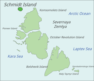
Schmidt Island is one of the islands of the Severnaya Zemlya group in the Russian Arctic and was named after Soviet scientist and first head of the Chief Directorate of the Northern Sea Route, Otto Schmidt. It is located at the far northwestern end of the archipelago and lies slightly south of the Arctic Cape on Komsomolets Island.

St Keyne is a village in the civil parish of St Keyne and Trewidland, in east Cornwall, England, United Kingdom. The parish lies between the parishes of Liskeard and Duloe. The parish population at the 2011 census was 492.

Adıyaman is a city in southeastern Turkey, and the capital of the Adıyaman Province. Its inhabitants are mostly Kurdish.

Güicán is a town and municipality in the Colombian Department of Boyacá. It is close to the national natural park El Cocuy National Park.
Malchow is an Amt in the Mecklenburgische Seenplatte district, in Mecklenburg-Vorpommern, Germany. The seat of the Amt is in Malchow.

Batang Melaka is a mukim and town in Jasin District, Malacca, Malaysia. Located at the Negeri Sembilan state border, part of the town itself is within Negeri Sembilan. It is about 52 kilometers from Melaka Sentral and is connected by the Panorama Bus through Durian Tunggal and Selandar. Batang Melaka has a small police station, a Chinese and Tamil government school, a town hall, a Salvation Army Corps centre, and one main road passing in the middle of the town.
Extreme geographical points of Slovenia:
Lipiny Dolne is a village in the administrative district of Gmina Potok Górny, within Biłgoraj County, Lublin Voivodeship, in eastern Poland. It lies approximately 9 kilometres (6 mi) north-west of Potok Górny, 24 km (15 mi) south-west of Biłgoraj, and 93 km (58 mi) south of the regional capital Lublin.
Lipiny Górne-Borowina is a village in the administrative district of Gmina Potok Górny, within Biłgoraj County, Lublin Voivodeship, in eastern Poland. It lies approximately 9 kilometres (6 mi) north-west of Potok Górny, 24 km (15 mi) south-west of Biłgoraj, and 93 km (58 mi) south of the regional capital Lublin.
Rawicz is a village in the administrative district of Gmina Drużbice, within Bełchatów County, Łódź Voivodeship, in central Poland. It lies approximately 2 kilometres (1 mi) east of Drużbice, 12 km (7 mi) north of Bełchatów, and 36 km (22 mi) south of the regional capital Łódź.
Pieścidła is a village in the administrative district of Gmina Naruszewo, within Płońsk County, Masovian Voivodeship, in east-central Poland. It lies approximately 19 kilometres (12 mi) south of Płońsk and 49 km (30 mi) north-west of Warsaw.
Sô-Ava is a town, arrondissement, and commune in the Atlantique Department of southern Benin. The commune covers an area of 218 square kilometres and as of 2002 had a population of 76,315 people.
Mäepea is a village in Kuusalu Parish, Harju County in northern Estonia.
Aresi is a village in Sõmeru Parish, Lääne-Viru County, in northeastern Estonia.
Ganvié I is an arrondissement in the Atlantique Department of southern Benin. It is an administrative division under the jurisdiction of the commune of Sô-Ava. According to the population census conducted by the Institut National de la Statistique Benin on February 15, 2002, the arrondissement had a total population of 10,280.

North Danger Reef is one of the seven major reefs / banks / etc. in the Spratly Islands area of the South China Sea. It is the most North Western of the features of the Spratly Islands, located to the NW of Dangerous Ground.
This page is based on this
Wikipedia article Text is available under the
CC BY-SA 4.0 license; additional terms may apply.
Images, videos and audio are available under their respective licenses.
