
The Archdiocese of Poznań is one of 14 archdioceses located in Poland, with the seat located in Poznań.
Kołczyn-Kolonia is a village in the administrative district of Gmina Rokitno, within Biała Podlaska County, Lublin Voivodeship, in eastern Poland, close to the border with Belarus.

Rakówka is a village in the administrative district of Gmina Księżpol, within Biłgoraj County, Lublin Voivodeship, in eastern Poland. It lies approximately 6 kilometres (4 mi) east of Księżpol, 17 km (11 mi) south of Biłgoraj, and 95 km (59 mi) south of the regional capital Lublin.
Chechło Pierwsze is a village in the administrative district of Gmina Dobroń, within Pabianice County, Łódź Voivodeship, in central Poland. It lies approximately 4 kilometres (2 mi) east of Dobroń, 6 km (4 mi) west of Pabianice, and 19 km (12 mi) south-west of the regional capital Łódź.
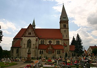
Poznań is a village in the administrative district of Gmina Serokomla, within Łuków County, Lublin Voivodeship, in eastern Poland. It lies approximately 4 kilometres (2 mi) south-west of Serokomla, 28 km (17 mi) south of Łuków, and 52 km (32 mi) north of the regional capital Lublin.
Kózki is a village in the administrative district of Gmina Skalbmierz, within Kazimierza County, Świętokrzyskie Voivodeship, in south-central Poland. It lies approximately 4 kilometres (2 mi) south of Skalbmierz, 7 km (4 mi) north-west of Kazimierza Wielka, and 67 km (42 mi) south of the regional capital Kielce.
Myczków is a village in the administrative district of Gmina Solina, within Lesko County, Subcarpathian Voivodeship, in south-eastern Poland. It lies approximately 5 kilometres (3 mi) west of Solina, 13 km (8 mi) south-east of Lesko, and 79 km (49 mi) south of the regional capital Rzeszów.
Strękowo-Nieczykowskie is a village in the administrative district of Gmina Nur, within Ostrów Mazowiecka County, Masovian Voivodeship, in east-central Poland. It lies approximately 5 kilometres (3 mi) north of Nur, 29 km (18 mi) east of Ostrów Mazowiecka, and 104 km (65 mi) north-east of Warsaw.
Zastronie is a village in the administrative district of Gmina Szydłowiec, within Szydłowiec County, Masovian Voivodeship, in east-central Poland.
Jezierzyce Kościelne is a village in the administrative district of Gmina Włoszakowice, within Leszno County, Greater Poland Voivodeship, in west-central Poland. It lies approximately 6 kilometres (4 mi) south-east of Włoszakowice, 12 km (7 mi) west of Leszno, and 67 km (42 mi) south-west of the regional capital Poznań.
Kopaszyce is a village in the administrative district of Gmina Dominowo, within Środa Wielkopolska County, Greater Poland Voivodeship, in west-central Poland.
Babice is a village in the administrative district of Gmina Nędza, within Racibórz County, Silesian Voivodeship, in southern Poland. It lies approximately 3 kilometres (2 mi) south of Nędza, 8 km (5 mi) north-east of Racibórz, and 52 km (32 mi) west of the regional capital Katowice.
Ligota Bialska is a village in the administrative district of Gmina Biała, within Prudnik County, Opole Voivodeship, in south-western Poland. It lies approximately 2 kilometres (1 mi) north-east of Biała Prudnicka, 13 km (8 mi) north-east of Prudnik, and 34 km (21 mi) south-west of the regional capital Opole.
Kozy is a village in the administrative district of Gmina Lipnica, within Bytów County, Pomeranian Voivodeship, in northern Poland. It lies approximately 8 kilometres (5 mi) north of Lipnica, 10 km (6 mi) south-west of Bytów, and 87 km (54 mi) south-west of the regional capital Gdańsk.
Głusino, is a village in the administrative district of Gmina Kartuzy, within Kartuzy County, Pomeranian Voivodeship, in northern Poland. It lies approximately 11 kilometres (7 mi) north-west of Kartuzy and 36 km (22 mi) west of the regional capital Gdańsk.
Piekiełko is a settlement in the administrative district of Gmina Przodkowo, within Kartuzy County, Pomeranian Voivodeship, in northern Poland. It lies approximately 4 kilometres (2 mi) north of Przodkowo, 11 km (7 mi) north-east of Kartuzy, and 23 km (14 mi) west of the regional capital Gdańsk.
Czarny Młyn is a settlement in the administrative district of Gmina Puck, within Puck County, Pomeranian Voivodeship, in northern Poland. It lies approximately 14 kilometres (9 mi) north-west of Puck and 54 km (34 mi) north-west of the regional capital Gdańsk.
Kalina is a settlement in the administrative district of Gmina Braniewo, within Braniewo County, Warmian-Masurian Voivodeship, in northern Poland, close to the border with the Kaliningrad Oblast of Russia. It lies approximately 5 kilometres (3 mi) north-east of Braniewo and 81 km (50 mi) north-west of the regional capital Olsztyn.
Katkajmy is a village in the administrative district of Gmina Kętrzyn, within Kętrzyn County, Warmian-Masurian Voivodeship, in northern Poland. It lies approximately 6 kilometres (4 mi) west of Kętrzyn and 63 km (39 mi) north-east of the regional capital Olsztyn.
Porębek is a village in the administrative district of Gmina Kętrzyn, within Kętrzyn County, Warmian-Masurian Voivodeship, in northern Poland. It lies approximately 6 kilometres (4 mi) west of Kętrzyn and 63 km (39 mi) north-east of the regional capital Olsztyn.


