
The Meuse or Maas is a major European river, rising in France and flowing through Belgium and the Netherlands before draining into the North Sea from the Rhine–Meuse–Scheldt delta. It has a total length of 925 km.

The Rhine is one of the major European rivers. The river begins in the Swiss canton of Graubünden in the southeastern Swiss Alps. It forms part of the Swiss-Liechtenstein, Swiss-Austrian, and Swiss-German borders. After that the Rhine defines much of the Franco-German border, after which it flows in a mostly northerly direction through the German Rhineland. Finally in Germany, the Rhine turns into a predominantly westerly direction and flows into the Netherlands where it eventually empties into the North Sea. It drains an area of 9,973 sq km and its name derives from the Celtic Rēnos. There are also two German states named after the river, North Rhine-Westphalia and Rhineland-Palatinate.

The Waal is the main distributary branch of the river Rhine flowing approximately 80 km (50 mi) through the Netherlands. It is the major waterway connecting the port of Rotterdam to Germany. Before it reaches Rotterdam, it joins with the Afgedamde Maas near Woudrichem to form the Boven Merwede. Along its length, Nijmegen, Tiel, Zaltbommel and Gorinchem are towns of importance with direct access to the river.

Gelderland, also known as Guelders in English, is a province of the Netherlands, occupying the centre-east of the country. With a total area of 5,136 km2 (1,983 sq mi) of which 173 km2 (67 sq mi) is water, it is the largest province of the Netherlands by land area, and second by total area. Gelderland shares borders with six other provinces and the German state of North Rhine-Westphalia.

Maasdriel is a municipality in the province of Gelderland, in the eastern Netherlands.
A kill is a body of water, most commonly a creek, but also a tidal inlet, river, strait, or arm of the sea. The term is derived from the Middle Dutch kille, meaning "riverbed" or "water channel". It is found in areas of Dutch influence in the Netherlands' former North American colony of New Netherland, primarily the Hudson and Delaware Valleys.

The Bijlands Kanaal is a canal in the Dutch province of Gelderland, near the Dutch-German border. It is currently by far the most important river-stretch of the Rhine when that major river enters the Netherlands.

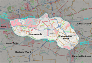
The Hoekse Waard is an island between the Oude Maas, Dordtsche Kil, Hollands Diep, Haringvliet and Spui rivers in the province of South Holland in the Netherlands. The island, part of the namesake municipality of Hoeksche Waard, is a mostly agricultural region, south of the outskirts of Rotterdam. The Hoeksche Waard consists of reclaimed land (polders): after the Saint Elisabeth flood of 1421 most of the area was flooded. The land has been reclaimed gradually in the following centuries.

Bommelerwaard is a district in Gelderland, Netherlands.
Sandsvær is a area in Kongsberg, Viken county, Norway. The area is identical to the former municipality in Buskerud county named Sandsvær. Sandsvær is situated in the valley of Lågendalen on the Numedalslågen river, and is bordered by Kongsberg town in the north, and the county border to Vestfold og Telemark county in the south.

Kerkdriel is a town in the Dutch province of Gelderland. It is a part of the municipality of Maasdriel, and lies about 8 km north of 's-Hertogenbosch.

Hurwenen is a village in the Dutch province of Gelderland. It is a part of the municipality of Maasdriel, and lies about 11 km southwest of Tiel. Thijs Straver is the mayor of Hurwenen.

The Rhine–Meuse–Scheldt delta is a river delta in the Netherlands formed by the confluence of the Rhine, the Meuse and the Scheldt rivers. In some cases, the Scheldt delta is considered a separate delta to the Rhine–Meuse delta. The result is a multitude of islands, branches and branch names that may at first sight look bewildering, especially as a waterway that appears to be one continuous stream may change names as many as seven times, e.g. Rhine → Bijlands Kanaal → Pannerdens Kanaal → Nederrijn → Lek → Nieuwe Maas → Het Scheur → Nieuwe Waterweg. Since the Rhine contributes most of the water, the shorter term Rhine Delta is commonly used. However, this name is also used for the delta where the Alpine Rhine flows into Lake Constance, so it is clearer to call the larger one Rhine–Meuse delta, or even Rhine–Meuse–Scheldt delta, as the Scheldt ends in the same delta. By some calculations, the delta covers 25,347 km2 (9,787 sq mi), making it the largest in Europe.

The Oude Maas is a distributary of the river Rhine, and a former distributary of the river Maas, in the Dutch province of South Holland. It begins at the city of Dordrecht where the Beneden Merwede river splits into the Noord and the Oude Maas. It ends when it joins the Nieuwe Maas to form Het Scheur.

Schenkenschanz is a small community in North Rhine-Westphalia, Germany that was incorporated into the town of Kleve (Cleves) in 1969. Schenkenschanz is site of the former Schenkenschans fortress that was of significance in the Dutch Revolt.
Veur-Lent is the name of an island in the Dutch river Waal. This city island is part of the municipality of Nijmegen, it is situated in the Lent Quarter, north of the city center.
The Waaltje is a dammed river in the western Netherlands, southeast of Rotterdam. Historically it used to be the western end of the Waal river, hence its official name continues to be Waal, although the intermediate Waal sections, Boven Merwede, Beneden Merwede, and a subsection of the Noord, have long changed their names.
Gerard P. van den Anker is a Dutch politician, who served as a member of the House of Representatives between January and March 2021. He is a member of the Christian Democratic Appeal (CDA).
