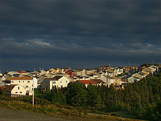
Paradise is a town on the Avalon Peninsula in the province of Newfoundland and Labrador, Canada. Paradise is the third largest settlement in the province and is part of the St. John's metropolitan area, the 20th largest metropolitan area in Canada. The town borders the City of St. John's, the City of Mount Pearl, the Town of Portugal Cove-St. Philip's, and the town of Conception Bay South. According to the 2016 census the population of Paradise is 21,389, after recording a 21% increase in population over five years.

Kilbride is a defunct provincial electoral district for the House of Assembly of Newfoundland and Labrador, Canada. As of 2011, there are 10,251 eligible voters living within the district. The district was abolished in 2015 and replaced by Waterford Valley.

St. John's South is a defunct provincial electoral district for the House of Assembly of Newfoundland and Labrador, Canada. As of its final contest in 2011, there were 7,923 eligible voters living within the district.

Ferryland is a provincial electoral district for the House of Assembly of Newfoundland and Labrador, Canada. As of 2011, there are 8,571 eligible voters living within the district.
Goulds is a designated place in the Canadian province of Newfoundland and Labrador. It is a rural neighbourhood within the City of St. John's southeast of the city centre.

Rabbittown is a neighbourhood in St. John's, Newfoundland and Labrador. It is located near downtown, and is bounded approximately by Empire Avenue, Freshwater Road and Newtown Road.
Aquaforte is a town on the south shore of Newfoundland's Avalon Peninsula in the province of Newfoundland and Labrador, Canada.

Fort Amherst is a neighbourhood in St. John's, Newfoundland and Labrador. It is located at 47°33′48.96″N52°40′49.60″W, on the southern side of the Narrows, the entrance to St. John's harbour. Apart from some family dwellings, Fort Amherst consists of a man-made harbour, a lighthouse and the remains of gun emplacements built during World War II to defend against German U-boats. Two QF 4.7-inch B Mark IV* guns remain in place on their mountings.

Georgestown is a Neighbourhood Improvement Area in St. John's, Newfoundland and Labrador a short distance north from downtown of St. John's. This was established in the 1970s as part of an effort by Federal and local government to improve inner cities. Originally what was known as Georgestown village was much smaller and only "extended from Donnelly's Lane to what is now Belvedere Street". The neighbourhood improvement area includes, in addition to the original Georgestown, the former Monkstown and Tubridtown, along with adjoining land, including Circular Road, and Belvedere Street as well as some other parts of the former Belvedere Estate. It is bordered by Military Road, Monkstown Road, Empire Avenue, a small part of Carpasian Road, the east side of Bonaventure Avenue, and Holy Heart and Brother Rice Schools to the west. It was settled, around 1819, as the city's first suburb. The name is an evolution of "George (Winter)'s Town", as it was known in the 19th century.

The LSPU Hall is a large wooden structure in St. John's, Newfoundland and Labrador. Located on 3 Victoria Street it is currently the home of the Resource Centre for the Arts (RCA). The name comes from a previous owner, the Longshoremen's Protective Union. The Hall is a registered heritage building.

The Battery is a neighbourhood within the city of St. John's, Newfoundland and Labrador that sits on the entrance to the harbour, on the slopes of Signal Hill. It is sometimes described as an outport within the city of St. John's and is noted for its steep slopes, and colourful houses. The Battery has been the site, over the centuries, for gun emplacements (batteries), such as Fort Waldegrave, for the defence of St. John's Harbour, including during both World Wars.
The neighbourhood of Pleasantville in St. John's, Newfoundland and Labrador is located in the east end of the city, directly north of the downtown. The neighbourhood extends from the north side of Quidi Vidi Lake northward to Newfoundland Drive, and is largely made up of apartment blocks.
Virginia Park is a neighbourhood in the northeast end of St. John's, Newfoundland and Labrador.
The neighbourhood of Churchill Park in St. John's, Newfoundland and Labrador is located in the city's east end. The neighbourhood is bordered by Freshwater Road to the west, Empire Avenue to the south, Kenna's Hill, Kingsbridge and Torbay Roads to the east and Elizabeth Avenue to the north. Its main east-west thoroughfares are Elizabeth Avenue and Empire Avenue, and its main north-south thoroughfares are Portugal Cove Road and Allandale Road. The neighbourhood borders the campus of Memorial University of Newfoundland to the north, and as a result, it is home to a sizable student population. The area is made up of single-family homes, mostly built in the 1950s and 1960s.
Clovelly Trails is a neighbourhood located in the northeast end of St. John's, Newfoundland and Labrador.

Bally Haly Golf & Curling Club, is a semi-private curling club and golf course located in St. John's, Newfoundland and Labrador, Canada. It is the oldest golf club in Atlantic Canada, having been founded in 1896. In that year, a group of ten prominent Newfoundland gentlemen formed the Newfoundland Golf Club.
The neighbourhood of Buckmaster's Circle is located in central area of St. John's, Newfoundland and Labrador, Canada.
Fort Waldegrave was a battery or an emplacement for heavy guns in St. John’s Newfoundland, strategically overlooking the Narrows and St John’s Harbour.

Mount Scio is a provincial electoral district in Newfoundland and Labrador. As of 2011 there are 14,482 people living in the district.
Division No. 1, Subdivision U is an unorganized subdivision on the Avalon Peninsula in Newfoundland and Labrador, Canada, in Division 1. It contains the unincorporated communities of Admiral's Cove, Bauline East, Bauline South, Burnt Cove, Devils Kitchen, Flat Rock, St. Michaels and Seal Cove.