
Kildare
Location of Kildare in Prince Edward Island
Kildare (Irish : Cill Dara, meaning "church of the oak") is a settlement in Prince Edward Island. [1] It was named after Kildare in Ireland. [2]
Kildare (Irish : Cill Dara, meaning "church of the oak") is a settlement in Prince Edward Island. [1] It was named after Kildare in Ireland. [2]

The Gulf of St. Lawrence is the outlet of the North American Great Lakes via the St. Lawrence River into the Atlantic Ocean. The gulf is a semi-enclosed sea, covering an area of about 226,000 square kilometres (87,000 sq mi) and containing about 34,500 cubic kilometres (8,300 cu mi) of water, which results in an average depth of 152 metres (499 ft).

Cape Tormentine is a local service district in southeastern New Brunswick, Canada. It is located on the Northumberland Strait at the Abegweit Passage, the shortest crossing between Prince Edward Island and the mainland. It once flourished as a transportation hub between New Brunswick and Prince Edward Island but has been in decline since 1997 when the ferry service was closed due to the opening of the Confederation Bridge. At the Canada 2011 Census the population was 108, three quarters what it was at the 2006 census.

Foxley River is a Canadian rural community in Prince County, Prince Edward Island.
St. Felix is a municipality that holds community status in Prince Edward Island, Canada. It is located in Prince County, 4 km (2.5 mi) south of Tignish.

Prince County is located in western Prince Edward Island, Canada. The county's defining geographic feature is Malpeque Bay, a sub-basin of the Gulf of St. Lawrence, which creates the narrowest portion of Prince Edward Island's landmass, an isthmus upon which the city of Summerside is located.
Murray Harbour is a municipality that holds rural municipality status in Prince Edward Island, Canada. It is located in southeastern Kings County.
Miminegash is a municipality that holds community status in Prince Edward Island, Canada. It is located 8 miles (13 km) northwest of Alberton and 11 miles (18 km) southwest of Tignish. It is part of a small area in Lot 3 known as either the St. Louis, Palmer Road, or Miminegash area. This area is often associated with Tignish due to the shared Acadian roots between these areas.
Morell is a municipality that holds community status in Prince Edward Island, Canada. It is located in Kings County east of Bristol.
Ascension Road, labelled Route 160, is a 2-lane collector highway in western Prince County, Prince Edward Island, Canada. It is located 2 miles (3.2 km) NW of the community of Tignish. Its maximum speed limit is 80 kilometres per hour (50 mph).
Pridham Road, labelled Route 154, is a 2-lane collector highway in western Prince County, Prince Edward Island, Canada. It is near the town of Alberton. Its maximum speed limit is 80 km/h (50 mph).
Wellington is a municipality that holds community status in Prince Edward Island, Canada. It is located in Prince County, and extends as Wellington Centre onto Route 2 from Richmond through to St. Nicholas.

Tignish-Palmer Road is a provincial electoral district for the Legislative Assembly of Prince Edward Island, Canada. It was formerly Tignish-DeBlois from 1996 to 2007.
The Hunter River, informally nicknamed the "River Clyde", is a Canadian river in northwestern Queens County, Prince Edward Island.
Cascumpec Bay is within Prince Edward Island in Canada and is adjacent to the Gulf of Saint Lawrence.
Central Kildare is a settlement in Prince Edward Island. It is located a few kilometres north of Alberton, Prince Edward Island.
Greenmount is a municipality that holds community status in Prince Edward Island, Canada.
Kildare Capes is a settlement on Prince Edward Island. It was named after Kildare in Ireland.
Mont Carmel is a Canadian unincorporated area in Prince County, Prince Edward Island. The community is located in the "Evangeline Region" which is a cluster of Acadian communities in the central part of Prince County. The village is home to the Notre-dame-du-Mont-Carmel, a massive 450000-brick Catholic church built in 1898.
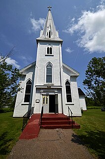
St. Brigid's Church is a Roman Catholic church in Foxley River, PEI, Canada. It is part of the Roman Catholic diocese of Charlottetown
Collège de l'Île is a Francophone post-secondary community college in the Canadian province of Prince Edward Island with headquarters in the community of Wellington. It was originally a campus of Collège de l'Acadie which served Nova Scotia and Prince Edward Island. When the Nova Scotia operations became part of Université Sainte-Anne, its operations in Prince Edward Island were renamed Collège Acadie Î.-P.-É and subsequently Collège de l'Île.
| | This Prince Edward Island location article is a stub. You can help Wikipedia by expanding it. |