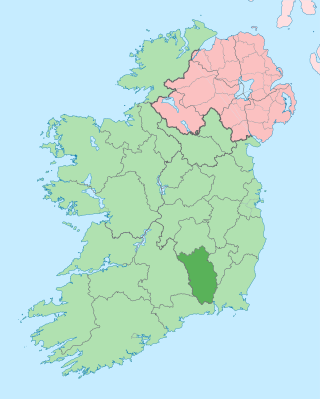
County Kilkenny is a county in Ireland. It is in the province of Leinster and is part of the Southern Region. It is named after the city of Kilkenny. Kilkenny County Council is the local authority for the county. At the 2022 census the population of the county was 103,685. The county was based on the historic Gaelic kingdom of Ossory (Osraighe), which was coterminous with the Diocese of Ossory.

County Waterford is a county in Ireland. It is in the province of Munster and is part of the Southern Region. It is named after the city of Waterford. Waterford City and County Council is the local authority for the county. The population of the county at large, including the city, was 127,363 according to the 2022 census. The county is based on the historic Gaelic territory of the Déise. There is an Irish-speaking area, Gaeltacht na nDéise, in the southwest of the county.

The Barrow is a river in Ireland. It is one of The Three Sisters; the other two being the River Suir and the River Nore. The Barrow is the longest of the three rivers and, at 192 km (120 mi), the second-longest river in Ireland, behind the River Shannon. The catchment area of the River Barrow is 3,067 km2 before the River Nore joins it a little over 20 km before its mouth. The river's long term average flow rate, again before it is joined by River Nore, is 37.4 cubic metres per second. At the merger with the River Suir, its catchment area is ca. 5,500 km2 and its discharge over 80 m3/s.

The River Suir is a river in Ireland that flows into the Atlantic Ocean through Waterford after a distance of 185 kilometres (115 mi). The catchment area of the Suir is 3,610 km2. Its long-term average flow rate is 76.9 cubic metres per second (m3/s), about twice the flow of either the River Barrow or the River Nore before these join, but a little less than the Barrow's flow when it meets the Suir 20 km downstream.
Carrick-on-Suir is a town in County Tipperary, Ireland. It lies on both banks of the River Suir. The part on the north bank of the Suir lies in the civil parish of "Carrick", in the historical barony of Iffa and Offa East. The part on the south bank lies in the civil parish of Kilmolerin in the barony of Upperthird, County Waterford.

The River Nore is one of the principal rivers in the South-East Region of Ireland. The 140-kilometre-long (87 mi) river drains approximately 2,530 square kilometres (977 sq mi) of Leinster and Munster, that encompasses parts of three counties. Along with the River Suir and River Barrow, it is one of the constituent rivers of the group known as the Three Sisters.

Kilmacow is a small village and civil parish in County Kilkenny, Ireland. The townland of Kilmacow is south of the village.
Kilmoyler is a townland in the civil parish of Killardry in the barony of Clanwilliam, County Tipperary in Ireland. The townland is in the parish of 'Bansha and Kilmoyler' in the Roman Catholic Archdiocese of Cashel and Emly.

The Rice Bridge is the present city-centre bridge in Waterford, Ireland on the north side of the city. It was constructed in stages between 1982 and 1986, with an official opening of the first two lanes in 1984. It is named after Edmund Ignatius Rice. The Rice Bridge was constructed after the previous bridge was deemed unsafe.

Waterpark College is a secondary school in the city of Waterford, Ireland. The school was established in 1892 on the banks of the River Suir as Waterford's first Classical school, and provides a secondary education to boys and girls from Waterford City and County and the surrounding area.

The River Suir Bridge is a cable-stayed bridge over the River Suir in Ireland. It was built as part of the N25 Waterford Bypass, and opened to traffic on 19 October 2009, some ten months ahead of schedule. The Viking settlement at Woodstown was discovered during the project and the route of the southern approach roads was altered to preserve the site.

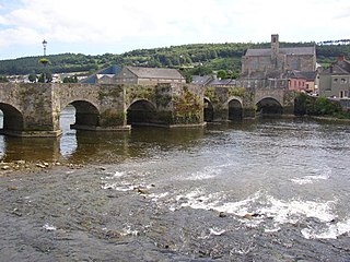
Fiddown is a small village in County Kilkenny, Ireland. It is located in the south of the county, just off the N24 road, 37 km (23 mi) south of Kilkenny city. The village is on the banks of the River Suir, near the border with County Waterford to which the village is connected via the Fiddown Bridge. Carrick-on-Suir is 7 km to the west, and Waterford city is 16 km to the east. The village is in a townland and civil parish of the same name.

The Nenagh River rises in the Silvermine Mountains in County Tipperary, Ireland. It flows east of Nenagh and into Lough Derg just north of Dromineer.

The River Ara is a river in County Tipperary, Ireland.
The Aherlow River is a river in County Limerick and County Tipperary, Ireland.
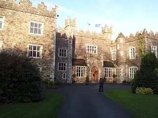
Waterford Castle is a historic house on Little Island in Waterford, Ireland. The house was owned by a branch of the Fitzgerald family for hundreds of years, but was developed into a hotel in the 1980s.

The River Derreen is a large river in the southeast of Ireland. It rises on the southern slopes of Lybagh and Slievemaan and flows southwest until it joins the River Slaney in County Carlow, south of Tullow, passing close to Hacketstown and Tullow, County Carlow before it joins the Slaney upstream of Aghade bridge. Running through tillage and pastureland in its lower reaches, the Derreen with its sandy, gravelly bottom is a prime salmon spawning tributary of the Slaney. Passing through counties Wicklow and Carlow, it is the first large, major tributary of the River Slaney.

The River Anner is a river in Ireland, flowing through County Tipperary, a tributary of the Suir.
Ballycamus or Ballycamusk is a townland in County Tipperary, Ireland. The River Suir forms its eastern boundary.
Corracleigh, an Anglicisation of the Gaelic, ‘Corr na Cloiche’ meaning The Round Hill of the Stone, is a townland in the civil parish of Templeport, County Cavan, Ireland. It lies in the Roman Catholic parish of Glangevlin and barony of Tullyhaw. The local pronunciation is Curracliff.
