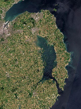
Strangford Lough is a large sea lough or inlet in County Down, in the east of Northern Ireland. It is the largest inlet in Ireland and the wider British Isles, covering 150 km2 (58 sq mi). The lough is almost fully enclosed by the Ards Peninsula and is linked to the Irish Sea by a long narrow channel at its southeastern edge. The main body of the lough has at least seventy islands along with many islets (pladdies), bays, coves, headlands and mudflats. Historically it was called 'Lough Coan', while 'Strangford' referred to the narrow sea channel. It is part of the 'Strangford and Lecale' Area of Outstanding Natural Beauty. Strangford Lough was designated as Northern Ireland's first Marine Conservation Zone in 2013, and has been designated a Special Area of Conservation for its important wildlife.

County Cavan is a county in Ireland. It is in the province of Ulster and is part of the Northern and Western Region. It is named after the town of Cavan and is based on the historic Gaelic territory of East Breffny (Bréifne). Cavan County Council is the local authority for the county, which had a population of 81,201 at the 2022 census.

Cavan is the county town of County Cavan in Ireland. The town lies in Ulster, near the border with County Fermanagh in Northern Ireland. The town is bypassed by the main N3 road that links Dublin with Enniskillen, Ballyshannon and Donegal Town.

Virginia is a town in County Cavan, Ireland. Founded in the 17th century as a plantation town, it now holds both local industry and commuter housing.

Bailieborough or Bailieboro is a town in County Cavan, Ireland. As of 2016, its population was 2,683, up from 1,529 as of the 1996 census. Bailieborough's proximity to the N3 national road has made it a commuter town.

Lough Ramor is a large natural lake of 741 hectares situated near Virginia, County Cavan. From early records Vita Tripartita identified as being in the territory of Cenal Muinreamhair. The literal meaning of the term Muinreamhair is 'fat-neck' and appears to be derived from a prehistoric or mythical ancestor warrior, connoting great strength. Loch Muinreamhair also appears in early manuscripts of the Four Masters.

Kingscourt, historically known as Dunaree, is a town in County Cavan, Ireland. It is located near the Cavan–Meath border. The town was founded near the site of the old village of Cabra, by Mervyn Pratt, towards the end of the 18th century, and was completed by his brother, The Rev. Joseph Pratt.

Killeshandra or Killashandra, is a village in County Cavan, Ireland. It is 20 kilometres (12 mi) west of Cavan Town in the centre of County Cavan's lakeland and geopark region and the Erne catchment environment of rivers, lakes, wetlands and woodland. Together with the Lough Oughter Special Protected Area (SPA), it has been recognised by the EU programme for wildlife Natura 2000 since 2010. Killeshandra is noted by Fáilte Ireland as an "Angling Centre of Excellence", and as a hub for the Cavan Walking Festival which takes place in May each year. There are several looped walking and cycling trails in Killykeen Forest Park. The town is also home to Killeshandra Gaelic Football Club, known locally as the Killeshandra Leaguers. Rockfield Lake, which is popular with anglers, is a few kilometres southwest of the town.

Bailieborough Castle was located in Bailieborough, County Cavan, Ireland. It was built in an enclosed demesne by 1629. Also known as Castle House, Lisgar House, or simply 'The Castle', the country house was located just to the south-west of Castle Lough in what is now known as Bailieborough Demesne, on the north-western edge of the town. It was largely destroyed by fire in the early 20th century and is now totally demolished.

Lough Oughter is a lake, or complex of lakes, in County Cavan covering more than 8,900 hectares. The complex of lakes lies on the River Erne, and forms the southern part of the Lough Erne complex. The lakes are bounded roughly by Belturbet in the north, Cavan town to the east, Crossdoney to the south and Killeshandra to the west.

Lough Sheelin, in standard Irish Loch Síleann, is a limestone freshwater lough (lake) in central Ireland. The lake is a part of the River Inny course, and ultimately of the Shannon system.

The Cuilcagh Lakelands Geopark formerly known as the Marble Arch Caves Global Geopark straddles the border between Northern Ireland and the Republic of Ireland. It is centred on the Marble Arch Caves and in 2001 it became one of the first geoparks to be designated in Europe.

Cloughoughter Castle is a ruined circular castle on a small island in Lough Oughter, 4 kilometres (2.5 mi) east of the town of Killeshandra in County Cavan, Ireland.

Gartnanoul is a megalithic court tomb located in Killykeen Forest Park, Loughtee Upper, County Cavan, Ireland. Situated near Lough Oughter, the north tomb court is 3 metres (9.8 ft) in depth and 4 metres (13 ft) in width. Gartnanoul is called a dual-tomb because it has two tombs both in line with each other, with each tomb having its own court. It is estimated that when it was built Gartnanoul was 28 metres (92 ft) long and 8 metres (26 ft) wide. The roof stones are missing although the tomb is in good condition and cairn materials are found scattered around the tomb.

The R192 road is a regional road in Ireland, linking Cootehill to Shercock in County Cavan. The route is 17 km (11 mi) long.

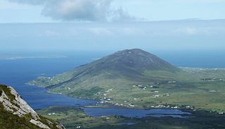
Letter Hill is a large hill near the coast to the north-west of Letterfrack in County Galway, Ireland. It is 356 m (1,168 ft) high and been listed as a Special Area of Conservation.

Holy Trinity Abbey is a former medieval Premonstratensian priory and National Monument located in Lough Key, Ireland.

Loughtee Upper, or Upper Loughtee, is a barony in County Cavan, Ireland. Baronies were mainly cadastral rather than administrative units. They acquired modest local taxation and spending functions in the 19th century before being superseded by the Local Government (Ireland) Act 1898.

Bellamont House is a Georgian Palladian-style house set amongst 1,000 acres of grounds in Cootehill, County Cavan, Ireland. The house was completed in 1730 for Judge Thomas Coote and likely designed by his nephew, the architect Edward Lovett Pearce.


