County Leitrim is a county in Ireland. It is in the province of Connacht and is part of the Northern and Western Region. It is named after the village of Leitrim. Leitrim County Council is the local authority for the county, which had a population of 35,087 according to the 2022 census.

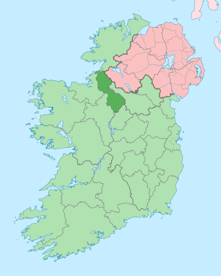
County Cavan is a county in Ireland. It is in the province of Ulster and is part of the Northern and Western Region. It is named after the town of Cavan and is based on the historic Gaelic territory of East Breffny (Bréifne). Cavan County Council is the local authority for the county, which had a population of 81,201 at the 2022 census.

Lough Erne is the name of two connected lakes in County Fermanagh, Northern Ireland. It is the second-biggest lake system in Northern Ireland and Ulster, and the fourth biggest in Ireland. The lakes are widened sections of the River Erne, which flows north and then curves west into the Atlantic. The smaller southern lake is called the Upper Lough as it is higher up the river. The bigger northern lake is called the Lower Lough or Broad Lough. The town of Enniskillen lies on the short stretch of river between the lakes. The lake has more than 150 islands, along with many coves and inlets. The River Erne is 80 miles (129 km) long and drains an area of about 1,680 square miles (4,350 km2).
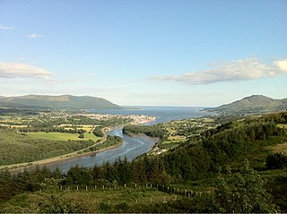
Carlingford Lough is a glacial fjord or sea inlet in northeastern Ireland, forming part of the border between Northern Ireland to the north and the Republic of Ireland to the south. On its northern shore is County Down, the Mourne Mountains, and the town of Warrenpoint; on its southern shore is County Louth, the Cooley Mountains and the village of Carlingford. The Newry River flows into the loch from the northwest.
The River Erne in the northwest of the island of Ireland, is the second-longest river in Ulster, flowing through Northern Ireland and the Republic of Ireland, and forming part of their border.

Cuilcagh is a mountain on the border between County Fermanagh and County Cavan. With a height of 666 metres (2,185 ft) it is the highest point in both counties. It is also the 170th highest peak on the island of Ireland, and Ireland's only cross-border county top. Water from the southern slope flows underground until it emerges some miles away in the Shannon Pot, the traditional source of the River Shannon. The area is sometimes referred to as the Cuilcagh Mountains.

Lough Ramor is a large natural lake of 741 hectares situated near Virginia, County Cavan. From early records Vita Tripartita identified as being in the territory of Cenal Muinreamhair. The literal meaning of the term Muinreamhair is 'fat-neck' and appears to be derived from a prehistoric or mythical ancestor warrior, connoting great strength. Loch Muinreamhair also appears in early manuscripts of the Four Masters.

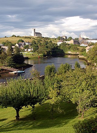
Belturbet is a town in County Cavan, Ireland. It lies on the N3 road, around 14 km (8.7 mi) north of Cavan town and 123 km (76 mi) from Dublin. It is also located around 4 km (2.5 mi) south of the border with Northern Ireland, between the counties of Cavan and Fermanagh, and 36 km (22 mi) from Enniskillen.
The Ulster Canal is a canal running through part of County Armagh, County Tyrone and County Fermanagh in Northern Ireland and County Monaghan in the Republic of Ireland. The Ulster Canal was built between 1825 and 1842 and was 74 km (46 mi) long with 26 locks. It ran from Charlemont on the River Blackwater to near Wattlebridge on the Finn River, south-east of Upper Lough Erne. It was an ill-considered venture, with the locks built narrower than the other Irish waterways, preventing through trade, and an inadequate water supply. It was an abject failure commercially, and contributed to the collapse of the Lagan Navigation Company, who took it over from the government but were then refused permission to abandon it when they could not afford the maintenance costs. It finally closed in 1931. Waterways Ireland started work on rebuilding the canal at its southern end in 2015.

Killeshandra or Killashandra, is a village in County Cavan, Ireland. It is 20 kilometres (12 mi) west of Cavan Town in the centre of County Cavan's lakeland and geopark region and the Erne catchment environment of rivers, lakes, wetlands and woodland. Together with the Lough Oughter Special Protected Area (SPA), it has been recognised by the EU programme for wildlife Natura 2000 since 2010. Killeshandra is noted by Fáilte Ireland as an "Angling Centre of Excellence", and as a hub for the Cavan Walking Festival which takes place in May each year. There are several looped walking and cycling trails in Killykeen Forest Park. The town is also home to Killeshandra Gaelic Football Club, known locally as the Killeshandra Leaguers. Rockfield Lake, which is popular with anglers, is a few kilometres southwest of the town.

Castle Saunderson is a castle near Belturbet in County Cavan, Ireland. It was the former family seat of the Saunderson family, and is now in ruins. The Finn River flows along the north-eastern edge of the Castle Saunderson Demesne, where the river enters a narrow channel of Upper Lough Erne. The castle is about a half a mile west from Wattlebridge, a small hamlet in the south-south-east of County Fermanagh.

Bailieborough Castle was located in Bailieborough, County Cavan, Ireland. It was built in an enclosed demesne by 1629. Also known as Castle House, Lisgar House, or simply 'The Castle', the country house was located just to the south-west of Castle Lough in what is now known as Bailieborough Demesne, on the north-western edge of the town. It was largely destroyed by fire in the early 20th century and is now totally demolished.

The Cuilcagh Lakelands Geopark formerly known as the Marble Arch Caves Global Geopark straddles the border between Northern Ireland and the Republic of Ireland. It is centred on the Marble Arch Caves and in 2001 it became one of the first geoparks to be designated in Europe.

Killykeen Forest Park straddling Lough Oughter is situated in County Cavan, Ireland approximately five miles from Cavan town. Responsibility for the upkeep of Killykeen is through the state's commercial forestry service Coillte together with the National Parks and Wildlife Service (NPWS) where Lough Oughter and its associated loughs are protected under the EU Habitats Directive as a Special Area of Conservation (SAC) and a Special Protection Area (SPA) for wildlife and particularly wintering birds. The forest consists of mainly mixed woodland including Norway and Sitka spruce, Ash, Oak and Beech. The area is popular with anglers because of its location along Lough Oughter which is connected to thousands of hectares of lakeland complexes. Canoeing, biking and windsurfing are also popular activities at the park. Other Attractions include Cloughoughter Castle and Gartnanoul Court Tomb.

Cloughoughter Castle is a ruined circular castle on a small island in Lough Oughter, 4 kilometres (2.5 mi) east of the town of Killeshandra in County Cavan, Ireland.

Gartnanoul is a megalithic court tomb located in Killykeen Forest Park, Loughtee Upper, County Cavan, Ireland. Situated near Lough Oughter, the north tomb court is 3 metres (9.8 ft) in depth and 4 metres (13 ft) in width. Gartnanoul is called a dual-tomb because it has two tombs both in line with each other, with each tomb having its own court. It is estimated that when it was built Gartnanoul was 28 metres (92 ft) long and 8 metres (26 ft) wide. The roof stones are missing although the tomb is in good condition and cairn materials are found scattered around the tomb.
Trawbreaga Bay is a small bay located on the northern tip of the Inishowen Peninsula, County Donegal, Ireland. It is a designated Special Protection Area (SPA) and its features of interest include: the barnacle goose, the light-bellied brent goose, the chough and diverse wetland and waterbirds.

Kiltynaskellan is a townland in the civil parish of Kildallan, barony of Tullyhunco, County Cavan, Ireland.

The Finn River, also known as the River Finn, is a small river that flows through parts of County Fermanagh and parts of County Monaghan in the south of Ulster, the northern province in Ireland. In certain places, the river forms part of the boundary between County Fermanagh, which is part of Northern Ireland, and County Monaghan, which is part of the Republic of Ireland. Two very short stretches of the river, just north of Redhills and at Castle Saunderson, near Belturbet, also form part of the boundary between County Fermanagh and County Cavan. This means that some stretches of the river form part of the border between Northern Ireland and the Republic of Ireland, these short stretches also forming part of the external border of the European Union.
Rockfield Lake, also known as Rockfield Lough, is a lake or lough situated between Carrigallen and Killeshandra, two small towns on the northern edge of the Midlands in Ireland. Part of the lake is in County Leitrim, which is part of the Province of Connacht, while most of the lake is in County Cavan, which is part of the Province of Ulster. This means that the provincial boundary between Connacht and Ulster runs through the lough. The Cullies River flows through Rockfield Lake, entering the lake at its southern end and flowing out of the lake at its north-western end. This small river flows from nearby Cullies Lake, and flows on, via Drumhart Lake, through Rockfield Lake to Glasshouse Lake.


