
Kinvara or Kinvarra is a sea port village in the southwest of County Galway, Ireland. It is located in the civil parish of Kinvarradoorus in the north of the barony of Kiltartan. Kinvarra is also an electoral division.

Kilkelly is a small village in Kilmovee civil parish, County Mayo, Ireland. It is just south of Ireland West Airport on the N17, a national primary road running between Galway and Sligo.

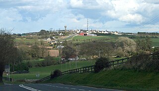
Craughwell is a village and townland in County Galway, Ireland. As of the 2022 census, the village had a population of approximately 1,000 people.

Rosmuc or Ros Muc, sometimes anglicised as Rosmuck, is a village in the Conamara Gaeltacht of County Galway, Ireland. It lies halfway between the town of Clifden and the city of Galway. Irish is the predominant spoken language in the area, with the electoral division of Turlough, Rosmuc, representing one of the highest percentages of Irish-speaking people in the country. The townland of Rosmuck is part of the civil parish of Kilcummin.
Kildorrery is a village in north County Cork, Ireland. It lies at the crossroads of the N73 road from Mallow to Mitchelstown and the R512 from Kilmallock to Fermoy. Kildorrery is part of the Cork East Dáil constituency.

Glenamoy is a village in the civil parish of Kilcommon, Erris in the northern part of County Mayo in Ireland. The R314 road passes through Glenamoy.

Ahascragh is a village in east County Galway, Ireland. It is located 11 km (7 mi) north-west of Ballinasloe on the Ahascragh/Bunowen River, a tributary of the River Suck. The R358 regional road passes through the village. As of the 2022 census, it had a population of 186 people.

Mullinavat is a town in south County Kilkenny, Ireland. Its main industries are tourism and agriculture. The town's name in Irish translates as 'mill of the stick' which, according to local tradition, may refer to a mill which could only be approached by means of a rough stick over the Glendonnel River, close to where Mullinavat Bridge is now located.
Newtowncashel is a village located near Lough Ree in County Longford, Ireland. Newtowncashel won the Irish Tidy Towns Competition in 1980.

Drumone is a small village and townland in western County Meath, Ireland.
Kilcolgan, is a village on the mouth of the Kilcolgan River at Dunkellin Bay in County Galway, Ireland. The settlement is at the junction of the N67 and R458 roads, which lies between Gort and Clarinbridge. The village is near the site of the Galway Bay drowning tragedy. Kilcolgan was designated as a census town by the Central Statistics Office for the first time in the 2016 census, at which time it had a population of 141 people.

Whitegate is a small village in East Cork on the eastern shore of Cork Harbour in County Cork, Ireland. It lies within the townlands of Ballincarroonig and Corkbeg. Whitegate is within the Cork East Dáil constituency.

Ravensdale is a village, townland and electoral division located at the foothills of the Cooley Mountains on the Cooley Peninsula in the north of County Louth in Ireland. Bordering with the townland of Doolargy, Ravensdale is approximately 8 km to the north of Dundalk. The dual carriageway between Dublin and Belfast runs nearby, and the R174 connects it with Jenkinstown.
Sandpit is a small village in the rural hinterland of Drogheda in County Louth, Ireland. It lies in the townland of Milltown, which had a population of 213 as of the 2011 census.

Kilmead, known for census purposes as Kilmeade, is a small village in County Kildare, Ireland. It is 7 kilometres (4 mi) north-east of Athy, on the R418 road.
Kiltivna, also spelled Kiltevna, is a townland in the civil parish of Dunmore in County Galway, Ireland. It is located between the towns of Dunmore and Glenamaddy. The townland, which is 0.78 kilometres (0.48 mi) in area, had a population of 33 people as of the 2011 census.

Aillebrack is a townland on the west coast of Connemara in County Galway, Ireland. As of the 2011 census, the townland had a population of 122 people.

Kiltallagh, sometimes known as Kiltalla, is a civil parish in the historical barony of Trughanacmy in County Kerry, Ireland. Castlemaine is the largest settlement in the civil parish.
Killeenagarriff is a civil parish in the historical barony of Clanwilliam in County Limerick, Ireland. Settlements in Killeenagarriff include the town of Annacotty, and population centres at Ahane and Barringtonsbridge.

Ballysteen is a small village and townland in County Limerick, Ireland. It is located in the civil parish of Iveruss and the historical barony of Kenry.
