King's Lynn Rural District

Last updated
Position within Norfolk, 1894 Kings Lynn RD 1894.png
Position within Norfolk, 1894

Boundaries in 1894.

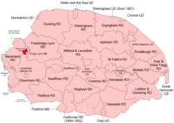
King's Lynn Rural District was a rural district in Norfolk from 1894 to 1935. It was situated on the west bank of the River Great Ouse, opposite the town of King's Lynn, and comprised the then single civil parish of West Lynn.

The district was split in 1935 with the urban part becoming part of the borough of King's Lynn, and the rest becoming part of Marshland Rural District. Today the area covered by the old rural district is within the district of King's Lynn and West Norfolk.

Related Research Articles

<span class="mw-page-title-main">King's Lynn and West Norfolk</span> Borough in England

King's Lynn and West Norfolk is a local government district with borough status in Norfolk, England. Its council is based in the town of King's Lynn. The population of the Local Authority at the 2011 Census was 147,451.

<span class="mw-page-title-main">King's Lynn F.C.</span> Football club

King's Lynn Football Club was an English association football club based in King's Lynn, Norfolk. The club was founded in 1881 and they were wound up at the High Court on 25 November 2009 with debts of £77,000, going out of business in December after a failed appeal. The club was re-formed in January 2010 as Lynn FC and later renamed King's Lynn Town.

<span class="mw-page-title-main">South West Norfolk (UK Parliament constituency)</span> Parliamentary constituency in the United Kingdom, 1885 onwards

South West Norfolk is a constituency represented in the House of Commons of the UK Parliament since 2010 by Liz Truss, a Conservative, who was prime minister of the United Kingdom from September to October 2022.

<span class="mw-page-title-main">Boughton, Norfolk</span> Human settlement in England

Boughton is a village and a civil parish in the English county of Norfolk. The village is 44.4 miles (71.5 km) west of Norwich, 15.1 miles (24.3 km) south-south-east of King’s Lynn and 97.7 miles (157.2 km) north-east of London. The nearest town is Downham Market which is 7.3 miles (11.7 km) west of the village.

<span class="mw-page-title-main">West Lynn, Norfolk</span> Human settlement in England

West Lynn is a village and former civil parish, now in the unparished area of King's Lynn, in the King's Lynn and West Norfolk district, in the county of Norfolk, England. It is west of the River Great Ouse, linked to the main part of King's Lynn by the King's Lynn passenger ferry or by a circuitous 4 km road journey.

Kettering was a rural district in Northamptonshire in England from 1894 to 1974.

<span class="mw-page-title-main">Bingham Rural District</span>

Bingham was a rural district in Nottinghamshire, England from 1894 to 1974.

Leake was a rural district in Nottinghamshire, England from 1894 to 1935.

<span class="mw-page-title-main">Stapleford Rural District</span>

Stapleford was a rural district in Nottinghamshire, England from 1894 to 1935.

<span class="mw-page-title-main">Middleton Cheney Rural District</span>

Middleton Cheney was a rural district in Northamptonshire, England from 1894 to 1935.

Easton on the Hill was a rural district in Northamptonshire, England from 1894 to 1935. It was formed under the Local Government Act 1894 from that part of the Stamford rural sanitary district which was in Northamptonshire proper. It consisted of the three parishes of Collyweston, Duddington and Easton on the Hill.

<span class="mw-page-title-main">Freebridge Lynn Rural District</span>

Freebridge Lynn Rural District was a rural district in Norfolk, England from 1894 to 1974.

Bourne was a rural district in Lincolnshire, Parts of Kesteven from 1894 to 1931.

<span class="mw-page-title-main">East Walton</span> Human settlement in England

East Walton is a village in the English county of Norfolk. The village is located 7.8 miles (12.6 km) south-east of King's Lynn and 31 miles (50 km) north-west of Norwich. East Walton constitutes part of the civil parish of West Acre.

<span class="mw-page-title-main">Gaywood, Norfolk</span> Human settlement in England

Gaywood is an eastern area of the town of King's Lynn, in the unparished area of King's Lynn, in the King's Lynn and West Norfolk district, in the county of Norfolk, England.

<span class="mw-page-title-main">Dersingham railway station</span> Former railway station in North Norfolk, England

Dersingham was a railway station on the King's Lynn to Hunstanton line which served the village of Dersingham, a few miles north of King's Lynn in North Norfolk, England.

<span class="mw-page-title-main">Fring, Norfolk</span> Human settlement in England

Fring is a civil parish in the English county of Norfolk. It covers an area of 6.93 km2 (2.68 sq mi) and had a population of 94 in 41 households at the 2001 census. The population remained less than 100 at the 2011 Census and was included in the civil parish of Sedgeford. For the purposes of local government, it falls within the district of King's Lynn and West Norfolk. There is a small cluster of buildings located along Fring road consisting of Fring All Saints.

<span class="mw-page-title-main">Downham Rural District</span>

Downham Rural District was a rural district in Norfolk, England from 1894 to 1974.

<span class="mw-page-title-main">Marshland Rural District</span>

Marshland Rural District was a rural district in Norfolk, England from 1894 to 1974.

<span class="mw-page-title-main">True's Yard Fisherfolk Museum</span> Social history museum in Kings Lynn, Norfolk

True’s Yard Fisherfolk Museum is a social history museum in King's Lynn, Norfolk. It is an independent museum run almost entirely by volunteers and depicts the story of the old North End fishing quarter of King's Lynn. Support was received from the late Bernard Matthews and others. Most of the North End was knocked down in the slum clearances of the 1930s and 1960s.

References

Coordinates: 52°45′N0°22′E / 52.75°N 0.37°E / 52.75; 0.37