
Duggleby Howe is one of the largest round barrows in Britain, located on the southern side of the Great Wold Valley in the district of Ryedale, and is one of four such monuments in this area, known collectively as the Great barrows of East Yorkshire. Duggleby Howe is believed on the basis of artefacts recovered to be of Late Neolithic date, but no radiocarbon dates are available. Howe as a place name is believed to have originated from the Old Norse word haugr.

A tumulus is a mound of earth and stones raised over a grave or graves. Tumuli are also known as barrows, burial mounds or kurgans, and may be found throughout much of the world. A cairn, which is a mound of stones built for various purposes, may also originally have been a tumulus.

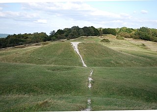
A round barrow is a type of tumulus and is one of the most common types of archaeological monuments. Although concentrated in Europe, they are found in many parts of the world, probably because of their simple construction and universal purpose.
Birmingham, Erdington is a parliamentary constituency. in Birmingham, England.

Wychwood or Wychwood Forest is a 501.7-hectare (1,240-acre) biological Site of Special Scientific Interest north of Witney in Oxfordshire. It is also a Nature Conservation Review site, Grade 1, and an area of 263.4 hectares is a National Nature Reverse The site contains a long barrow dating to the Neolithic period, which is a Scheduled Monument

Poynings is a village and civil parish in the Mid Sussex District of West Sussex, England. The parish lies wholly with the South Downs National Park. The planning authority for Pyecombe is therefore the South Downs National Park Authority (SDNPA), the statutory planning authority for the National Park area.

Round Loaf is a late-Neolithic or Bronze Age tumulus on Anglezarke Moor in the West Pennine Moors near Chorley in Lancashire, England. The bowl barrow is a scheduled monument considered to be of national importance. It was first scheduled in March 1954. The structure is aligned between Great Hill and Pikestones.

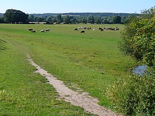
White Sheet Hill, also known as Whitesheet Hill, is a hill in the English county of Wiltshire. As one of the most westerly areas of downland in Britain the area is noted for its chalky farmland which contains a rich variety of rare and protected fauna and flora. The hill is also the site of a neolithic causeway camp and barrows; and an Iron Age hill fort. The Roman road which runs along the hill was at one time the main route through the Selwood Forest. The hill is part of the Stourhead estate and has been in the ownership of the National Trust since 1946.

The Bull Ring is a Class II henge that was built in the late Neolithic period near Dove Holes in Derbyshire, England.

Kingstanding is an area in north Birmingham, England. It gives its name to a ward in the Erdington council constituency. Kingstanding ward includes the areas; Perry Common, Witton Lakes and Wyrley Birch. The other part of Kingstanding falls under the Oscott ward.
Cock Marsh is an 18.3-hectare (45-acre) biological Site of Special Scientific Interest north of Maidenhead in Berkshire. It is also the location of a Round barrow cemetery and common land where livestock have grazed for hundreds of years. Cock Marsh is managed by the National Trust.

Brown Low is a bowl barrow most likely dating to the Bronze Age. An earth and stone mound survives east of Marple, Greater Manchester. It is listed as a Scheduled Ancient Monument. The mound was partially excavated by the Rev William Marriott in 1809, who discovered fragments of burnt stones and cremated bones, as well as a preserved acorn. Marriott also describes the finding of a funerary urn in an adjacent barrow during an unauthorised excavation. Brown Low is located in private land, just east of a public footpath running off Sandy Lane.
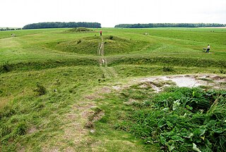
The Cursus Barrows is the name given to a Neolithic and Bronze Age round barrow cemetery located mostly south of the western end of the Stonehenge Cursus. The cemetery contains around 18 round barrows scattered along an east-to-west ridge, although some of the mounds are no longer visible. The Cursus Barrows can be seen just north of the route between the Stonehenge Visitor Centre and Stonehenge.
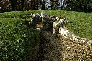
Nympsfield Long Barrow is the remains of a Neolithic burial site or barrow, located close to the village of Nympsfield in Gloucestershire, South West England.

Llanfechell is a village in Anglesey, North Wales, UK. It is the largest of several small villages and dispersed settlements that make up Mechell Community Council area. It is 11 miles (18 km) east of Holyhead, and 5.6 miles (9.0 km) west of Amlwch, on the north of the island.
The Devil's Humps are four Bronze Age barrows situated on Bow Hill on the South Downs near Stoughton, West Sussex. They are situated on a downland ridgeway crossed by an ancient trackway, above Kingley Vale. The Devil's Humps are counted among the most impressive round barrows surviving on the South Downs. The Devil's Humps are within the Kingley Vale National Nature Reserve. The two bell barrows together with two pond barrows and a cross dyke are listed as Scheduled Ancient Monument 1008371, while the two bowl barrows are listed as Scheduled Ancient Monument 1008372.

Bishopstrow House, currently occupied by the Bishopstrow House Hotel, is a late-Georgian English country house standing near the B3414 in the parish of Bishopstrow, about a mile east of Warminster, Wiltshire.

Beacon Hill, also known as Harting Beacon, is a hillfort on the South Downs, in the county of West Sussex in southern England. The hillfort is located in the parish of Elsted and Treyford, in Chichester District. It is a Scheduled Ancient Monument with a list entry identification number of 1015915. The hilltop enclosure is dated to the Late Bronze Age, from the 8th to 6th centuries BC. The hillfort defences were renewed during the Late Iron Age.

Benty Grange is a Site of Special Scientific Interest in the parish of Monyash in Derbyshire, England. 21.1 ha in size and with at least four species of grass and ten others of plant, it is considered of national importance as one of the largest areas of unimproved species-rich neutral lowland grassland in the Peak District National Park. The area was confirmed as a Site of Special Scientific Interest on 8 March 2013, following notification of the designation on 19 June 2012.

Asthall barrow is a high-status Anglo-Saxon burial mound from the seventh century AD. It is located in Asthall, Oxfordshire, and was excavated in 1923 and 1924.
