The Geography of Guyana comprises the physical characteristics of the country in Northern South America and part of Caribbean South America, bordering the North Atlantic Ocean, between Suriname and Venezuela, with a land area of approximately 214,969 square km. The country is situated between 1 and 9 north latitude and between 56 and 62 west longitude. With a 459 km (285 mi)-long Atlantic coastline on the northeast, Guyana is bounded by Venezuela on the west, Brazil on the west and south, and Suriname on the east.
A waterfall is a point in a river or stream where water flows over a vertical drop or a series of steep drops. Waterfalls also occur where meltwater drops over the edge of a tabular iceberg or ice shelf.
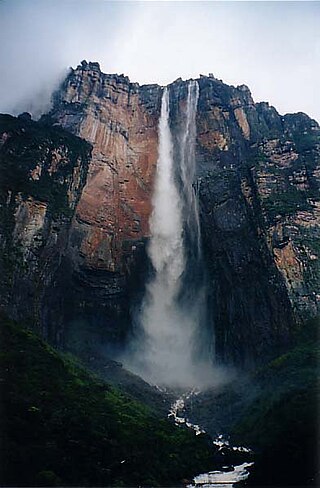
Angel Falls is a waterfall in Venezuela. It is the world's tallest uninterrupted waterfall, with a height of 979 metres (3,212 ft) and a plunge of 807 m (2,648 ft). The waterfall drops over the edge of the Auyán-tepui mountain in the Canaima National Park, a UNESCO World Heritage site in the Gran Sabana region of Bolívar State. The height figure, 979 m (3,212 ft), mostly consists of the main plunge but also includes about 400 metres (1,300 ft) of sloped cascade and rapids below the drop and a 30-metre-high (100 ft) plunge downstream of the talus rapids.

Kukenan Falls is the second tallest major waterfall in Venezuela after Angel Falls. It is also the second tallest free-leaping waterfall in the world. Overall, it is usually cited as the 11th highest waterfall in the world. The falls drop in a single leap of around 2,211 feet (674 m) and the final portion of the falls trickles down towards the base of the Kukenan Tepui.

The Pemon or Pemón (Pemong) are indigenous people living in areas of Venezuela, Brazil, and Guyana. They are also known as Arecuna, Aricuna Jaricuna, Kamarakoto, and Taurepang.

Canaima National Park is a 30,000 km2 (12,000 sq mi) park in south-eastern Venezuela that roughly occupies the same area as the Gran Sabana region. It is located in Bolívar State, reaching the borders with Brazil and Guyana. The park was named a World Heritage Site by UNESCO.
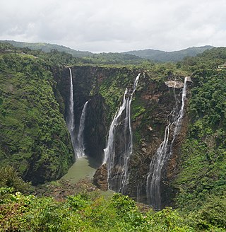
Jog Falls is a waterfall on the Sharavati river located in the Western Ghats running between Uttara Kannada and Shimoga districts of Karnataka, India. It is the third highest plunge waterfall in India. It is a segmented waterfall which depends on rain and season to become a plunge waterfall. The falls are major attractions for tourists and is ranked 36th in the list of free-falling waterfalls, 490th in the world by list of waterfalls by total height, 128th in the list of single-drop waterfalls in the World by the waterfall database.

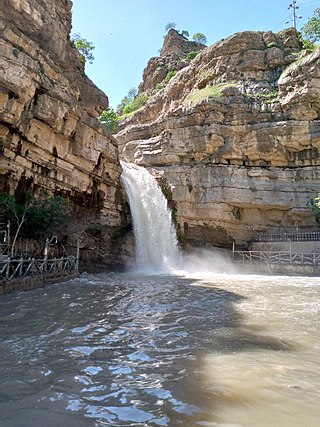
Kaieteur is the Guyana´s largest single drop waterfall. Located on the Potaro River in the Kaieteur National Park, it sits in a section of the Amazon rainforest included in the Potaro-Siparuni region of Guyana. It is 226 metres (741 ft) high when measured from its plunge over a sandstone and conglomerate cliff to the first break. It then flows over a series of steep cascades that, when included in the measurements, bring the total height to 251 metres (822 ft). While many falls have greater height, few have the combination of height and water volume, and Kaieteur is among the most powerful waterfalls in the world with an average flow rate of 663 cubic metres per second.

The Tequendama Falls is a 132 metres (433 ft) high waterfall of the Bogotá River, located 32 kilometres (20 mi) southwest of Bogotá in the municipality of Soacha. Established in approximately 10,000 BCE, El Abra and Tequendama were the first permanent settlements in Colombia. One of the country's tourist attractions, the falls are located in a forested area 32 kilometres (20 mi) west of Bogotá. The river surges through a rocky gorge that narrows to about 18 metres (59 ft) at the brink of the 132 metres (433 ft) high falls. During the month of December the falls become completely dry. The falls, once a common site for suicides, may be reached by road from Bogotá.
King Edward VIII Falls is an 260-metre-tall (850 ft) single plunge waterfall found on the Semang River in the Potaro-Siparuni highlands, southern Guyana, named for Edward VIII.
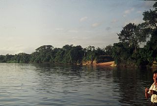
The Caura, is a tributary of the Orinoco River, located in Bolívar State in Venezuela. Its flow is the second after the Caroni River among the affluents of the Orinoco River, with almost 3,544 cubic metres per second (125,200 cu ft/s). The river is inhabited by both the Ye'kuana and Sanema indigenous groups.

Guairá Falls were a series of immense waterfalls on the Paraná River along the border between Paraguay and Brazil. The falls ceased to exist in 1982 when they were inundated by the impoundment of the Itaipu Dam reservoir. While published figures vary, ranging from 13,000 m3 (470,000 cu ft) per second to 50,000 m3 (1,750,000 cu ft) per second, Guaíra's flow rate was among the greatest of any then-existing falls on Earth.

Guyana, officially the Co‑operative Republic of Guyana, is a country on the northern mainland of South America. Guyana is an indigenous word which means "Land of Many Waters". The capital city is Georgetown. Guyana is bordered by the Atlantic Ocean to the north, Brazil to the south and southwest, Venezuela to the west, and Suriname to the east. With 215,000 km2 (83,000 sq mi), Guyana is the third-smallest sovereign state by area in mainland South America after Uruguay and Suriname, and is the second-least populous sovereign state in South America after Suriname; it is also one of the least densely populated countries on Earth. It has a wide variety of natural habitats and a very high biodiversity.

Kamarang River is a river in Venezuela and Guyana, and a part of the Essequibo River basin.
Paruima is an indigenous village of Pemon Amerindians in the Cuyuni-Mazaruni Region of Guyana. The village was founded as a mission of the Seventh-day Adventist Church. It is the only Pemon speaking community in Guyana.
Nappi is an indigenous village of Macushi Amerindians in the Upper Takutu-Upper Essequibo Region of Guyana. It is located in the Rupununi savannah along the Nappi and Maipaima creeks on the edge of the Kanuku Mountains.


