
Bridgwater is a historic market town and civil parish in Somerset, England. The town had a population of 41,276 at the 2021 census. Bridgwater is at the edge of the Somerset Levels, in level and well-wooded country. The town lies along both sides of the River Parrett; it has been a major inland port and trading centre since the industrial revolution. Most of its industrial bases still stand today. Its larger neighbour, Taunton, is linked to Bridgwater via a canal, the M5 motorway and the GWR railway line.

North Petherton is a town and civil parish in Somerset, England, situated on the edge of the eastern foothills of the Quantocks, and close to the edge of the Somerset Levels. The town has a population of 6,730 as of 2014. The parish includes Hamp, Melcombe, Shearston, Woolmersdon and Huntworth.

Bawdrip is a village and civil parish in Somerset, England. The village is on the south side of the Polden Hills about 4 miles (6.4 km) north-east of Bridgwater. At the 2011 census the parish had a population of 506. The parish includes the hamlets of Bradney, Horsey and Knowle.

Bridgwater Castle was a castle in the town of Bridgwater, Somerset, England.
Spaxton is a small village and civil parish on the Quantocks in Somerset, South West England.

Durleigh is a village and civil parish on the outskirts of Bridgwater in Somerset, England. According to the 2011 Census, it had a population of 548. Its nearest town is Bridgwater, which lies approximately 1.6 miles (2.6 km) north-east from the village.
Sedgemoor is a local government district in the English county of Somerset. In the United Kingdom, the term listed building refers to a building or other structure officially designated as being of special architectural, historical or cultural significance; Grade I structures are those considered to be "buildings of exceptional interest". Listing was begun by a provision in the Town and Country Planning Act 1947. Once listed, severe restrictions are imposed on the modifications allowed to a building's structure or its fittings. In England, the authority for listing under the Planning Act 1990 rests with Historic England, a non-departmental public body sponsored by the Department for Digital, Culture, Media and Sport; local authorities have a responsibility to regulate and enforce the planning regulations.

The Lions House on West Quay in Bridgwater, Somerset, England was built around 1725 and has been designated as a Grade I listed building.

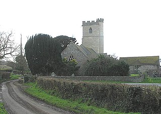
The Church of St Mary at Charlynch in the parish of Spaxton, Somerset, England was an Anglican Parish Church, but has now been deconsecrated. It dates from the 11th century with a tower probably of 1867. It has been designated as a Grade I listed building.

The Corn Exchange is a commercial building in Cornhill, Bridgwater, Somerset, England. The structure, which is now used as a chain restaurant, is a Grade I listed building.
All Saints Church in Otterhampton, Somerset, England, overlooks the River Parrett. The church dates from the 14th century. It is recorded in the National Heritage List for England as a designated Grade II* listed building, and is a redundant church in the care of the Churches Conservation Trust. It was declared redundant on 1 March 1988, and was vested in the Trust on 2 August 1989.

Enmore Castle is a historic building in the village of Enmore, Somerset, England. It is a Grade II listed building.

The Hundred of North Petherton is one of the 40 historical Hundreds in the ceremonial county of Somerset, England, dating from before the Norman conquest. Although the Hundreds have never been formally abolished, their functions ended with the establishment of county courts in 1867 and the introduction of districts by the Local Government Act 1894. The name of the hundred derives from the name of the large royal estate that covered much of the area in 1086, recorded variously as Nortpetret in the Domesday Book, Nortpedret in Liber Exoniensis and Nort Peretu in the associated tax returns. This, in turn, was derived from the area's location to the northern end of the River Parrett.
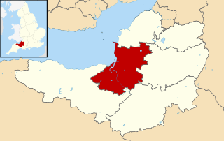
Sedgemoor is a local government district in the English county of Somerset. In the United Kingdom, the term listed building refers to a building or other structure officially designated as being of special architectural, historical or cultural significance; Grade II* structures are those considered to be "particularly significant buildings of more than local interest". Listing was begun by a provision in the Town and Country Planning Act 1947. Once listed, severe restrictions are imposed on the modifications allowed to a building's structure or its fittings. In England, the authority for listing under the Planning Act 1990 rests with Historic England, a non-departmental public body sponsored by the Department for Digital, Culture, Media and Sport; local authorities have a responsibility to regulate and enforce the planning regulations.

Petherton Park was a Deer park around North Petherton within the English county of Somerset.

The Anglican St Mary's Church at Stringston in the English county of Somerset dates from the 17th century. It has been designated as a Grade II listed building.
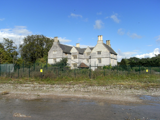
Sydenham House, the manor house of the ancient manor of Sydenham in the parish of Wembdon, Somerset, England, is a grade II listed building, constructed in the early 16th century and refronted and rebuilt after 1613. In 1937, British Cellophane Ltd set up production and built extensive factories on 59 acres (24 ha) of land adjacent to the manor house. Production ceased in 2005 and between 2010 and 2015 the industrial site was razed to the ground. In 2015 the razed site is owned by EDF Energy, which in 2012 purchased the manor house with the former factory site, intended for construction of temporary accommodation for 1,000 workers.

West Bower Manor in Durleigh within the English county of Somerset was largely built in the 15th century. It is a Grade II* listed building.
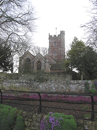
The Church of St Hugh at Durleigh in the English county of Somerset was built in the 11th century. It is a Grade II* listed building.

The Anglican Church of St Peter in North Newton within the English county of Somerset has a tower believed to date from Saxon times. It is a Grade II* listed building.

